Baie-Saint-Paul

Last updated

Baie-Saint-Paul
Baie-Saint-Paul.jpg
Blason ville ca Baie-Saint-Paul (Quebec).svg
Baie-Saint-Paul Quebec location diagram.png
Location within Charlevoix RCM.
Canada Central Quebec location map.png
Red pog.svg
Baie-Saint-Paul
Location in central Quebec.
Coordinates: 47°27′N70°30′W / 47.450°N 70.500°W / 47.450; -70.500 [1]
CountryFlag of Canada (Pantone).svg  Canada
Province Flag of Quebec.svg  Quebec
Region Capitale-Nationale
RCM Charlevoix
ConstitutedJanuary 3, 1996
Government
[2]
  MayorMichaël Pilote
   Federal riding Beauport—Côte-de-Beaupré—Île d'Orléans—Charlevoix
   Prov. riding Charlevoix–Côte-de-Beaupré
Area
   City 563.70 km2 (217.65 sq mi)
  Land546.48 km2 (211.00 sq mi)
  Urban
5.99 km2 (2.31 sq mi)
Population
 (2016) [4]
   City 7,146
  Density13.1/km2 (34/sq mi)
   Urban
4,535
  Urban density760.0/km2 (1,968/sq mi)
  Pop 2011–2016
Decrease2.svg 2.5%
  Dwellings
3,231
Time zone UTC−5 (EST)
  Summer (DST) UTC−4 (EDT)
Postal code(s)
G3Z
Area codes 418 and 581
HighwaysQc138.svg R-138
Qc362.svg R-362
Qc381.svg R-381
Website www.baiesaintpaul.com

Baie-Saint-Paul (2011 Population 7,332; UA population 4,535) is a city in the Province of Quebec, Canada, on the northern shore of the Saint Lawrence River. Baie-Saint-Paul is the seat of Charlevoix Regional County Municipality. The city is situated at the mouth of the Gouffre River. It is known for its art galleries, shops and restaurants.

Contents

The place gained some prominence in the 1770s when Doctor Philippe-Louis-François Badelard named a disease he was researching the "Baie-Saint-Paul maladie". This illness was the subject of one of the first medical publications done in Lower Canada. It is also where Cirque du Soleil originated back in the early 1980s and the location of the first show using the name Cirque du Soleil during "La Fete Foraine de Baie-Saint-Paul" in 1984.

A visitor in the early 1800s noticed mineral springs and mineral resources in the area. [5]

Demographics

In the 2021 Census of Population conducted by Statistics Canada, Baie-Saint-Paul had a population of 7,371 living in 3,427 of its 3,782 total private dwellings, a change of

Population trend: [7]

Mother tongue:

Street views of Baie-Saint-Paul

Climate

Baie-Saint Paul has a humid continental climate with vast seasonal differences. Summers are mild and moderated by its proximity to the Gulf of Saint Lawrence. In winter, interior Canada influences the climate with frequent cold waves.

Climate data for Baie-Saint-Paul
MonthJanFebMarAprMayJunJulAugSepOctNovDecYear
Record high °C (°F)11.0
(51.8)
12.0
(53.6)
16.0
(60.8)
30.0
(86.0)
35.5
(95.9)
33.9
(93.0)
35.6
(96.1)
34.0
(93.2)
33.0
(91.4)
25.0
(77.0)
18.5
(65.3)
13.5
(56.3)
35.6
(96.1)
Mean daily maximum °C (°F)−6.9
(19.6)
−4.5
(23.9)
0.7
(33.3)
7.4
(45.3)
15.6
(60.1)
21.2
(70.2)
23.9
(75.0)
22.5
(72.5)
17.3
(63.1)
10.8
(51.4)
3.5
(38.3)
−3.8
(25.2)
9.0
(48.2)
Daily mean °C (°F)−12.5
(9.5)
−10.2
(13.6)
−4.4
(24.1)
2.9
(37.2)
10.1
(50.2)
15.6
(60.1)
18.5
(65.3)
17.1
(62.8)
12.2
(54.0)
6.3
(43.3)
−0.5
(31.1)
−8.7
(16.3)
3.9
(39.0)
Mean daily minimum °C (°F)−18.2
(−0.8)
−16
(3)
−9.5
(14.9)
−1.6
(29.1)
4.5
(40.1)
10.0
(50.0)
12.9
(55.2)
11.7
(53.1)
7.1
(44.8)
1.8
(35.2)
−4.4
(24.1)
−13.5
(7.7)
−1.3
(29.7)
Record low °C (°F)−36
(−33)
−34.4
(−29.9)
−32
(−26)
−18
(0)
−6.7
(19.9)
−0.5
(31.1)
2.8
(37.0)
0.5
(32.9)
−5
(23)
−9
(16)
−23.9
(−11.0)
−33
(−27)
−36
(−33)
Average precipitation mm (inches)74.1
(2.92)
63.0
(2.48)
83.5
(3.29)
94.6
(3.72)
95.5
(3.76)
94.7
(3.73)
86.3
(3.40)
85.9
(3.38)
83.4
(3.28)
80.3
(3.16)
79.1
(3.11)
78.8
(3.10)
999.3
(39.34)
Average rainfall mm (inches)14.0
(0.55)
12.7
(0.50)
39.2
(1.54)
76.1
(3.00)
95.0
(3.74)
94.7
(3.73)
86.3
(3.40)
85.9
(3.38)
83.4
(3.28)
78.5
(3.09)
53.0
(2.09)
9.4
(0.37)
728.0
(28.66)
Average snowfall cm (inches)60.2
(23.7)
50.4
(19.8)
44.3
(17.4)
17.1
(6.7)
0.5
(0.2)
0
(0)
0
(0)
0
(0)
0
(0)
1.7
(0.7)
26.1
(10.3)
69.4
(27.3)
269.8
(106.2)
Average precipitation days (≥ 0.2 mm)9.77.19.410.311.712.513.113.311.110.99.610.5129.3
Average rainy days (≥ 0.2 mm)1.51.04.18.911.712.513.113.311.110.76.31.996.2
Average snowy days (≥ 0.2 cm)8.96.36.32.60.0700000.413.99.437.8
Source: Environment Canada [8]

See also

Related Research Articles

<span class="mw-page-title-main">Saint-Félicien, Quebec</span> City in Quebec, Canada

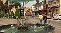
Saint-Félicien is a city in the Canadian province of Quebec. The town is located within the Le Domaine-du-Roy Regional County Municipality in the Saguenay-Lac-Saint-Jean region. Its population as of 2023 is 10,226.

<span class="mw-page-title-main">Saint-Urbain, Quebec</span> Parish municipality in Quebec, Canada

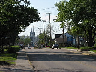
Saint-Urbain is a parish municipality located in the Charlevoix Regional County Municipality, in Capitale-Nationale region, in Quebec, Canada.

<span class="mw-page-title-main">Saint-Hilarion, Quebec</span> Parish municipality in Quebec, Canada

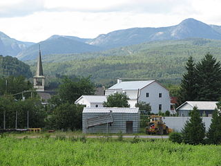
Saint-Hilarion is a parish municipality in Charlevoix Regional County Municipality, in the administrative region of Capitale-Nationale of the province of Quebec, in Canada.

<span class="mw-page-title-main">Petite-Rivière-Saint-François</span> Municipality in Quebec, Canada

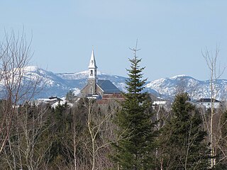
Petite-Rivière-Saint-François is a municipality in Quebec, Canada, along the Saint Lawrence River. It is considered the gateway to the Charlevoix region.

<span class="mw-page-title-main">Sault-au-Cochon, Quebec</span> Unorganized territory in Quebec, Canada

Sault-au-Cochon is an unorganized territory in the Capitale-Nationale region of Quebec, Canada, in the La Côte-de-Beaupré Regional County Municipality. It is an unpopulated and undeveloped stretch of shoreline along the Saint Lawrence River that encompasses the promontory from Cape Tourmente to Petite-Rivière-Saint-François.

<span class="mw-page-title-main">Lac-Pikauba, Quebec</span> Unorganized territory in Quebec, Canada

Lac-Pikauba is an unorganized territory in the Capitale-Nationale region of Quebec, Canada. It is a large, unpopulated, undeveloped territory that makes up two-thirds of the Charlevoix Regional County Municipality.

<span class="mw-page-title-main">Rivière du Gouffre</span> River in Charlevoix (Québec, Canada)

The rivière du Gouffre is a tributary of the left bank of the Saint-Laurent river, flowing into the Capitale-Nationale administrative region, Quebec (Canada). This watercourse flows through Regional County Municipality from:

The Rivière des Îlets is a tributary of the southern bank of the upper part of the Rivière du Gouffre, flowing in the unorganized territory of Lac-Pikauba, in the Charlevoix Regional County Municipality, in the administrative region of Capitale-Nationale, in the province of Quebec, in Canada.

The Chicago River is a tributary of the east bank of the middle part of the Rivière du Gouffre, flowing in the administrative region of Capitale-Nationale, in the province from Quebec, to Canada. The course of this river flows through the regional county municipalities (MRCs) of:

The Renaud River is a tributary of the west bank of the lower part of the rivière du Gouffre, flowing entirely in the town of Baie-Saint-Paul, in the Charlevoix Regional County Municipality, in the administrative region of Capitale-Nationale, in the province from Quebec, to Canada.

The Rémy River is a tributary of the west bank of the lower part of the rivière du Gouffre, flowing in the municipality of Saint-Urbain, in the Charlevoix Regional County Municipality, in the administrative region of Capitale-Nationale, in the province of Quebec, in Canada.

The rivière des Mares is a tributary of the west bank of the lower part of the Rivière du Gouffre, flowing entirely in the town of Baie-Saint-Paul, in the Charlevoix Regional County Municipality, in the administrative region of Capitale-Nationale, in the province from Quebec, to Canada.

La Grosse Décharge Ouest is a tributary of the west bank of the upper part of the rivière des Mares, flowing entirely in the town of Baie-Saint-Paul, in the Charlevoix Regional County Municipality, in the administrative region of Capitale-Nationale, in the province from Quebec, to Canada.

La Grosse Décharge Est is a tributary of the north shore of La Grosse Décharge Ouest, flowing entirely in the town of Baie-Saint-Paul, in the Charlevoix Regional County Municipality, in the administrative region of Capitale-Nationale, in the province of Quebec, in Canada.

The ruisseau du Pied du Mont is a tributary of the southern bank of the upper part of the rivière des Mares, flowing entirely in the town of Baie-Saint-Paul, in the Charlevoix Regional County Municipality, in the administrative region of Capitale-Nationale, in the province of Quebec, in Canada.

The rivière à Ange is a tributary of the West shore of the ruisseau du Pied du Mont, flowing entirely in the town of Baie-Saint-Paul, in the Charlevoix Regional County Municipality, in the administrative region of Capitale-Nationale, in the province of Quebec, in Canada.

The rivière à Idas is a tributary of the north bank of the upper part of the Bras du Nord-Ouest, flowing entirely in the town of Baie-Saint-Paul, in the Charlevoix Regional County Municipality, in the administrative region of Capitale-Nationale, in the province of Quebec, in Canada.

<span class="mw-page-title-main">Bras du Nord-Ouest</span> River in Quebec, Canada

The Bras du Nord-Ouest is a tributary of the west bank of the lower part of the rivière du Gouffre, flowing entirely in the city of Baie-Saint-Paul, in the Charlevoix Regional County Municipality, in the administrative region of Capitale-Nationale, in the province of Quebec, in Canada.

The ruisseau de la Goudronnerie is a tributary of the eastern bank of the lower part of the rivière du Gouffre, flowing in the territory of the town of Baie-Saint-Paul, in the Charlevoix Regional County Municipality, in the administrative region of Capitale-Nationale, in the province from Quebec, to Canada.

The "Lac La Flippe" is a body of fresh water located in the territory of the town of Baie-Saint-Paul, in the Charlevoix Regional County Municipality, in the administrative region of Capitale-Nationale, in the province of Quebec, in Canada.

References

  1. "Banque de noms de lieux du Québec: Reference number 313455". toponymie.gouv.qc.ca (in French). Commission de toponymie du Québec.
  2. 1 2 Ministère des Affaires municipales, des Régions et de l'Occupation du territoire - Répertoire des municipalités: Baie-Saint-Paul Archived 2011-01-08 at the Wayback Machine
  3. Statistics Canada 2011 Census - Baie-Saint-Paul census profile
  4. Statistics Canada 2016 Census - Petite-Rivière-Saint-François census profile
  5. Baddeley, Frederick Henry (1831). "Additional notes on the Geognosy of St. Paul's Bay". Transactions. Original Series. Literary and Historical Society of Quebec. 2. Archived from the original on May 3, 2013. Retrieved April 27, 2013.
  6. "Population and dwelling counts: Canada, provinces and territories, and census subdivisions (municipalities), Quebec". Statistics Canada. February 9, 2022. Retrieved August 29, 2022.
  7. Statistics Canada: 1996, 2001, 2006, 2011, 2016, 2021
  8. Environment CanadaCanadian Climate Normals 1971-2000. Retrieved April 6, 2012.