Saint-Hilarion, Quebec

Last updated
Saint-Hilarion
St-Hilarion.jpg
Church of Saint-Hilarion overlooking the village
Saint-Hilarion Quebec location diagram.png
Location within Charlevoix RCM.
Canada Central Quebec location map.png
Red pog.svg
Saint-Hilarion
Location in central Quebec.
Coordinates: 47°34′N70°24′W / 47.567°N 70.400°W / 47.567; -70.400 Coordinates: 47°34′N70°24′W / 47.567°N 70.400°W / 47.567; -70.400 [1]
CountryFlag of Canada (Pantone).svg  Canada
Province Flag of Quebec.svg  Quebec
Region Capitale-Nationale
RCM Charlevoix
ConstitutedJuly 1, 1855
Government
[2]
  MayorRosaire Lavoie
   Federal riding Montmorency—Charlevoix
—Haute-Côte-Nord
   Prov. riding Charlevoix–Côte-de-Beaupré
Area
  Total101.00 km2 (39.00 sq mi)
  Land99.65 km2 (38.48 sq mi)
Population
 (2011) [3]
  Total1,181
  Density11.9/km2 (31/sq mi)
  Pop 2006-2011
Decrease2.svg 0.8%
  Dwellings
572
Time zone UTC−5 (EST)
  Summer (DST) UTC−4 (EDT)
Postal code(s)
Area code(s) 418 and 581
HighwaysQc138.svg Route 138
Website www.sainthilarion.ca

Saint-Hilarion is a parish municipality in Charlevoix Regional County Municipality, in the administrative region of Capitale-Nationale of the province of Quebec, in Canada. [4]

Contents

Geography

A few lakes such as Lac aux Bois-Verts and Lac à la Mine dot the territory. Inserted in the heart of the hinterland, at an altitude of 400 m, Saint-Hilarion sees its landscape marked by the church built on a hill which dominates the surrounding countryside, with several important farms.

History

Colonization of the area began in 1830 with the arrival of the first clearers from the Éboulements. In 1864, the parish of Saint-Hilarion-de-Settrington was erected both civilly and canonically, which gave birth to the municipality of the township of Settrington in 1855, which became the municipality of the parish of Saint-Hilarion in 1956. The post office, opened in 1860, also takes the name of the township proclaimed in 1822, taken from that of a village in English Yorkshire. In 1892, it will receive its current name, identical to that of the municipality.

Toponymy

As the Saint-Hilarionian winters were hasty and harsh, it is believed that the choice of the name of Saint Hilarion, a very austere monk from the beginning of Christianity, was imposed. Born in Tabatha, Palestine, around 291, he was to die around 371. In the north of the island of Cyprus a church Byzantine Architecture of the 10th century which bears the name of Saint-Hilarion. This extraordinary ancient site includes the ruins of a château built around a once important hermitage. [5]

Personalities

The most famous son of Saint-Hilarion remains the journalist Olivar Asselin (1874-1937) who participated in the founding of the newspaper Le Devoir in 1910.

Geology

The municipality of Saint-Hilarion lies about ten kilometers from the center of the Charlevoix impact structure, discovered in 1968 and which, in 2009, is considered the thirteenth largest impact structure identified on Earth. (The municipality of Les Éboulements being the center). Its soil, as in many municipalities in Charlevoix, is full of impactite, rocky material found at the site of a meteoric impact. An asteroid with a diameter of 2 kilometers struck the Charlevoix region about 350 million years ago, creating an impact structure 56 kilometers in diameter. The Charlevoix region is known for its regular seismic activity within the Charlevoix Seismic Zone, even if the tremors are not always felt. There is a tremor every two days, very weak magnitude.

Major earthquakes felt in Saint-Hilarion:

Demographics

In the 2021 Census of Population conducted by Statistics Canada, Saint-Hilarion had a population of 1,146 living in 492 of its 533 total private dwellings, a change of

Population trend: [7]

Mother tongue:

Related Research Articles

<span class="mw-page-title-main">L'Anse-Saint-Jean, Quebec</span> Municipality in Quebec, Canada

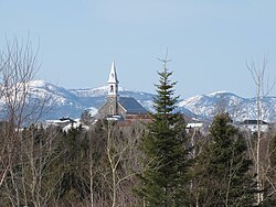
L'Anse-Saint-Jean, French for "The Cove of Saint John" is a municipality in the Saguenay–Lac-Saint-Jean region of Quebec, Canada. Its population was 1208 in the Canada 2011 Census.

<span class="mw-page-title-main">Baie-Saint-Paul</span> City in Quebec, Canada

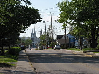
Baie-Saint-Paul is a city in the Province of Quebec, Canada, on the northern shore of the Saint Lawrence River. Baie-Saint-Paul is the seat of Charlevoix Regional County Municipality. The city is situated at the mouth of the Gouffre River. It is known for its art galleries, shops and restaurants.

<span class="mw-page-title-main">L'Isle-aux-Coudres</span> Municipality in Quebec, Canada

L'Isle-aux-Coudres is a municipality in Quebec, Canada, in the Charlevoix Regional County Municipality in the Charlevoix area of the Capitale-Nationale region. It is located on and contiguous with Coudres Island, located in the St. Lawrence River about 6 kilometres (3.7 mi) south from the mainland.

<span class="mw-page-title-main">Saint-Prosper-de-Champlain, Quebec</span> Municipality in Quebec, Canada

Saint-Prosper-de-Champlain is a municipality of 516 people in the Les Chenaux Regional County Municipality, in Quebec, Canada. It is the smallest municipality in terms of population in the regional county.

<span class="mw-page-title-main">Saint-Félicien, Quebec</span> City in Quebec, Canada

Saint-Félicien is a city in the Canadian province of Quebec. The town is located within the Le Domaine-du-Roy Regional County Municipality in the Saguenay-Lac-Saint-Jean region. Its population as of 2006 is 10,477.

<span class="mw-page-title-main">Saint-Antonin, Quebec</span> City in Quebec, Canada

Saint-Antonin is a city in the Bas-Saint-Laurent region of Quebec, Canada, a few kilometres south of the city of Rivière-du-Loup, in Rivière-du-Loup Regional County Municipality. The municipality is named after Louis-Antonin or Antoine Proulx (1810-1896), priest of Fraserville (Rivière-du-Loup) and was founded in 1856.

<span class="mw-page-title-main">Saint-Urbain, Quebec</span> Parish municipality in Quebec, Canada

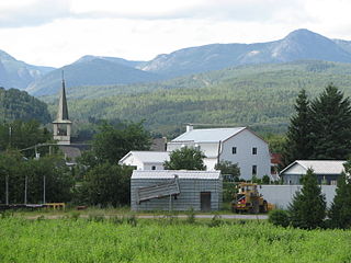
Saint-Urbain is a parish municipality located in the Charlevoix Regional County Municipality, in Capitale-Nationale region, in Quebec, Canada.

<span class="mw-page-title-main">Saint-Colomban, Quebec</span> City in Quebec, Canada

Saint-Colomban is a city in the regional county municipality of La Rivière-du-Nord in Québec, Canada. It is situated in the Laurentides region of Québec and was named in honour of Saint Columbanus.

<span class="mw-page-title-main">Saint-André-d'Argenteuil</span> Municipality in Quebec, Canada

Saint-André-d'Argenteuil is a municipality in the Laurentides region of Quebec, Canada, part of the Argenteuil Regional County Municipality. It is located along the Ottawa River, just south of Lachute.

<span class="mw-page-title-main">Saint-Irénée, Quebec</span> Municipality in Quebec, Canada

Saint-Irénée is a municipality in the Capitale-Nationale region of Quebec, Canada.

<span class="mw-page-title-main">Notre-Dame-des-Monts</span> Municipality in Quebec, Canada

Notre-Dame-des-Monts is a municipality of Charlevoix-Est Regional County Municipality, in the Capitale-Nationale region of Quebec, Canada.

<span class="mw-page-title-main">Petite-Rivière-Saint-François</span> Municipality in Quebec, Canada

Petite-Rivière-Saint-François is a municipality in Quebec, Canada, along the Saint Lawrence River. It is considered the gateway to the Charlevoix region.

<span class="mw-page-title-main">Les Éboulements</span> Municipality in Quebec, Canada

Les Éboulements is a municipality in the Capitale-Nationale region of Quebec, Canada.

<span class="mw-page-title-main">Sainte-Hedwidge, Quebec</span> Municipality in Quebec, Canada

Sainte-Hedwidge is a municipality in Quebec, Canada. The community is also known as Sainte-Hedwidge-de-Roberval.

<span class="mw-page-title-main">Saint-Prime, Quebec</span> Municipality in Quebec, Canada

Saint-Prime is a municipality in Quebec, Canada, located within the regional county municipality of Le Domaine-du-Roy. The municipality had a population of 2,758 as of the Canada 2011 Census, and a land area of 147.16 km2.

<span class="mw-page-title-main">Lac-Pikauba, Quebec</span> Unorganized territory in Quebec, Canada

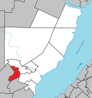
Lac-Pikauba is an unorganized territory in the Capitale-Nationale region of Quebec, Canada. It is a large, unpopulated, undeveloped territory that makes up two-thirds of the Charlevoix Regional County Municipality.

The Rivière du Premier Rang is a tributary of the west bank of the Jean-Noël River flowing on the north bank of the Saint Lawrence River, in the municipalities of Saint-Hilarion and Les Éboulements, in the MRC of Charlevoix Regional County Municipality, in the administrative region of Capitale-Nationale, in the province of Quebec, in Canada.

The Jean-Noël River is a tributary of the north shore of the Saint Lawrence River, in the administrative region of Capitale-Nationale, in the province of Quebec, in Canada. This river flows through the regional county municipalities (MRC) of:

The Armand-Jude River is a tributary of the north bank of the rivière du Seigneur on the northwest bank of the Saint Lawrence river. This stream flows in the municipality of Les Éboulements, in the Charlevoix Regional County Municipality, in the administrative region of Capitale-Nationale, in the province of Quebec, in Canada.

The Chicago River is a tributary of the east bank of the middle part of the Rivière du Gouffre, flowing in the administrative region of Capitale-Nationale, in the province from Quebec, to Canada. The course of this river flows through the regional county municipalities (MRCs) of:

References

  1. "Reference number 56727 in Banque de noms de lieux du Québec". toponymie.gouv.qc.ca (in French). Commission de toponymie du Québec.
  2. 1 2 Ministère des Affaires municipales, des Régions et de l'Occupation du territoire - Répertoire des municipalités: Saint-Hilarion
  3. 1 2 "Saint-Hilarion census profile". Statistics Canada, 2011 Census of Population. 2007-03-13. Retrieved 2007-07-20.
  4. Saint-Hilarion - Répertoire des municipalités du Québec
  5. /fiche.aspx?no_seq=56727 Toponymy: Saint-Hilarion
  6. "Population and dwelling counts: Canada, provinces and territories, and census subdivisions (municipalities), Quebec". Statistics Canada. February 9, 2022. Retrieved August 29, 2022.
  7. Statistics Canada: 1996, 2001, 2006, 2011 census

See also