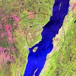
Charlevoix crater | |
Impact crater/structure | |
---|---|
Confidence | Confirmed |
Diameter | 54 km (34 mi) |
Age | 450 ± 20 Ma Ordovician to Silurian age [1] |
Exposed | Yes |
Drilled | Yes |
Bolide type | Stony meteorite |
Location | |
Coordinates | 47°32′N70°18′W / 47.533°N 70.300°W Coordinates: 47°32′N70°18′W / 47.533°N 70.300°W |
Country | Canada |
State | Quebec |
Municipality | Charlevoix |
The Charlevoix impact structure is a large eroded meteorite impact structure in the Charlevoix region of Quebec, Canada. [2] Only part of the impact structure is exposed at the surface, the rest lying beneath the Saint Lawrence River.
The original impact structure is estimated to have been 54 kilometres (34 mi) in diameter and the age of the impact is estimated to be 450 ± 20 million years (Ordovician to Silurian age). [1] The projectile was probably a stony asteroid, at least 2 kilometres (1.2 mi) in diameter, and weighing an estimated 15 billion tonnes (17 billion short tons ). The Mont des Éboulements, situated in the exact centre of the impact structure, is interpreted as the central uplift, a consequence of elastic rebound. [3] The impact structure is classified as a multi-ringed basin with a central uplift.
The impact origin of Charlevoix impact structure was first realized in 1965 after the discovery of many shatter cones in the area. Other evidence for impact includes planar deformation features (PDFs) in quartz and feldspar grains.
In contrast to the surrounding craggy Laurentian Mountains, the impact structure is relatively smooth and flat, which has facilitated human settlement. Today, 90% of the people of Charlevoix live within this impact structure. [3]
An impact crater is a depression in the surface of a planet, moon, or other solid body in the Solar System or elsewhere, formed by the hypervelocity impact of a smaller body. In contrast to volcanic craters, which result from explosion or internal collapse, impact craters typically have raised rims and floors that are lower in elevation than the surrounding terrain. Lunar impact craters range from microscopic craters on lunar rocks returned by the Apollo Program and small, simple, bowl-shaped depressions in the lunar regolith to large, complex, multi-ringed impact basins. Meteor Crater is a well-known example of a small impact crater on Earth.
An impact event is a collision between astronomical objects causing measurable effects. Impact events have physical consequences and have been found to regularly occur in planetary systems, though the most frequent involve asteroids, comets or meteoroids and have minimal effect. When large objects impact terrestrial planets such as the Earth, there can be significant physical and biospheric consequences, though atmospheres mitigate many surface impacts through atmospheric entry. Impact craters and structures are dominant landforms on many of the Solar System's solid objects and present the strongest empirical evidence for their frequency and scale.
Manicouagan Reservoir is an annular lake in central Quebec, Canada, covering an area of 1,942 km2 (750 sq mi). The lake island in its centre is known as René-Levasseur Island, and its highest point is Mount Babel. The structure was created 214 (±1) million years ago, in the Late Triassic, by the impact of a meteorite 5 km (3 mi) in diameter. The lake and island are clearly seen from space and are sometimes called the "eye of Quebec". The lake has a volume of 137.9 km3 (33.1 cu mi).
The Araguainha crater or Araguainha dome is an impact crater on the border of Mato Grosso and Goiás states, Brazil, between the villages of Araguainha and Ponte Branca. With a diameter of 40 kilometres (25 mi), it is the largest known impact crater in South America.
The Boltysh crater or Bovtyshka crater is a buried impact crater in the Kirovohrad Oblast of Ukraine, near the village of Bovtyshka. The crater is 24 kilometres (15 mi) in diameter and its age of 65.39 ± 0.14/0.16 million years, based on argon-argon dating techniques, less than 1 million years younger than Chicxulub crater in Mexico and the Cretaceous–Paleogene boundary. The Chicxulub impact is believed to have caused the mass extinction at the end of the Cretaceous period, which included the extinction of the non-avian dinosaurs. Unlike the Chicxulub impact's effects, a 2021 study suggests that the Boltysh impact "did not factor into the apocalyptic die-off of the dinosaurs."
Lac Couture is a lake in Northern Quebec, Canada. It is located near Hudson Bay in the Kativik territory. The lake is approximately 150 meters deep.
Gow is an impact crater in Saskatchewan, Canada.
The Kentland structure, also known as the Kentland crater or the Kentland disturbed area, is an impact structure located near the town of Kentland in Newton County, Indiana, United States.
Mistastin crater is a meteorite crater in Labrador, Canada which contains the roughly circular Mistastin Lake. The lake is approximately 16 km (9.9 mi) in diameter, while the estimated diameter of the original crater is 28 km (17 mi). The age of the crater is calculated to be 36.6 ± 2 million years (Eocene).
Oasis is a meteorite crater in Libya. The crater is exposed at the surface, and has been significantly eroded. The prominent topographic ring is only the central uplift, which is about 5.2 km (~3 miles) in diameter, while the original crater rim is estimated to have been 18 km (~11 miles) in diameter. The age is estimated to be less than 120 million years.
Presqu'île is a meteorite crater in the territory equivalent to a regional county municipality (TE) of Jamésie in the Nord-du-Québec region of Quebec, Canada, located about 3 kilometres (2 mi) south of the city of Chapais.
Puchezh-Katunki is a meteor crater located in the Nizhny Novgorod Oblast of the Volga Federal District, Russia. It is 80 km (50 mi) in diameter. Argon–argon dating has constrained the age of formation to be 195.9 ± 1.0 million years old, placing it within the Sinemurian stage of the Early Jurassic. The crater is not exposed to the surface, but appears as variation in the vegetation. The Earth Impact Database lists a rim-to-rim diameter of 40 kilometres (25 mi).
Rochechouart crater is an impact crater in France. The initial crater shape and structure has been lost by erosion and there is no crater visible on site; therefore it is more accurately described as Rochechouart impact structure.
The Vredefort crater is the largest verified impact crater on Earth. It was 160–300 km (100–200 mi) across when it was formed; and what remains of it is in the present-day Free State province of South Africa. It is named after the town of Vredefort, which is near its centre. Although the crater itself has long since been eroded away, the remaining geological structures at its centre are known as the Vredefort Dome or Vredefort impact structure. The crater is calculated to be 2.023 billion years old, with impact being in the Paleoproterozoic Era. It is the second-oldest known crater on Earth, after Yarrabubba crater.
Woodleigh is a large meteorite impact crater (astrobleme) in Western Australia, centred on Woodleigh Station east of Shark Bay, Gascoyne region. A team of four scientists at the Geological Survey of Western Australia and the Australian National University, led by Arthur J. Mory, announced the discovery in the 15 April 2000 issue of Earth and Planetary Science Letters.
Kebira Crater is the name given to a circular topographic feature that was identified in 2007 by Farouk El-Baz and Eman Ghoneim using satellite imagery, Radarsat-1, and Shuttle Radar Topography Mission (SRTM) data in the Sahara desert. This feature straddles the border between Egypt and Libya. The name of this feature is derived from the Arabic word for "large", and also from its location near the Gilf Kebir region in southwest Egypt. Based solely on their interpretations of the remote sensing data, they argue that this feature is an exceptionally large, double-ringed, extraterrestrial impact crater. They suggest that the crater's original appearance has been obscured by wind and water erosion over time. Finally, they speculated that this feature might be the source of the yellow-green silica glass fragments, known as "Libyan desert glass", that can be found across part of Egypt's Libyan Desert. They neither conducted any fieldwork at this feature nor studied any samples collected from it. However, the Kebira Crater is currently not listed in the Earth Impact Database. Field trips to investigate the feature have found no supporting evidence. The "central uplift" clearly retains the horizontal bedding of the surrounding sandstone tableland, providing clear evidence against a possible impact origin.
The Lac Wiyâshâkimî, also called the Clearwater Lakes in English, is a calque of Wiyâšâkamî in Northern East Cree and Allait Qasigialingat by the Inuit, are a pair of annular lakes on the Canadian Shield in Quebec, Canada, near Hudson Bay.
Complex craters are a type of large impact crater morphology.
The Corossol structure, which is also known as the Corossol crater, is a circular, 4.3-by-3.9-kilometre in diameter, underwater bedrock feature that is exposed on the gulf floor of the northwestern Gulf of Saint Lawrence 20-kilometre (12 mi) offshore of the city of Sept-Îles, Quebec in eastern Canada. It is hypothesized to be a possible pre-Pleistocene, extraterrestrial impact structure. It lies underwater at a depth of 40–208-metre (131–682 ft). This underwater feature was found during the study of high-resolution bathymetric and sub-bottom profiler data collected south of the city of Sept-Iles in the northwestern Gulf of Saint Lawrence.