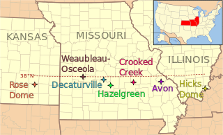
List of impact structures in Antarctica

Last updated

Map all coordinates using: OpenStreetMap

This List of impact structures in Antarctica includes only unconfirmed and theoretical impact sites in Antarctica and the surrounding waters of the Southern Ocean. There are not yet any confirmed impact sites in Antarctica according to the Earth Impact Database.

Contents

Unconfirmed impact structures

The following craters are officially considered "unconfirmed" because they are not listed in the Earth Impact Database. Due to stringent requirements regarding evidence and peer-reviewed publication, newly discovered craters or those with difficulty collecting evidence generally are known for some time before becoming listed. However, entries on the unconfirmed list could still have an impact origin disproven.

Antarctica Antarctica (orthographic projection).svg
Antarctica
NameLocationDiameterAgeCoordinatesSource
Bowers Antarctica 100 kmunknown 71°12′S176°00′E / 71.2°S 176°E / -71.2; 176 (Bowers) IFSG [1]
Ross Antarctica 550 kmOligocene 77°30′S178°30′E / 77.5°S 178.5°E / -77.5; 178.5 (Ross) IFSG [1]
Wilkes Land Wilkes Land, Antarctica 485 km<500 million? 70°S120°E / 70°S 120°E / -70; 120 (Wilkes Land) see article

See also

Related Research Articles

<span class="mw-page-title-main">Impact event</span> Collision of two astronomical objects

An impact event is a collision between astronomical objects causing measurable effects. Impact events have physical consequences and have been found to regularly occur in planetary systems, though the most frequent involve asteroids, comets or meteoroids and have minimal effect. When large objects impact terrestrial planets such as the Earth, there can be significant physical and biospheric consequences, as the impacting body is usually traveling at several kilometres a second, though atmospheres mitigate many surface impacts through atmospheric entry. Impact craters and structures are dominant landforms on many of the Solar System's solid objects and present the strongest empirical evidence for their frequency and scale.

<span class="mw-page-title-main">Rochechouart impact structure</span> Asteroid impact structure in France

Rochechouart impact structure or Rochechouart astrobleme is an impact structure in France. Erosion has over the millions of years mostly destroyed its impact crater, the initial surface expression of the asteroid impact leaving highly deformed bedrock and fragments of the crater's floor as evidence of it.

<span class="mw-page-title-main">Roter Kamm crater</span>

Roter Kamm is a meteorite crater, located in the Sperrgebiet, within the Namibian section of the Namib Desert, approximately 80 kilometres (50 mi) north of Oranjemund and 12 kilometres (7.5 mi) southwest of Aurus Mountain in the ǁKaras Region. The crater is 2.5 kilometres (1.6 mi) in diameter and is 130 metres (430 ft) deep. The age is estimated at 4.81 ± 0.5 Ma, placing it in the Pliocene. The crater is exposed at the surface, but its original floor is covered by sand deposits at least 100 metres (330 ft) thick.

<span class="mw-page-title-main">Strangways crater</span> Impact crater of Northern Territory

Strangways is a large impact structure, the eroded remnant of a former impact crater, located in the Northern Territory of Australia about 65 kilometres (40 mi) east-south-east of the town of Mataranka. It was named after the nearby Strangways River. The location is remote and difficult to access. Its age has been determined as approximately 646 Ma.

<span class="mw-page-title-main">Kebira Crater</span> Circular feature in the Sahara

Kebira Crater is the name given to a circular topographic feature that was identified in 2007 by Farouk El-Baz and Eman Ghoneim using satellite imagery, Radarsat-1, and Shuttle Radar Topography Mission (SRTM) data in the Sahara desert. This feature straddles the border between Egypt and Libya. The name of this feature is derived from the Arabic word for "large", and also from its location near the Gilf Kebir region in southwest Egypt. Based solely on their interpretations of the remote sensing data, they argue that this feature is an exceptionally large, double-ringed, extraterrestrial impact crater. They suggest that the crater's original appearance has been obscured by wind and water erosion over time. Finally, they speculated that this feature might be the source of the yellow-green silica glass fragments, known as "Libyan desert glass", that can be found across part of Egypt's Libyan Desert. They neither conducted any fieldwork at this feature nor studied any samples collected from it. However, the Kebira Crater is currently not listed in the Earth Impact Database. Field trips to investigate the feature have found no supporting evidence. The "central uplift" clearly retains the horizontal bedding of the surrounding sandstone tableland, providing clear evidence against a possible impact origin.

Wilkes Land crater is an informal term that may apply to two separate cases of conjectured giant impact craters hidden beneath the ice cap of Wilkes Land, East Antarctica. These are separated below under the heading Wilkes Land anomaly and Wilkes Land mascon (mass concentration), based on terms used in their principal published reference sources.

<span class="mw-page-title-main">Impact structure</span> Geologic structure formed from impact on a planetary surface

An impact structure is a generally circular or craterlike geologic structure of deformed bedrock or sediment produced by impact on a planetary surface, whatever the stage of erosion of the structure. In contrast, an impact crater is the surface expression of an impact structure. In many cases, on Earth, the impact crater has been destroyed by erosion, leaving only the deformed rock or sediment of the impact structure behind. This is the fate of almost all old impact craters on Earth, unlike the ancient pristine craters preserved on the Moon and other geologically inactive rocky bodies with old surfaces in the Solar System. Impact structure is synonymous with the less commonly used term astrobleme meaning "star wound".

<span class="mw-page-title-main">Earth Impact Database</span> Database of impact structures on Earth

The Earth Impact Database is a database of confirmed impact structures or craters on Earth. It was initiated in 1955 by the Dominion Observatory, Ottawa, under the direction of Carlyle S. Beals. Since 2001, it has been maintained as a not-for-profit source of information at the Planetary and Space Science Centre at the University of New Brunswick, Canada.

The Victoria Island structure is a 5.5 km (3 mi) bowl-shaped structure buried in the shale sediments of the Sacramento-San Joaquin River Delta, 12 miles (19 km) west of Stockton, California. The circular structure is part of a former sea bed, and lies 1,490–1,600 meters (4,890–4,250 ft) below sea level.

<span class="mw-page-title-main">Ramgarh crater</span> Impact crater in the country of India

Ramgarh crater, also known as Ramgarh structure, Ramgarh Dome and Ramgarh astrobleme, is a meteor impact crater of 3.5 kilometres (2.2 mi) diameter in Kota plateau of Vindhya range located adjacent to Ramgarh village in Mangrol tehsil of Baran district in Rajasthan state of India. When formally accepted as the third crater in India, its diameter size would be between the two already confirmed craters in India - Dhala in Madhya Pradesh with 14 km diameter and Lonar in Buldhana district of Maharashtra with 1.8 km diameter.

The Impact Field Studies Group (IFSG) was a scientific organization emphasizing geologic field research of suspected and confirmed sites of impact craters and impact structures. The group is composed of researchers, professionals and students involved in study of impact sites. IFSG's web site is hosted by the Department of Earth and Planetary Sciences at University of Tennessee, Knoxville.

<i>Traces of Catastrophe</i> Book by Bevan M. French

Traces of Catastrophe: A Handbook of Shock-Metamorphic Effects in Terrestrial Meteorite Impact Structures is a book written by Bevan M. French of the Smithsonian Institution. It is a comprehensive technical reference on the science of impact craters. It was published in 1998 by the Lunar and Planetary Institute (LPI), which is part of the Universities Space Research Association (USRA). It was originally available in hard copy from LPI, but is now only available as a portable document format (PDF) e-book free download.

References

  1. 1 2 Rajmon, David (2009-07-01). "Impact Database" . Retrieved 2009-10-05.
Map all coordinates using: OpenStreetMap