List of impact structures in North America

Last updated

World map in equirectangular projection of the craters on the Earth Impact Database as of November 2017 (in the SVG file, hover over a crater to show its details) Earth Impact Database world map.svg
World map in equirectangular projection of the craters on the Earth Impact Database as of November 2017 (in the SVG file, hover over a crater to show its details)

This list includes all 60 confirmed impact structures in North America in the Earth Impact Database (EID). These features were caused by the collision of large meteorites or comets with the Earth. For eroded or buried craters, the stated diameter typically refers to an estimate of original rim diameter, and may not correspond to present surface features.

Contents

North America North America (orthographic projection).svg
North America

Canada

NameLocationDiameter (km)Age (Ma/millions)Coordinates
Brent Ontario 3.8396 ± 20 46°5′N78°29′W / 46.083°N 78.483°W / 46.083; -78.483 (Brent)
Carswell Saskatchewan 39115 ± 10 58°27′N109°30′W / 58.450°N 109.500°W / 58.450; -109.500 (Carswell)
Charlevoix Quebec 54342 ± 15 47°32′N70°18′W / 47.533°N 70.300°W / 47.533; -70.300 (Charlevoix)
Couture Quebec 8430 ± 25 60°8′N75°20′W / 60.133°N 75.333°W / 60.133; -75.333 (Couture)
Deep Bay Saskatchewan 1399 ± 4 56°24′N102°59′W / 56.400°N 102.983°W / 56.400; -102.983 (Deep Bay)
Eagle Butte Alberta 10< 65 49°42′N110°30′W / 49.700°N 110.500°W / 49.700; -110.500 (Eagle Butte)
Elbow Saskatchewan 8395 ± 25 50°59′N106°43′W / 50.983°N 106.717°W / 50.983; -106.717 (Elbow)
Gow Saskatchewan 4< 250 56°27′N104°29′W / 56.450°N 104.483°W / 56.450; -104.483 (Gow)
Haughton Nunavut 2339 75°23′N89°40′W / 75.383°N 89.667°W / 75.383; -89.667 (Haughton)
Holleford Ontario 2.35550 ± 100 44°28′N76°38′W / 44.467°N 76.633°W / 44.467; -76.633 (Holleford)
Île Rouleau Quebec 4< 300 50°41′N73°53′W / 50.683°N 73.883°W / 50.683; -73.883 (Île Rouleau)
La Moinerie Quebec 8400 ± 50 57°26′N66°37′W / 57.433°N 66.617°W / 57.433; -66.617 (La Moinerie)
Lac à l'Eau Claire Est
Clearwater East
Quebec 26460–470 56°04′N74°06′W / 56.067°N 74.100°W / 56.067; -74.100 (Lac à l'Eau Claire Est)
Lac à l'Eau Claire Ouest
Clearwater West
Quebec 36286.2 ± 2.6 56°13′N74°30′W / 56.217°N 74.500°W / 56.217; -74.500 (Lac à l'Eau Claire Ouest)
Manicouagan Quebec 100214 ± 1 51°23′N68°42′W / 51.383°N 68.700°W / 51.383; -68.700 (Manicouagan)
Maple Creek Saskatchewan 6< 75 49°48′N109°6′W / 49.800°N 109.100°W / 49.800; -109.100 (Maple Creek)
Mistastin Newfoundland and Labrador 2836.4 ± 4 55°53′N63°18′W / 55.883°N 63.300°W / 55.883; -63.300 (Mistastin)
Montagnais Nova Scotia 4550.50 ± 0.76 42°53′N64°13′W / 42.883°N 64.217°W / 42.883; -64.217 (Montagnais)
Nicholson Northwest Territories 12.5< 400 62°40′N102°41′W / 62.667°N 102.683°W / 62.667; -102.683 (Nicholson)
Pilot Northwest Territories 6445 ± 2 60°17′N111°0′W / 60.283°N 111.000°W / 60.283; -111.000 (Pilot)
Pingualuit
formerly Chubb and Nouveau-Québec
Quebec 3.441.4 ± 0.1 61°17′N73°40′W / 61.283°N 73.667°W / 61.283; -73.667 (Pingualuit)
Presqu'île Quebec 24< 500 49°43′N74°48′W / 49.717°N 74.800°W / 49.717; -74.800 (Presqu'île)
Tunnunik Northwest Territories 25~130-350 72°28′N113°56′W / 72.467°N 113.933°W / 72.467; -113.933 [1]
Saint Martin Manitoba 40220 ± 32 51°47′N98°32′W / 51.783°N 98.533°W / 51.783; -98.533 (Saint Martin)
Slate Islands Ontario 30about 450 48°40′N87°0′W / 48.667°N 87.000°W / 48.667; -87.000 (Slate Islands)
Steen River Alberta 2591 ± 7 59°30′N117°38′W / 59.500°N 117.633°W / 59.500; -117.633 (Steen River)
Sudbury Ontario 2501850 ± 3 46°36′N81°11′W / 46.600°N 81.183°W / 46.600; -81.183 (Sudbury)
Viewfield Saskatchewan 2.5190 ± 20 49°35′N103°4′W / 49.583°N 103.067°W / 49.583; -103.067 (Viewfield)
Wanapitei Ontario 7.537.2 ± 1.2 46°45′N80°45′W / 46.750°N 80.750°W / 46.750; -80.750 (Wanapitei)
West Hawk Manitoba 2.44351 ± 20 49°46′N95°11′W / 49.767°N 95.183°W / 49.767; -95.183 (West Hawk)
Whitecourt Alberta 0.04<0.0011 54°00′N115°36′W / 54.000°N 115.600°W / 54.000; -115.600 (Whitecourt)

Mexico

NameLocationDiameter (km)Age (Ma/millions)Coordinates
Chicxulub Yucatan 17064.98 ± 0.05 21°20′N89°30′W / 21.333°N 89.500°W / 21.333; -89.500 (Chicxulub)

United States

NameLocationDiameter (km)Age (Ma/millions)Coordinates
Ames Oklahoma 16470 ± 30 36°15′N98°12′W / 36.250°N 98.200°W / 36.250; -98.200 (Ames)
Avak Alaska 12< 95 71°15′N156°30′W / 71.250°N 156.500°W / 71.250; -156.500 (Avak)
Barringer Arizona 1.190.049 ± 0.003 35°2′N111°1′W / 35.033°N 111.017°W / 35.033; -111.017 (Barringer)
Beaverhead Idaho, Montana 60600 44°15′N114°0′W / 44.250°N 114.000°W / 44.250; -114.000 (Beaverhead)
Calvin Michigan 8.5450 ± 10 41°50′N85°57′W / 41.833°N 85.950°W / 41.833; -85.950 (Calvin)
Chesapeake Bay Virginia 9035.5 ± 0.3 37°17′N76°1′W / 37.283°N 76.017°W / 37.283; -76.017 (Chesapeake Bay)
Cloud Creek Wyoming 7190 ± 30 43°7′N106°45′W / 43.117°N 106.750°W / 43.117; -106.750 (Cloud Creek)
Crooked Creek Missouri 7320 ± 80 37°50′N91°23′W / 37.833°N 91.383°W / 37.833; -91.383 (Crooked Creek)
Decaturville Missouri 6< 300 37°54′N92°43′W / 37.900°N 92.717°W / 37.900; -92.717 (Decaturville)
Des Plaines Illinois 8< 280 42°3′N87°52′W / 42.050°N 87.867°W / 42.050; -87.867 (Des Plaines)
Flynn Creek Tennessee 3.8360 ± 20 36°17′N85°40′W / 36.283°N 85.667°W / 36.283; -85.667 (Flynn Creek)
Glasford Illinois 4< 430 40°36′N89°47′W / 40.600°N 89.783°W / 40.600; -89.783 (Glasford)
Glover Bluff Wisconsin 8< 500 43°58′N89°32′W / 43.967°N 89.533°W / 43.967; -89.533 (Glover Bluff)
Haviland Kansas 0.015< 0.001 37°35′N99°10′W / 37.583°N 99.167°W / 37.583; -99.167 (Haviland)
Kentland Indiana 13< 97 40°45′N87°24′W / 40.750°N 87.400°W / 40.750; -87.400 (Kentland)
Manson Iowa 3573.8 ± 0.3 42°35′N94°33′W / 42.583°N 94.550°W / 42.583; -94.550 (Manson)
Marquez Texas 12.758 ± 2 31°17′N96°18′W / 31.283°N 96.300°W / 31.283; -96.300 (Marquez)
Middlesboro Kentucky 6< 300 36°37′N83°44′W / 36.617°N 83.733°W / 36.617; -83.733 (Middlesboro)
Newporte North Dakota 3.2< 500 48°58′N101°58′W / 48.967°N 101.967°W / 48.967; -101.967 (Newporte)
Odessa Texas 0.168< 0.050 31°45′N102°29′W / 31.750°N 102.483°W / 31.750; -102.483 (Odessa)
Red Wing North Dakota 9200 ± 25 47°36′N103°33′W / 47.600°N 103.550°W / 47.600; -103.550 (Red Wing)
Rock Elm Wisconsin 6< 505 44°43′N92°14′W / 44.717°N 92.233°W / 44.717; -92.233 (Rock Elm)
Santa Fe New Mexico 6-13<1200 35°45′N105°56′W / 35.750°N 105.933°W / 35.750; -105.933 (Santa Fe)
Serpent Mound Ohio 8< 320 39°2′N83°24′W / 39.033°N 83.400°W / 39.033; -83.400 (Serpent Mound)
Sierra Madera Texas 13< 100 30°36′N102°55′W / 30.600°N 102.917°W / 30.600; -102.917 (Sierra Madera)
Upheaval Dome Utah 10< 170 38°26′N109°56′W / 38.433°N 109.933°W / 38.433; -109.933 (Upheaval Dome)
Wells Creek Tennessee 12200 ± 100 36°23′N87°40′W / 36.383°N 87.667°W / 36.383; -87.667 (Wells Creek)
Wetumpka Alabama 7.6~83 32°31′N86°10′W / 32.517°N 86.167°W / 32.517; -86.167 (Wetumpka) [2] [3]

Unconfirmed impact structures

The following craters are officially considered "unconfirmed" because they are not listed in the Earth Impact Database. Due to stringent requirements regarding evidence and peer-reviewed publication, newly discovered craters or those with difficulty collecting evidence generally are known for some time before becoming listed. However, entries on the unconfirmed list could still have an impact origin disproven.

NameLocationDiameter (km)Age (years)CoordinatesProbability
Alamo bolide impact Nevada unknown367 million
Bow City Alberta 8 km70 million 50°25′N112°16′W / 50.417°N 112.267°W / 50.417; -112.267 (Bow City)
Corossol Quebec 4 km2.6 million 50°03′N66°23′W / 50.050°N 66.383°W / 50.050; -66.383 (Corossol)
Decorah crater Iowa 5.6470 million 43°18′49.73″N91°46′20.04″W / 43.3138139°N 91.7722333°W / 43.3138139; -91.7722333 2 (probable) [4] [5]
Gatun structure Panama 2.73.020 million 09°06′N79°47′W / 9.100°N 79.783°W / 9.100; -79.783 (Gatun structure) 2 (probable) [6]
Pantasma Nicaragua 101 million 13°22′N85°57′W / 13.37°N 85.95°W / 13.37; -85.95 (Pantasma) 4 (not probable) [6]
Jeptha Knob Kentucky 4.3425 million 38°11′N85°07′W / 38.183°N 85.117°W / 38.183; -85.117 (Jeptha Knob) 2 (probable) [6]
Panther Mountain New York state 10375 million 42°03′N74°24′W / 42.050°N 74.400°W / 42.050; -74.400 (Panther Mountain) 2 (probable) [6]
Snows Island South Carolina 11unknown 33°49′N79°22′W / 33.817°N 79.367°W / 33.817; -79.367 (Snows Island) 2 (probable) [6]
Toms Canyon New Jersey 2235 million 39°08′N72°51′W / 39.133°N 72.850°W / 39.133; -72.850 (Toms Canyon) 2 (probable) [6]
Victoria Island structure California 5.53749 million 37°53′24″N121°32′05″W / 37.889925°N 121.534672°W / 37.889925; -121.534672 (Victoria Island structure) [7] 2 (probable) [6]
Weaubleau-Osceola Missouri 15–20325.0 ± 15.0 million 37°59′N93°38′W / 37.983°N 93.633°W / 37.983; -93.633 (Weaubleau-Osceola) 2 (probable) [6]
Brushy Creek Feature Louisiana 211,000 - 30,000 years 30°46′05″N90°44′06″W / 30.768°N 90.735°W / 30.768; -90.735 (Brushy Creek Feature) 2 (probable). [8] [9] [10]

See also

Related Research Articles

<span class="mw-page-title-main">Amguid crater</span> Meteorite crater in Algeria

Amguid is a meteorite crater in Algeria.

<span class="mw-page-title-main">Middlesboro crater</span> Impact crater in Kentucky

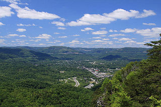
The Middlesboro crater is a meteorite crater in Kentucky, United States. It is named after the city of Middlesborough, which today occupies much of the crater.

<span class="mw-page-title-main">Neugrund crater</span> Meteorite crater in Estonia

Neugrund is a meteorite crater in Estonia. It is 8 km (5.0 mi) in diameter and was previously estimated to have been formed in the Ordovician around 470 Ma, with later research revealing a possible Cambrian origin. The crater is at the bottom of the sea and is not exposed at the surface. Boulders of gneissic breccia found on the coast of Osmussaar, a nearby island, are believed to have been thrown there by the explosion. It has been proposed that the Neugrund crater was created during the Ordovician meteor event when a hypothetical large asteroid transferred directly into a resonant orbit with Jupiter, which shifted its orbit to intercept Earth.

<span class="mw-page-title-main">Roter Kamm crater</span> Meteorite crater in the Namibian section of the Namib Desert

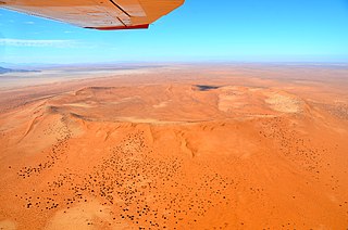
Roter Kamm is a meteorite crater, located in the Sperrgebiet, within the Namibian section of the Namib Desert, approximately 80 kilometres (50 mi) north of Oranjemund and 12 kilometres (7.5 mi) southwest of Aurus Mountain in the ǁKaras Region. The crater is 2.5 kilometres (1.6 mi) in diameter and is 130 metres (430 ft) deep. The age is estimated at 4.81 ± 0.5 Ma, placing it in the Pliocene. The crater is exposed at the surface, but its original floor is covered by sand deposits at least 100 metres (330 ft) thick.

<span class="mw-page-title-main">Wetumpka crater</span> Impact crater in Alabama

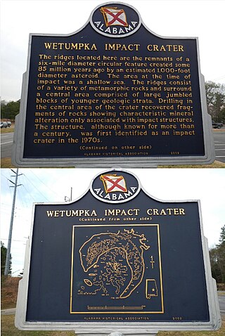
The Wetumpka impact crater is the only confirmed impact crater in Alabama, United States. It is located east of downtown Wetumpka in Elmore County. The crater is 4.7 miles (7.6 km) in diameter, and its age is estimated to be about 85 million years, based on fossils found in the youngest disturbed deposits, which belong to the Mooreville Chalk Formation.

<span class="mw-page-title-main">38th parallel structures</span> American Midwest landscape depressions

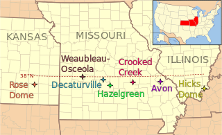
The 38th parallel structures, also known as the 38th parallel lineament, are a series of seven circular depressions or deformations stretching 700 kilometres (430 mi) across southern Illinois and Missouri and into eastern Kansas, in the United States, at a latitude of roughly 38 degrees north. Estimated at 300 million years old, two are believed to be impact events from meteorites, but other structures are possibly remnants of volcanos.

<span class="mw-page-title-main">Kebira Crater</span> Circular feature in the Sahara

Kebira Crater is the name given to a circular topographic feature that was identified in 2007 by Farouk El-Baz and Eman Ghoneim using satellite imagery, Radarsat-1, and Shuttle Radar Topography Mission (SRTM) data in the Sahara desert. This feature straddles the border between Egypt and Libya. The name of this feature is derived from the Arabic word for "large", and also from its location near the Gilf Kebir region in southwest Egypt. Based solely on their interpretations of the remote sensing data, they argue that this feature is an exceptionally large, double-ringed, extraterrestrial impact crater. They suggest that the crater's original appearance has been obscured by wind and water erosion over time. Finally, they speculated that this feature might be the source of the yellow-green silica glass fragments, known as "Libyan desert glass", that can be found across part of Egypt's Libyan Desert. They neither conducted any fieldwork at this feature nor studied any samples collected from it. However, the Kebira Crater is currently not listed in the Earth Impact Database. Field trips to investigate the feature have found no supporting evidence. The "central uplift" clearly retains the horizontal bedding of the surrounding sandstone tableland, providing clear evidence against a possible impact origin.

<span class="mw-page-title-main">Earth Impact Database</span> Database of impact structures on Earth

The Earth Impact Database is a database of confirmed impact structures or craters on Earth. It was initiated in 1955 by the Dominion Observatory, Ottawa, under the direction of Carlyle S. Beals. Since 2001, it has been maintained as a not-for-profit source of information at the Planetary and Space Science Centre at the University of New Brunswick, Canada.

<span class="mw-page-title-main">Ramgarh crater</span> Impact crater in the country of India

Ramgarh crater, also known as Ramgarh structure, Ramgarh Dome and Ramgarh astrobleme, is a meteor impact crater of 3.5 kilometres (2.2 mi) diameter in Kota plateau of Vindhya range located adjacent to Ramgarh village in Mangrol tehsil of Baran district in Rajasthan state of India. When formally accepted as the third crater in India, its diameter size would be between the two already confirmed craters in India - Dhala in Madhya Pradesh with 14 km diameter and Lonar in Buldhana district of Maharashtra with 1.8 km diameter.

The Impact Field Studies Group (IFSG) was a scientific organization emphasizing geologic field research of suspected and confirmed sites of impact craters and impact structures. The group is composed of researchers, professionals and students involved in study of impact sites. IFSG's web site is hosted by the Department of Earth and Planetary Sciences at University of Tennessee, Knoxville.

<i>Traces of Catastrophe</i> Book by Bevan M. French

Traces of Catastrophe: A Handbook of Shock-Metamorphic Effects in Terrestrial Meteorite Impact Structures is a book written by Bevan M. French of the Smithsonian Institution. It is a comprehensive technical reference on the science of impact craters. It was published in 1998 by the Lunar and Planetary Institute (LPI), which is part of the Universities Space Research Association (USRA). It was originally available in hard copy from LPI, but is now only available as a portable document format (PDF) e-book free download.

The Tunnunik impact crater, formerly known as the Prince Albert Impact Crater, is a recently confirmed meteorite impact crater. It is located on Prince Albert Peninsula in the northwestern part of Victoria Island in Canada's Northwest Territories.

References

  1. July 25, 2012. "Researchers discover new impact crater in the Arctic," Archived 2013-02-25 at the Wayback Machine University of Saskatchewan, Accessed August 8, 2012. NOTE: Geographic coordinates are in the comments section.
  2. King Jr., David T. (April 23, 2010). "Wetumpka Crater". The Encyclopedia of Alabama. Alabama Humanities Foundation. Archived from the original on February 16, 2012. Retrieved February 7, 2013.
  3. "Wetumpka's Coastal Impact Crater". City of Wetumpka. Retrieved February 7, 2013.
  4. Vastag, Brian (18 February 2013). "Crater found in Iowa points to asteroid break-up 470 million years ago". Washington Post . Retrieved 19 February 2013.
  5. U.S. Geological Survey. "Iowa Meteorite Crater Confirmed" . Retrieved 7 March 2013.
  6. 1 2 3 4 5 6 7 8 Rajmon, David (October 10, 2009). "Impact Database 2009.2" (Excel). Impact Field Studies Group . Retrieved December 28, 2009.[ permanent dead link ]
  7. "Victoria Island". Geographic Names Information System . United States Geological Survey, United States Department of the Interior.
  8. Heinrich, P.V. (2003) Possible Meteorite Impact Crater in St. Helena Parish, Louisiana. Search and Discovery Article. no. 50006. American Association of Petroleum Geologist, Tulsa, Oklahoma. Retrieved March 27, 2011.
  9. Heinrich, P.V. (2003) Origin of a Circular Depression and Associated Fractured and Shocked Quartz, St. Helena Parish, LA. Transactions of the Gulf Association of Geological Societies. vol. 53, pp. 313-322.
  10. Anonymous, 2008, LGS Researcher Featured in Meteor Crater News Story. Archived 2012-03-21 at the Wayback Machine Center for Energy Studies, Louisiana State University Baton Rouge, LA 70803. Retrieved March 27, 2011.