An impact crater is a circular depression in the surface of a solid astronomical object formed by the hypervelocity impact of a smaller object. In contrast to volcanic craters, which result from explosion or internal collapse, impact craters typically have raised rims and floors that are lower in elevation than the surrounding terrain. Lunar impact craters range from microscopic craters on lunar rocks returned by the Apollo program and small, simple, bowl-shaped depressions in the lunar regolith to large, complex, multi-ringed impact basins. Meteor Crater is a well-known example of a small impact crater on Earth.

The Chicxulub crater is an impact crater buried underneath the Yucatán Peninsula in Mexico. Its center is offshore, but the crater is named after the onshore community of Chicxulub Pueblo. It was formed slightly over 66 million years ago when a large asteroid, about ten kilometers in diameter, struck Earth. The crater is estimated to be 180 kilometers in diameter and 20 kilometers in depth. It is the second largest confirmed impact structure on Earth, and the only one whose peak ring is intact and directly accessible for scientific research.
The Chesapeake Bay impact crater is a buried impact crater, located beneath the mouth of Chesapeake Bay, United States. It was formed by a bolide that struck the eastern shore of North America about 35.5 ± 0.3 million years ago, in the late Eocene epoch. It is one of the best-preserved "wet-target" impact craters in the world.

Manicouagan Reservoir is an annular lake in central Quebec, Canada, covering an area of 1,942 km2 (750 sq mi). The lake island in its centre is known as René-Levasseur Island, and its highest point is Mount Babel. The structure was created 214 (±1) million years ago, in the Late Triassic, by the impact of a meteorite 5 km (3 mi) in diameter. The lake and island are clearly seen from space and are sometimes called the "eye of Quebec". The lake has a volume of 137.9 km3 (33.1 cu mi).

Impactite is rock created or modified by one or more impacts of a meteorite. Impactites are considered metamorphic rock, because their source materials were modified by the heat and pressure of the impact. On Earth, impactites consist primarily of modified terrestrial material, sometimes with pieces of the original meteorite.
Cloud Creek crater is an impact crater in Wyoming, United States. The crater is located in Natrona County, about 48 miles (77 km) northwest of Casper, near the center of a geological feature known as the Casper Arch.

Keurusselkä is a lake in Central Finland between the towns of Keuruu to the north and Mänttä to the south. It covers an area of 117.3 km2 (45.3 sq mi). Its average depth is 6.4 m (21 ft) with a maximum depth of 40 m (130 ft). The surface lies at 105.4 m (346 ft) above sea level. The lake is 27 km (17 mi) long and is a part of the Kokemäenjoki water system. Keurusselkä gained international publicity in 2004 when a pair of amateur geologists discovered an ancient impact crater on the western shore of the lake.
Maple Creek is a subterranean meteorite crater in Saskatchewan, Canada. It is 6 km (3.7 mi) in diameter and the age is estimated to be less than 75 million years. The crater is buried beneath younger sediments and cannot be seen at the surface.
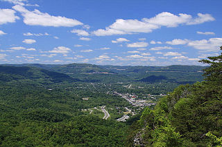
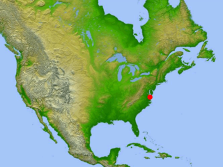
The Middlesboro crater is a meteorite crater in Kentucky, United States. It is named after the city of Middlesborough, which today occupies much of the crater.
Red Wing or Red Wing Creek structure is a meteor crater located in McKenzie County, North Dakota, about 24 km (15 mi) southwest of Watford City, North Dakota, United States.
Viewfield is an impact crater in Saskatchewan, Canada.

Wells Creek is an impact crater located near Cumberland City, Tennessee. It is 12 kilometers (7.5 mi) in diameter and the age is estimated to be 200±100 Ma, placing it in the Jurassic or a neighboring period. The crater is exposed to the surface. The center of the crater contains some of the finest shatter cones in the world. Many have been collected and are on display around the world.

The Manson crater is an impact crater near the site of Manson, Iowa where an asteroid or comet nucleus struck the Earth during the Cretaceous Period, approximately 74 Ma. It was one of the largest known impact events to have happened in North America. Previously it was thought to have led to the extinction of the dinosaurs until isotopic ages proved that it was too old.
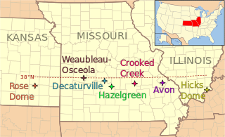
The 38th parallel structures, also known as the 38th parallel lineament, are a series of seven circular depressions or deformations stretching 700 kilometres (430 mi) across southern Illinois and Missouri and into eastern Kansas, in the United States, at a latitude of roughly 38 degrees north. Estimated at 300 million years old, two are believed to be impact events from meteorites, but other structures are possibly remnants of volcanos.
Crooked Creek may refer to:
Amelia Creek crater is an impact structure, the eroded remnant of a former impact crater, located in the Davenport Range, Northern Territory, Australia. It lies within a low range of Paleoproterozoic sedimentary and volcanic rocks, which are extensively folded and faulted, thus making an eroded impact crater difficult to recognize. It was only discovered by the identification of shatter cones near its centre. The central shatter cone locality is surrounded by a 20 by 12 km area of anomalous deformation, the asymmetry being possibly related to very oblique impact, but may be at least partly due to the preexisting structural complexity of the rocks. This deformed zone gives the best estimate for the original size of the crater. Impact took place after folding of the Paleoproterozoic rocks but before deposition of Neoproterozoic and Cambrian rocks which overlie them, thus constraining the impact event to the interval between about 1660 and 600 Ma.

The flows of Jordan Craters volcanic field are the youngest of a series of large Quaternary basalt fields in the eastern part of the U.S. state of Oregon. The field is thought to be approximately 3200 years old, based on findings of a lake sediment coring experiment in 1986. It was formed by basaltic pahoehoe emanating from vents throughout the area.
The Impact Field Studies Group (IFSG) was a scientific organization emphasizing geologic field research of suspected and confirmed sites of impact craters and impact structures. The group is composed of researchers, professionals and students involved in study of impact sites. IFSG's web site is hosted by the Department of Earth and Planetary Sciences at University of Tennessee, Knoxville.
Bloody Creek crater, which is also known as the Bloody Creek structure, is a 420-by-350-meter in diameter elliptical feature that is located in southwestern Nova Scotia, Canada. It is argued to be either a possible extraterrestrial impact crater or an impact structure. It lies between Bridgetown and West Dalhousie, Annapolis County, Nova Scotia, where the Bloody Creek structure straddles what was once a stretch of Bloody Creek. It also is informally known as the Astrid crater.