An impact event is a collision between astronomical objects causing measurable effects. Impact events have been found to regularly occur in planetary systems, though the most frequent involve asteroids, comets or meteoroids and have minimal effect. When large objects impact terrestrial planets such as the Earth, there can be significant physical and biospheric consequences, as the impacting body is usually traveling at several kilometres a second, though atmospheres mitigate many surface impacts through atmospheric entry. Impact craters and structures are dominant landforms on many of the Solar System's solid objects and present the strongest empirical evidence for their frequency and scale.

The Witwatersrand is a 56-kilometre-long (35 mi), north-facing scarp in South Africa. It consists of a hard, erosion-resistant quartzite metamorphic rock, over which several north-flowing rivers form waterfalls, which account for the name Witwatersrand, meaning 'white water ridge' in Afrikaans. This east-west-running scarp can be traced with only one short gap, from Bedfordview in the east, through Johannesburg and Roodepoort, to Krugersdorp in the west.

Manicouagan Reservoir is an annular lake in central Quebec, Canada, covering an area of 1,942 km2 (750 sq mi). The lake island in its centre is known as René-Levasseur Island, and its highest point is Mount Babel. The structure was created 214 (±1) million years ago, in the Late Triassic, by the impact of a meteorite 5 km (3 mi) in diameter. The lake and island are clearly seen from space and are sometimes called the "eye of Quebec". The lake has a volume of 137.9 km3 (33.1 cu mi).
The Sudbury Basin, also known as Sudbury Structure or the Sudbury Nickel Irruptive, is a major geological structure in Ontario, Canada. It is the third-largest known impact structure on Earth, as well as one of the oldest. The structure, the eroded remnant of an impact crater, was formed by the impact of an asteroid 1.849 billion years ago in the Paleoproterozoic era.

Dalgaranga crater is a small meteorite impact crater located on Dalgaranga pastoral station 75 km (47 mi) northwest of Mount Magnet in Western Australia. It is only 24 m (79 ft) in diameter and 3 m (9.8 ft) deep, making it Australia's smallest impact crater. Though discovered in 1921, it was not reported in the scientific literature until 1938. The bedrock at the site is weathered Archaean granite of the Yilgarn Craton. The discovery of fragments of mesosiderite stony-iron meteorite around the crater confirms an impact origin, making this crater unique as the only one known to have been produced by a mesosiderite projectile.

Gosses Bluff is thought to be the eroded remnant of an impact crater. Known as Tnorala to the Western Arrernte people of the surrounding region, it is located in the southern Northern Territory, near the centre of Australia, about 175 km (109 mi) west of Alice Springs and about 212 km (132 mi) to the northeast of Uluru. It was named by Ernest Giles in 1872 after Australian explorer William Gosse's brother Henry, who was a member of William's expedition.

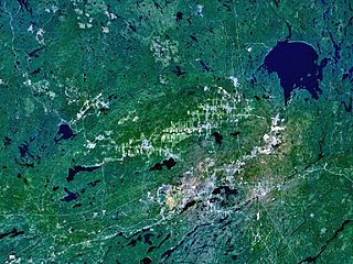
Keurusselkä is a lake in Central Finland between the towns of Keuruu to the north and Mänttä to the south. It covers an area of 117.3 km2 (45.3 sq mi). Its average depth is 6.4 m (21 ft) with a maximum depth of 40 m (130 ft). The surface lies at 105.4 m (346 ft) above sea level. The lake is 27 km (17 mi) long and is a part of the Kokemäenjoki water system. Keurusselkä gained international publicity in 2004 when a pair of amateur geologists discovered an ancient impact structure on the western shore of the lake.

Shoemaker is an impact structure, the deeply eroded remnant of a former impact crater, situated in arid central Western Australia, about 100 km (62 mi) north-northeast of Wiluna. It is named in honour of planetary geologist Eugene Shoemaker.

Strangways is a large impact structure, the eroded remnant of a former impact crater, located in the Northern Territory of Australia about 65 kilometres (40 mi) east-south-east of the town of Mataranka. It was named after the nearby Strangways River. The location is remote and difficult to access. Its age has been determined as approximately 646 Ma.
Suavjärvi is a lake in the Republic of Karelia, Russia about 50 km north of the town of Medvezhyegorsk. The lake is approximately 3 kilometers (1.9 mi) wide.

The Vredefort impact structure is the largest verified impact structure on Earth. The crater, which has since been eroded away, has been estimated at 170–300 kilometres (110–190 mi) across when it was formed. The remaining structure, comprising the deformed underlying bedrock, is located in present-day Free State province of South Africa. It is named after the town of Vredefort, which is near its centre. The structure's central uplift is known as the Vredefort Dome. The impact structure was formed during the Paleoproterozoic Era, 2.023 billion years ago. It is the second-oldest known impact structure on Earth, after Yarrabubba.

The Yilgarn Craton is a large craton that constitutes a major part of the Western Australian land mass. It is bounded by a mixture of sedimentary basins and Proterozoic fold and thrust belts. Zircon grains in the Jack Hills, Narryer Terrane have been dated at ~4.27 Ga, with one detrital zircon dated as old as 4.4 Ga.

The oldest dated rocks formed on Earth, as an aggregate of minerals that have not been subsequently broken down by erosion or melted, are more than 4 billion years old, formed during the Hadean Eon of Earth's geological history, and mark the start of the Archean Eon, which is defined to start with the formation of the oldest intact rocks on Earth.

Vaalbara is a hypothetical Archean supercontinent consisting of the Kaapvaal Craton and the Pilbara Craton. E. S. Cheney derived the name from the last four letters of each craton's name. The two cratons consist of continental crust dating from 2.7 to 3.6 Ga, which would make Vaalbara one of Earth's earliest supercontinents.

The Barberton Greenstone Belt is a geologic formation situated on the eastern edge of the Kaapvaal Craton in South Africa. It is known for its gold mineralisation and for its komatiites, an unusual type of ultramafic volcanic rock named after the Komati River that flows through the belt. Some of the oldest exposed rocks on Earth are located in the Barberton Greenstone Belt of the Eswatini–Barberton areas and these contain some of the oldest traces of life on Earth, second only to the Isua Greenstone Belt of Western Greenland. The Makhonjwa Mountains make up 40% of the Baberton belt. It is named after the town Barberton, Mpumalanga.

The Nastapoka arc is a curved segment of the southeastern shore of Hudson Bay in Quebec, Canada, that extends from the most northerly of the Hopewell Islands to Long Island near the junction with James Bay. It is a prominent, near-perfect circular arc, covering more than 160° of a 450-km-diameter circle. While the circular shape has led to suggestions that it represents an impact crater, there is no evidence for this hypothesis, and it is thought to have been formed as a result of lithospheric flexure during the Trans-Hudson orogeny.
Dhala crater is an impact structure formed by an asteroid impact. It is situated near Bhonti village in Pichhore block of Shivpuri district of Madhya Pradesh state in India. It is the largest impact structure in India, and between the Mediterranean and Southeast Asia. The diameter of the structure is estimated at 3 kilometres (1.9 mi), while other sources estimate its diameter to be 11 km diameter. It is the second such structure found in India, after Lonar lake.
Yarrabubba Station, often referred to as Yarrabubba, is a pastoral lease that currently operates as a cattle station but has previously operated as a sheep station.