Confirmed impact structures listed by size and age
These features were caused by the collision of meteors (consisting of large fragments of asteroids) or comets (consisting of ice, dust particles and rocky fragments) with the Earth. For eroded or buried craters, the stated diameter typically refers to the best available estimate of the original rim diameter, and may not correspond to present surface features. Time units are either in ka (thousands) or Ma (millions) of years.
10 ka or less
Less than ten thousand years old, and with a diameter of 100m (330ft) or more. The EID lists fewer than ten such craters, and the largest in the last 100,000 years (100 ka) is the 4.5km (2.8mi)Rio Cuarto crater in Argentina.[2] However, there is some uncertainty regarding its origins[3] and age, with some sources giving it as < 10 ka[2][4] while the EID gives a broader < 100 ka.[3]
From between ten thousand years and one million years ago, and with a diameter of onekm (0.62mi) or more. The largest in the last one million years is the 14-kilometre (8.7mi)Zhamanshin crater in Kazakhstan and has been described as being capable of producing a nuclear-like winter.[10]
The source of the enormous Australasian strewnfield (c. 780 ka) is a currently undiscovered crater probably located in Southeast Asia.[11][12]
From between 1 and 10 million years ago. The large but apparently craterless Eltanin impact (2.5 Ma) into the Pacific Ocean has been suggested as contributing to the glaciations and cooling during the Pliocene.[14]
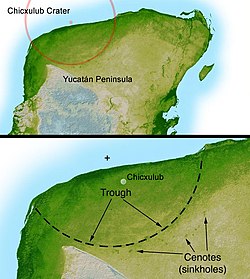
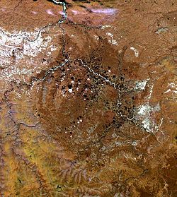
Most recorded impact craters are over 10 million years old, or have widely uncertain ages. The Chicxulub impact has been widely considered the most likely cause for the Cretaceous–Paleogene mass extinction, with some scholars linking other impacts like the Popigai impact in Russia and the Chesapeake Bay impact to later extinction events, though the causal relationship has been questioned.[15]
Some impact events are only known from events like layers of spherules or tektites generated by the impact recorded in contemporary rocks, and their impact structures may no longer exist.
As of 2022[update], the Earth Impact Database (EID) contains 190 confirmed impact structures.[1] The table below is arranged by the continent's percentage of the Earth's land area, and where Asian and Russian structures are grouped together per EID convention.
The global distribution of known impact structures apparently shows a surprising asymmetry,[36] with the small but well-funded European continent having a large percentage of confirmed impact structures. As meteorites impacting Earth should impact evenly across the surface, it is suggested this situation is an artifact, highlighting the importance of intensifying research in less studied areas like Antarctica, South America and elsewhere.[36]
Deniliquin multiple-ring feature– Buried feature in southeast Australia, suggested to be an impact structure (520-kilometre (320mi))-diameter strcture would be the largest one on Earth)
↑ Schultz, Peter H.; Lianza, Ruben E. (1992) "Recent grazing impacts on the Earth recorded in the Rio Cuarto crater field, Argentina", Nature 355, pp. 234–37 (16 January 1992)
↑ Goff, James; Catherine Chagué-Goff; Michael Archer; Dale Dominey-Howes; Chris Turney (3 September 2012). "The Eltanin asteroid impact: possible South Pacific palaeomegatsunami footprint and potential implications for the Pliocene-Pleistocene transition". Journal of Quaternary Science. 27 (7). Wiley: 660. Bibcode:2012JQS....27..660G. doi:10.1002/jqs.2571. ISSN0267-8179. S2CID131415717.
↑ Jones, A.P.; Kearsley, A.T.; Friend, C.R.L.; Robin, E.; Beard, A.; Tamura, A.; Trickett, S.; Claeys, P. (2005). "Are there signs of a large Palaeocene impact, preserved around Disko bay, Greenland- Nuussuaq spherule beds origin by impact instead of volcanic eruption?". Large Meteorite Impacts III. Boulder, Colorado: Geological Society of America. p.281-298. ISBN978-0-81372-384-6.
1 2 Glass, B.P.; Simonson, B.M., eds. (2013). Distal Impact Ejecta Layers: A Record of Large Impacts in Sedimentary Deposits (1sted.). Berlin Heidelberg, Germany: Springer-Verlag. p.716. ISBN978-3-540-88261-9.
1 2 3 Glass, B.P.; Simonson, B.M., eds. (2013). Distal Impact Ejecta Layers: A Record of Large Impacts in Sedimentary Deposits (1sted.). Berlin Heidelberg, Germany: Springer-Verlag. p.716. ISBN978-3-540-88261-9.
This page is based on this Wikipedia article Text is available under the CC BY-SA 4.0 license; additional terms may apply. Images, videos and audio are available under their respective licenses.