
An impact crater is a circular depression in the surface of a solid astronomical body formed by the hypervelocity impact of a smaller object. In contrast to volcanic craters, which result from explosion or internal collapse, impact craters typically have raised rims and floors that are lower in elevation than the surrounding terrain. Impact craters range in size from microscopic craters seen on lunar rocks returned by the Apollo Program to simple bowl-shaped depressions and vast, complex, multi-ringed impact basins. Meteor Crater is a well-known example of a small impact crater on Earth.

Acraman impact structure is a deeply eroded impact crater in the Gawler Ranges of South Australia. Its location is marked by Lake Acraman, a circular ephemeral playa lake about 20 kilometres (12 mi) in diameter. The discovery of the impact structure and independent discovery of its ejecta were first reported in the journal Science in 1986. The evidence for impact includes the presence of shatter cones and shocked quartz in shattered bedrock on islands within Lake Acraman.

Boxhole is a young impact crater located approximately 180 km north-east of Alice Springs in the Northern Territory, Australia. It is 170 metres in diameter and its age is estimated to be 5,400 ± 1,500 years based on the cosmogenic 14C terrestrial age of the meteorite, placing it in the Holocene. The crater is exposed to the surface.
Connolly Basin is a 9 km-diameter impact crater located in the Gibson Desert of central Western Australia. It lies adjacent to the Talawana Track 45 km west of the junction with the Gary Highway, but is difficult to access due to the remoteness of the area. It was originally thought to be a diapir ; an impact origin was first proposed in 1985.,

Gosses Bluff is thought to be the eroded remnant of an impact crater. Known as Tnorala to the Western Arrernte people of the surrounding region, it is located in the southern Northern Territory, near the centre of Australia, about 175 km (109 mi) west of Alice Springs and about 212 km (132 mi) to the northeast of Uluru. It was named by Ernest Giles in 1872 after Australian explorer William Gosse's brother Henry, who was a member of William's expedition.

Goyder is an impact structure, the eroded remnant of a former impact crater. It is situated in Arnhem Land in the Northern Territory, Australia, and was named after the nearby Goyder River. The impact occurred into Mesoproterozoic sedimentary rocks of the McArthur Basin. The deformed area is exposed at the surface and marked by a 3 km diameter ring of fractured and faulted sandstone, which is interpreted as the eroded relic of a central uplift ; the original crater rim, long since removed by erosion, being estimated at approximately 9–12 km diameter. Evidence for an impact origin includes the presence of shatter cones and shocked quartz in outcrops of deformed sandstone at the center of the site.

The Kentland structure, also known as the Kentland crater or the Kentland disturbed area, is an impact structure located near the town of Kentland in Newton County, Indiana, United States.

Lawn Hill ‘crater’ refers to an Ordovician impact structure, the eroded remnant of a former impact crater, situated approximately 220 km north-north-west of Mount Isa in northwestern Queensland, Australia. The site is marked by an 18 km diameter ring of dolomite hills. The origin of this circular feature was uncertain until the discovery of shatter cones and shocked quartz from uplifted rocks at the centre was reported in 1987.

Liverpool is a meteorite impact crater situated in Arnhem Land within the Northern Territory, Australia. It was named after the nearby Liverpool River. Liverpool is remote and difficult to access. The crater has a raised, near-circular rim averaging about 1.6 km in diameter. It was first noticed by geologists during reconnaissance geological mapping in the 1960s, and although an impact origin was considered possible, this was not confirmed until a more detailed study was undertaken in 1970.

Marquez crater is a meteorite crater located in Leon County, Texas near the small town of Marquez about 177 km (110 mi) northeast of Austin, Texas, United States.

Mistastin crater is a meteorite crater in Labrador, Canada which contains the roughly circular Mistastin Lake. The lake is approximately 16 km (9.9 mi) in diameter, while the estimated diameter of the original crater is 28 km (17 mi). The age of the crater is calculated to be 36.6 ± 2 million years (Eocene).

Mount Toondina crater is an impact structure, the eroded remnant of a former impact crater, located in northern South Australia in the locality of Allandale Station about 24 km (15 mi) south of the town of Oodnadatta. Mount Toondina is the high point of a circular topographic feature rising out of an otherwise relatively flat desert area of the Eromanga Basin. An impact origin was first suggested in 1976, challenging the earlier diapir hypothesis, and strongly supported by subsequent studies. A geophysical survey using gravity methods indicates an internal structure typical of complex impact craters, including an uplifted centre, and suggests that the original crater was about 3–4 km in diameter. The crater must be younger than the Early Cretaceous age of the rocks in which it is situated, but otherwise is not well dated. It has clearly undergone significant erosion since the impact event.

Rochechouart impact structure or Rochechouart astrobleme is an impact structure in France. Erosion has over the millions of years mostly destroyed its impact crater, the initial surface expression of the asteroid impact leaving highly deformed bedrock and fragments of the crater's floor as evidence of it.

Shoemaker is an impact structure, the deeply eroded remnant of a former impact crater, situated in arid central Western Australia, about 100 km (62 mi) north-northeast of Wiluna. It is named in honour of planetary geologist Eugene Shoemaker.
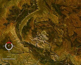
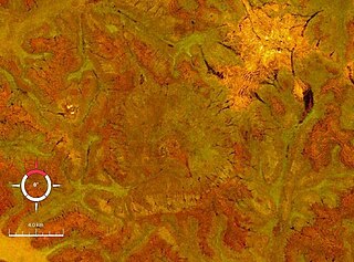
Spider is an impact structure, the deeply eroded remnant of a former impact crater, situated in the Kimberley region of northern Western Australia, 18 km east of the Mount Barnett Roadhouse on the Gibb River Road. Due to very rugged terrain the site is effectively inaccessible. The name is derived from the visually striking spider-like radiating ridges of quartzite prominently visible from the air or on satellite images.

Strangways is a large impact structure, the eroded remnant of a former impact crater, located in the Northern Territory of Australia about 65 kilometres (40 mi) east-south-east of the town of Mataranka. It was named after the nearby Strangways River. The location is remote and difficult to access. Its age has been determined as approximately 646 Ma.

Woodleigh is a large meteorite impact structure (astrobleme) in Western Australia, centred on Woodleigh Station east of Shark Bay, Gascoyne region. A team of four scientists at the Geological Survey of Western Australia and the Australian National University, led by Arthur J. Mory, announced the discovery in the 15 April 2000 issue of Earth and Planetary Science Letters.
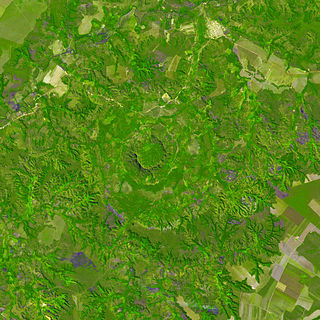
Serra da Cangalha is an impact crater in the State of Tocantins, near the border of Maranhão State, in north/northeastern Brazil. The crater is between 12 and 13 kilometres in diameter, making it the second-largest known crater in Brazil. Its age is estimated to be about 220 million years. The name means Pack-Saddle Mountains in Portuguese.
Amelia Creek crater is an impact structure, the eroded remnant of a former impact crater, located in the Davenport Range, Northern Territory, Australia. It lies within a low range of Paleoproterozoic sedimentary and volcanic rocks, which are extensively folded and faulted, thus making an eroded impact crater difficult to recognize. It was only discovered by the identification of shatter cones near its centre. The central shatter cone locality is surrounded by a 20 by 12 km area of anomalous deformation, the asymmetry being possibly related to very oblique impact, but may be at least partly due to the preexisting structural complexity of the rocks. This deformed zone gives the best estimate for the original size of the crater. Impact took place after folding of the Paleoproterozoic rocks but before deposition of Neoproterozoic and Cambrian rocks which overlie them, thus constraining the impact event to the interval between about 1660 and 600 Ma.

Glikson crater is an impact structure, the eroded remnant of a former impact crater, situated in the Little Sandy Desert of central Western Australia. A possible impact structure was first reported in 1997, and named after Australian geologist A. Y. Glikson, attention to the site being drawn by the presence of a prominent 14 km diameter ring-shaped aeromagnetic anomaly. The area within the ring contains sparse outcrop of uplifted and deformed Neoproterozoic sandstone, but is largely covered by sand dunes. The recent discovery of shatter cones and microscopic shock effects is reliable evidence for an impact origin. Deformation of the sandstone consistent with an impact origin extends out to a diameter of 19 km, which is the best estimate for the original diameter of the original crater. The ring-shaped aeromagnetic anomaly was probably caused by disruption of a horizontal layer of magnetic igneous rock, known as a sill, by the impact event. Nearby outcrops of dolerite have been dated at 508 ± 5 Ma (Middle Cambrian), and if this is the same rock causing the aeromagnetic anomaly, then the impact must be younger, probably of Paleozoic age.


