As of 2022, the total population of the district was 706,135 compared to 638,604 in 2011.[2] The growth rate of population during the decade was 0.96. The population in the district was 29.9 per cent of the total population in the country. Main population centers in Central include Palapye and Serowe, two of Africa's largest traditional villages. The district also contains tributaries of the Limpopo River, which are prone to flash floods when sudden rainstorms drain eastward into the Limpopo. The district is administered by a district administration and district council which are responsible for local administration. The total number of workers constituted 186,943 with 95,717 males and 91,221 females, with a majority working in transport and communication sector.
Most part of Botswana has tableland slopes sliding from east to west. The region has an average elevation of around 915m (3,002ft) above the mean sea level. The vegetation type is Savannah, with tall grasses, bushes and trees. The annual precipitation is around 65cm (26in), most of which is received during the summer season from November to May. Most of the rivers in the region are seasonal, with Limpopo River, which are prone to flash floods, being the most prominent.[4] There are conflicts between agricultural expansion and protection of indigenous wildlife within the Central District. There are several seasonal rivers in the district including the Boteti River and the Lepashe River, whose flows in the rainy season reach the Makgadikgadi Pans.[5]
As of 2011, the total population of the district was 576,064 compared to 501,381 in 2001. The growth rate of population during the decade was 1.40. The population in the district was 28.45 per cent of the total population in the country. The sex ratio stood at 94.01 for every 100 males, compared to 91.82 in 2001. The average house hold size was 3.37 in 2011 compared to 4.51 in 2001. There were 18,838 craft and related workers; 5,678 clerks; 35,256 people working in elementary occupation; 2,359 legislators, administrators and managers; 5,921 plant and machine operators and assemblers; 3,022 professionals; 12,864 service workers, shop and market sales workers; 9,019 skilled agricultural and related workers; and 7,325 technicians and associated professionals, making the total work force of 101,149.[6]
Education and economy
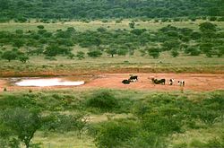
Aerial view of Boteti river
As of 2011, there were a total of 264 schools in the district, with 23.30 per cent private schools. The total number of students in the Council schools was 113,632, while it was 3,848 in private schools. The total number of students enrolled in the district was 117,480: 57,378 girls and 60,102 boys. The total number of qualified teachers was 4,585, 3,441 female and 1,144 male. There were around 132 temporary teachers, 69 male and 201 female. There were no untrained teachers in the district.[7]
As of 2006, 80,594 were involved in agriculture, 8,423 in construction, 14,237 in education, 1,165 in electricity and water, 1,034 in finance, 49 in foreign mission, 4,396 in health, 4,218 in hotels and restaurants, 10,664 in manufacturing, 4,900 in mining and quarrying, 2,894 in other community services, 8,385 in private households, 16,022 in public administration, 4,489 in real estate, 3,927 in transport and communications, and 21,546 in wholesale and retail trade. The total number of workers was 186,943, 95,717 male and 91,221 female.[8]
Administration
Botswana gained independence from the British in 1966 and adapted the colonial administration framework to form its district administration. The policies were modified during 1970–74 to address some of the basic issues.[9] The district is administered by a district administration and district council which are responsible for local administration. The policies for the administration are framed by the Ministry of Local Government. The major activities of the council are Tribal Administration, Remote Area Development and Local Governance. The executive powers of the council are vested on a commissioner appointed by the central government. Technical services wing of the Department of Local Government is responsible for developing roads, infrastructure in villages like water supply, schools and recreational facilities.[10] All the staff of the local administration expect District Administration are selected via Unified Local Government Services (ULGS) and the Ministry of Local Government is responsible for their training, deployment and career development.[11] The six sub-districts of Central District created as a part of National Development Park of the district are Bobonong, Boteti, Mahalapye, Orapa, Serowe Palapye and Tutume.[12]
↑ Petter, Jan; Hansen, Huberth; Lillethun, Arvid. Resource utilization in the Central District CFDA, Botswana: with special reference to arable farming systems and conflicts in resource management - livestock versus wildlife.
↑ Picard, Louis A. (1979). "Rural Development in Botswana: Administrative Structures and Public Policy". The Journal of Developing Areas. 13 (3). Louis A. Picard: 283–300. JSTOR4190662.
This page is based on this Wikipedia article Text is available under the CC BY-SA 4.0 license; additional terms may apply. Images, videos and audio are available under their respective licenses.