Botswana, officially the Republic of Botswana, is a landlocked country in Southern Africa. Botswana is topographically flat, with up to 70 percent of its territory being the Kalahari Desert. It is bordered by South Africa to the south and southeast, Namibia to the west and north, and Zimbabwe to the northeast. It is connected to Zambia across the short Zambezi River border by the Kazungula Bridge.
The Batswana, a term also used to denote all citizens of Botswana, refers to the country's major ethnic group. Prior to European contact, the Batswana lived as herders and farmers under tribal rule.

Gaborone is the capital and largest city of Botswana with a population of 246,325 based on the 2022 census, about 10% of the total population of Botswana. Its agglomeration is home to 421,907 inhabitants at the 2011 census.
Mochudi is one of the larger villages in Botswana with a population of 44,815 people in 2011. It is situated in the Bakgatla tribal region, in Kgatleng District, about 37 km (23 mi) northeast of Gaborone. The village lies several kilometres from the main Gaborone–Francistown road, and can be accessed through a short turn at Pilane. Mochudi was settled by the Tswana people in 1871. The main attraction in Mochudi is the Phuthadikobo Museum which is perched at the top of a hill and holds a rich history of Bakgatla tribe and Batswana in general.
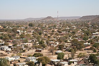
Francistown is the second largest city in Botswana, with a population of about 103,417 and 147,122 inhabitants for its agglomeration at the 2022 census. and often described as the "Capital of the North" or as the natives would have it “Turopo ya muka” which is in the iKalanga language. It is located in eastern Botswana, about 400 kilometres (250 mi) north-northeast from the capital, Gaborone. Francistown is located at the confluence of the Tati and Ntshe rivers, and near the Shashe River and 90 kilometres from the international border with Zimbabwe. Francistown was the centre of Southern Africa's first gold rush and is still surrounded by old and abandoned mines. The City of Francistown is an administrative district, separated from North-East District. It is administered by Francistown City Council.The main language spoken and used in and around Francistown is the Kalanga language. Other languages used in the area are isiNdebele, ChiShona as well as SeTswana.

The Kingdom of Mapungubwe was a medieval state in South Africa located at the confluence of the Shashe and Limpopo rivers, south of Great Zimbabwe. The name is derived from either TjiKalanga and Tshivenda. The name might mean "Hill of Jackals" or "stone monuments". The kingdom was the first stage in a development that would culminate in the creation of the Kingdom of Zimbabwe in the 13th century, and with gold trading links to Rhapta and Kilwa Kisiwani on the African east coast. The Kingdom of Mapungubwe lasted about 80 years, and at its height the capital's population was about 5000 people.

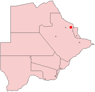
The North-East District is one of the administrative districts of Botswana. Its capital is Francistown. In 2011, North-East had a population of 60,264 people. The district is predominantly occupied by Kalanga-speaking people, the BaKalanga. The district is administered by a district administration and district council, which are responsible for local administration.

Kweneng is one of the districts of Botswana and is the recent historical homeland of the Bakwena people, the first group in Botswana converted to Christianity by famed missionary David Livingstone. Various landmarks, including Livingstone's Cave, allude to this history. The seat of the district's government is Molepolole, Botswana's most populous village.

The North-West District or Ngamiland is one of the first-level administrative subdivisions of Botswana. For census and administrative purposes Ngamiland is subdivided into Ngamiland East, Ngamiland West and Ngamiland Delta (Okavango). It is governed by a District Commissioner, appointed by the national government, and the elected North-West District Council. The administrative centre is Maun.

Central is the largest of Botswana's districts in terms of area and population. It encompasses the traditional homeland of the Bamangwato people. Some of the most politically connected Batswana have come from the Central District, including former President Sir Seretse Khama, former President Festus Mogae, and former President Lt. General Seretse Ian Khama. The district borders the Botswanan districts of Chobe in the north, North-West in the northwest, Ghanzi in the west, Kweneng in southwest, Kgatleng in the south and North-East in the northeast, as well as Zimbabwe also in the northeast and South Africa in the southeast.
Masunga /ˈmɑːsuŋɡʌ/ is a Bakalanga settlement in the North-East District of Botswana. The village is the Headquarters of the North East District. The nearest city is Francistown which is about 120 km (75 mi) away. The Chief of the region is Kgosi Thabo Maruje Masunga III, who took over from his uncle Christopher Masunga.

Tonota is a village located in the Central District of Botswana.
Tutume is a large Bakalanga village located in the Central District of Botswana, about 50 km from the Zimbabwe border gate at Maitengwe. The nearest city is Francistown, about 100 km away. The village is a sub district headquarters and has a population of 23,000 .It is made up of wards: Sitabule(Madikwe),Tjilagwani(Selolwane), Thini and Madandume (Magapatona). In each ward there is a headman and his advisers in the kgotla. The main kgotla is located in Madikwe ward near Tutume Central Primary School. The village was named after the river "TUTUME", in Kalanga they will say "gwizi go Tutuma", meaning that the river was overflowing.
Plumtree is a town in Zimbabwe. Alongside marula trees, wild plum trees grow abundantly in area. The town was once called Getjenge by baKalanga. Another name which is mainly used is Titji, meaning station and referring to the railway station which was operating in the area around 1897.
Many languages are spoken, or historically have been spoken, in Zimbabwe. Since the adoption of its 2013 Constitution, Zimbabwe has 16 official languages, namely Chewa, Chibarwe, English, Kalanga, Koisan, Nambya, Ndau, Ndebele, Shangani, Shona, sign language, Sotho, Tonga, Tswana, Venda, Xhosa. The country's main languages are Shona, spoken by over 70% of the population, and Ndebele, spoken by roughly 20%. English is the country's lingua franca, used in government and business and as the main medium of instruction in schools. English is the first language of most white Zimbabweans, and is the second language of a majority of black Zimbabweans. Historically, a minority of white Zimbabweans spoke Afrikaans, Greek, Italian, Polish, and Portuguese, among other languages, while Gujarati and Hindi could be found amongst the country's Indian population. Deaf Zimbabweans commonly use one of several varieties of Zimbabwean Sign Language, with some using American Sign Language. Zimbabwean language data is based on estimates, as Zimbabwe has never conducted a census that enumerated people by language.
The Kalanga or Bakalanga are a southern Bantu ethnic group mainly inhabiting Matebeleland in Zimbabwe, northeastern Botswana and Limpopo Province in South Africa. They are historically related to the Nambya, Karanga,bapedi and Venda.
BaTalaote are an ethnic group found in the central district of Botswana and south-western parts of Zimbabwe. They are part of a large group of ethnic groups called Bakalanga. Over the years Batalaote lost their language and adopted Kalanga for those in Zimbabwe and Sengwato, which is spoken by the Bangwato, for those in Botswana. The Talaunda and the Wadoma could share a common ancestor. Both tribes have significantly high cases of ectrodactyly.
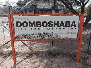
Domboshaba ruins is a cultural and heritage site in Botswana originally occupied towards the end of the Great Zimbabwe period. The site is a respected place for the people living in the region and it is believed that the chief lived on the top of the hill together with his helpers or assistants.

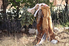
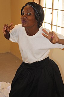
Dihosana is a traditional dance by Kalanga people or Ikalanga people which existed for a long period of time. Dihosana involves the invitation of ancestors through trance to pray for rain. It is a rain making dance. Dihosana is a dance heritage which has been inherited from the fore fathers by those practising it. People living in the north, approximately about 20 to 30 km north of Francistown, Botswana are believed to be the veteran elders of the Dihosana dance, in a village called Makobo. Hosana is a Kalanga term an old and wise person. The dancers usually dance in groups and wear black skirts, and long strings of beads in their necks. The beads are grouped in many different colour categories from red, black and white, a myriad in the body and waist. Hosana is part of the Kalanga culture and not everyone qualifies to be a Hosana dancer.
Zwenshambe is a village in the North-East District of Botswana. It is situated between Gungwe village in the west, Nlapkhwane village in the east, Mulambakwena village in the south and the Zimbabwe border in the north. It is not far from the Ramokgwebana Border Post. The nearest city to Zwenshambe is Francistown which is also the second largest city in Botswana.