Palapye

Last updated • 7 min readFrom Wikipedia, The Free Encyclopedia
Palapye
Palapye1987.jpg
Palapye in 1987
Nickname: 
PY/Sphalabanyana/ Playtown
Botswana location map.svg
Red pog.svg
Palapye
Location of Palapye in Botswana
Coordinates: 22°33′S27°08′E / 22.550°S 27.133°E / -22.550; 27.133
Country Flag of Botswana.svg Botswana
District Central District
Sub-District Serowe/Palapye
Government
  Member of Parliament (MP) Onneetse Ramogapi

Preceded by member of Parliament (MP)

Moiseraele Master Goya
  Chief Martha Lebang preceded by Chief Keetla Masogo
Elevation
919 m (3,015 ft)
Population
 (2021) [1]
  Total
80,000
Time zone UTC+2 (Central Africa Time)
  Summer (DST) UTC+2 (not observed)
Area code 49xxxxx
Climate BSh
Website http://www.palapye.com/

Palapye is a growing town in Botswana, situated about halfway between Francistown and Gaborone (170 km (106 mi) from Francistown and 240 km (149 mi) from Gaborone). Over the years its position has made it a convenient stopover on one of Southern Africa's principal north–south rail and road routes. [2]

Contents

Located here is the Morupule Colliery, which supplies Morupule Power Station, Botswana's principal domestic source of electricity. The power station has undertaken an expansion project to increase its generation capacity in an effort to meet the country's increasing demand for electricity. Construction began in 2010. As of May 2021, Morupule A plant produces 132 MW of electricity, while Morupule B produces 600 MW. [3]

In 1997 Palapye was said to be the fastest-growing village in Africa, and was expected to expand its population from 30,000 to 180,000.

History

The Bamangwato people, under Kgosi Khama III, are widely believed to be the first people to have settled near present-day Palapye. Their capital was the settlement of Phalatswe, also called Old Palapye, and was situated at the western end of the Tswapong Hills. Palapye was originally spelled as Phalatswe, which meant the place for impalas. [4]

It existed up to 1902, and the ruins of its church, built in 1892, are still to be seen a few kilometres from Palapye's town centre. Chief Khama contributed some 3,000 pounds to its construction and took a keen interest in church affairs. The Bamangwato people's houses were initially clustered around the church, but finding its vicinity too rocky, they moved 1.5 km (0.93 mi) from Gaborone and away. [5]

The name Palapye, formerly rendered as Palachwe or Palapye, refers to the Impala antilope. [6]

Geography

Palapye is situated nearly 70 km (43 mi) north of the Tropic of Capricorn, by the Lotsane River, towards the central-eastern edge of Botswana. [7]

KgotlaPopulation
Serorome10000
Boikago5000
Madiba6000
Lotsane8000
Thomaditshotse11000
Khurumela13000
Boseja3000
Morupule2000
Mmaphula15000
Rebaeng2500
Kgaswe900
Extension 1
Extension 2
Extension 3
Extension 4
Extension 5
Extension 6
Extension 7
Extension 8
Extension 9
Extension 10
Extension 11

Climate

Summer months are from mid-September to mid-April. Summers are very hot in Palapye, with daytime temperatures reaching up to 40 °C. Thunderstorms are plentiful in the summer. Rainfall levels reach usually a minimum of 300 mm annually. Winters in Palapye are mild and dry. [8]

Demographics

Palapye's population is believed to be bordering the 80,000 mark, however, this is not an official figure, with many quarters arguing that the actual number is much higher or lower. According to 2022 2022 Population and Housing Census preliminary results, Palapye has registered 3.3% population growth rate from 2011 it was 37,256 and in 2022 is 52,398, [9] Christianity is the main religious belief amongst Palapye citizens. However, there is considerable population of Muslim and Hindu believers in the town. [10]

Infrastructure and developments

The Palapye Water Affairs currently provides the town with an abundant supply of water. The works is located a few kilometres outside the town. The Affairs provides Serowe with water, through a new pipe network since 2008.[ citation needed ] Due to current blackouts across the country, resulting from South Africa's refusal to supply electricity to Botswana, construction has been halted for many projects. However, they have resumed, the most important project being the expansion of the Morupule Power Station. [11] The Morupule Expansion Project 1, with an estimated budget of P1.5 billion, is expected to produce 3.8 million tonnes of coal.

Plans for a new hospital, similar to the newly constructed Serowe Hospital, have also been proposed. A new police station has been completed in 2012. It is located along the A1 Highway in the old industrial area.

From being a mere stop-over, Palapye is rapidly developing to one of Botswana's main financial, residential, industrial and educational hubs. New malls and educational institutions continue to mushroom gradually in Palapye. The town's physical size has more than doubled since the 1990s.[ citation needed ]

Palapye also has a professional recording studio, called Ruff Riddims, built in early 2009. It is the first of its kind in Palapye. [12]

Sport

The main sport played in Palapye is football, with many people also playing softball and volleyball. Sports are usually played at school grounds, which have adequate facilities and fields. Palapye has currently six known soccer teams, Palapye All Stars, Morupule Wanderers, FC Palapye, Palapye United and Palapye Swallows and Motlakase Power Dynamos. However, due to there being no stadium in the town, the three teams which usually played at Premier and First Division league usually play their matches elsewhere, although occasionally some games are played Palapye Swallows and PU Grounds. While in those leagues they play their matches in Orapa, Francistown, Sua, Maun or Selibe Phikwe. [13] Both teams are not well known teams, gathering only a very small handful of supporters.

Education

Lotsane Senior Secondary School is one of the main government schools in Palapye. It accommodates learners from Forms 4 to 5. It is one of the very few boarding schools in the area and publishes a school newsletter called Lotsane.Other government schools in Palapye include Mabogo JSS, Palapye JSS and Mmaphula JSS. Popular private institutions in the town are; Kgaswe High School and Royal Professional College (which also offers tertiary level programmes). Also, there is a vocational institution that existed for over fifteen years in the town; Palapye Technical College (PATECO), formerly Palapye Vocational Technical College (VTC).[ citation needed ]

University

Since the year 2000, rumours circulated of a university to be built in Palapye. After numerous delays and extensive research, a project was finally accepted in 2004. BIUST ( Botswana International University of Science and Technology ) began construction of its campus in December 2009. [14] The construction of the first phase of the university was expected to cost, close to P450 million. It was completed in late 2012, with the first students enrolled in August 2012. These first students, initial attended school in Oodi at Oodi College of Applied Arts and Technology whilst awaiting completion of the BIUST campus.[ needs update ] The university was intended to help ease the burden on the University of Botswana, in the country's capital, Gaborone. The University of Botswana was struggling to meet the demand for an increased number of students. The BIUST Campus is situated on a 2,500 hectares (9.7 sq mi) site on the Tswapong Hills, south east of Palapye [15] near the site of Palapye Water Affairs.

There is also a proposed plan by the University of Botswana to expand its Faculty of Medicine and locate it in Palapye.

Transport

Road

Palapye lies on the main A1 Highway, which connects Botswana's two major cities, Gaborone and Francistown. There is a secondary road that leads to Serowe, and later, Orapa and Lethlakane.

Rail

The national railway, which connects all major towns and cities all over Botswana to each other, also passes through Palapye. The rail track through Palapye links the town to Gaborone and Francistown. Coal that is mined from other regions in Botswana, such as Selebi-Phikwe, is sent by rail to Palapye. A proposed rail link to Bulawayo, Zimbabwe has been touted to operate, but such plans are still to be considered by the government.

In 2008, proposals were made to build a new Trans-Kalahari Railway to a port in Namibia, but this is expected to begin construction in 2025. [16]

Air

Palapye Airport is a small airfield located just outside the town.

An International Airport, that will be located on the Palapye-Serowe road, is another development that is being considered. If plans do go ahead for the proposed Palapye International Airport, it will be the country's fifth international airport, after Sir Seretse Khama International Airport in Gaborone, Francistown Airport, Maun Airport and Kasane Airport, easing the increased traffic that is currently being experienced at the present airports. However, such plans have been put on halt due to the current renovations and expansion at Gaborone Airport and a newly renovated Francistown Airport.

Tourist attractions

There are several well-known tourist attractions close to Palapye. Khama Rhino Sanctuary, 15 km (9 mi) outside of neighbouring Serowe, is probably the best known and is some 50 km (31 mi) from Palapye. Here, there are endangered black and white rhino.

The Tswapong Hills also have many areas of historical significance and well as the Moremi Gorge. This is an area of great beauty as it has a permanent water source.

About 20 km (12 mi) ESE of Palapye, close to the village of Malaka, are the remains of Phalatswe, also called Old Palapye, the capital of the Bamangwato people under Khama III from 1889 to 1902. [17]

Related Research Articles

<span class="mw-page-title-main">Transport in Botswana</span>

Transportation in Botswana is provided by an extensive network of railways, highways, ferry services and air routes that criss-cross the country. The transport sector in Botswana played an important role in economic growth following its independence in 1966. The country discovered natural resources which allowed it to finance the development of infrastructure, and policy ensured that the transport sector grew at an affordable pace commensurate with demands for services.

<span class="mw-page-title-main">Gaborone</span> Capital and the largest city of Botswana

Gaborone is the capital and largest city of Botswana with a population of 246,325 based on the 2022 census, about 10% of the total population of Botswana. Its agglomeration is home to 534,842 inhabitants at the 2022 census.

Serowe is an urban village in Botswana's Central District. A trade and commercial centre, it is Botswana's third largest village. Serowe has played an important role in Botswana's history, as capital for the Bamangwato people in the early 20th century and as birthplace of several of Botswana's presidents. More recently it has undergone significant development as the town and as Botswana continues to grow.

Air Botswana Corporation is Botswana's state-owned national flag carrier, with its headquarters located in Gaborone. It operates scheduled domestic and regional flights from its main base at Sir Seretse Khama International Airport. Air Botswana has been loss-making for several years, and there have been various attempts to privatise the company, and frequent changes to the corporation's management and board, so far without reducing the losses.

<span class="mw-page-title-main">Francistown</span> City in North-East District, Botswana

Francistown is the second-largest city in Botswana, with a population of about 103,417 and 147,122 inhabitants for its agglomeration at the 2022 census. It is located in eastern Botswana, about 400 kilometres (250 mi) north-northeast from the capital, Gaborone. Francistown is located at the confluence of the Tati and Ntshe rivers, and near the Shashe River and 90 kilometres (56 mi) from the international border with Zimbabwe.

<span class="mw-page-title-main">Central District (Botswana)</span> District in Botswana

Central is the largest of Botswana's districts in terms of area and population. It encompasses the traditional homeland of the Bamangwato people. Some of the most politically connected Batswana have come from the Central District, including former President Sir Seretse Khama, former President Festus Mogae, and former President Lt. General Seretse Ian Khama. The district borders the Botswanan districts of Chobe in the north, North-West in the northwest, Ghanzi in the west, Kweneng in southwest, Kgatleng in the south and North-East in the northeast, as well as Zimbabwe also in the northeast and South Africa in the southeast.

Bobonong is a town in the Central District of Botswana 80 km from Selibe Phikwe town. Bobonong has a population of around 19,000. The Babirwa tribe can be found in this town. The Botswana Pink semi-precious stones can be found in Bobonong region. The Babirwa are known for harvesting the mophane worm. The locals refer to the town as Bobcity or formerly Lekgarapeng, which was derived from the stoney landscape of the town.

The Bamangwato is one of the eight "principal" Tswana chieftaincies of Botswana. They ruled over a majority Bakalanga population, with minorities including the Basarwa, Birwa and Tswapong. The modern Bamangwato formed in the Central District, with its main town and capital at Serowe. The paramount chief, a hereditary position, occupies one of the fifteen places in Ntlo ya Dikgosi, the national House of Chiefs.

<span class="mw-page-title-main">Morupule Thermal Power Station</span> Coal-powered power station in Botswana

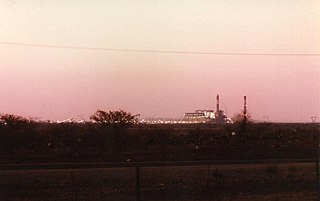
Morupule Thermal Power Station is a coal-fired power station in Botswana. It is responsible for an estimated 80 percent of the country's domestic power generation.

Shoshong is a town in Botswana, formerly the chief settlement of the eastern Bamangwato.

<span class="mw-page-title-main">Botswana Railways</span> National railway operator of Botswana

Botswana Railways (BR) is the national railway of Botswana.

<span class="mw-page-title-main">Rail transport in Botswana</span> Rail transportation in Botswana including its history and current network.

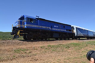
Rail services in Botswana are provided by Botswana Railways. Most routes in the country radiate from Gaborone. The railway network consists of 888 km of track; its gauge is 1,067 mm cape gauge.

Serule is a village in Central District of Botswana. Serule, with a latitude of -21.95 and a longitude of 27.3, is a streets, highways, roads, or railroad. The village is located along the road between Francistown and Palapye, and is an important railroad junction with rails leading towards north to Francistown, south to Palapye and east to the mining town of Selebi-Phikwe, 72 km from Palapye north up the A1 road, 88 km from Francistown down south the A1 road and 60 km west of Selibe Phikwe to the T-junction. The location is situated 340 kilometres east (90°) of the approximate centre of Botswana and 332 kilometres north east (26°) of the capital Gaborone.

List of Railway stations in Botswana include:

Yarona FM is an urban broadcaster targeting young adults. The radio station is a private commercial entity that has existed since 1999. It is regulated by BOCRA and attracts a unique weekly audience of 250,000.

<span class="mw-page-title-main">Lotsane River</span> River in Botswana

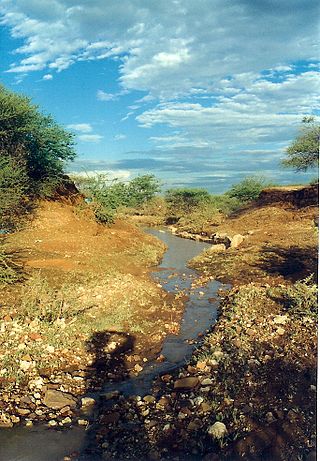
The Lotsane River is a river in southeastern Botswana. It is a seasonal left hand tributary of the Limpopo River and has a catchment area of 9,748 square kilometres (3,764 sq mi).

<span class="mw-page-title-main">Ministry of Education and Skills Development</span> Government ministry of Botswana

The Ministry of Education and Skills Development is a government ministry of Botswana. Its offices are in Gaborone. The Ministry of Tertiary Education, Research Science and Technology exists to provide and build knowledge and innovation through the development and implementation of policy on Tertiary Education, Research, Science and Technology to transform Botswana in to a knowledge based society through effective stakeholder collaboration

The Selebi-Phikwe Solar Power Station, is a 50 MW (67,000 hp) solar power plant under development in Botswana. It is owned and is being developed by Scatec, the multinational energy conglomerate, whose headquarters are located in Oslo, Norway. The off-taker is Botswana Power Corporation (BPC), under a 25-year power purchase agreement (PPA).

References

  1. "2011 Census". Archived from the original on January 11, 2013.
  2. "Palapye Travel Information". www.botswana-info.com. Retrieved 2020-05-26.
  3. Writer, By Brian Benza
    Staff (2010-02-22). "Construction Of 600 Mw Morupule B Power Station Begins". Mmegi Online. Retrieved 2022-05-30.
  4. "Palapye Travel Information". www.botswana-info.com. Retrieved 2020-05-26.
  5. Campbell, Alec (2008). "Khama III, Missionaries and Old Palapye Church Building". Botswana Notes and Records. 40. Botswana Society: 172–175. JSTOR   41236043.
  6. Raper, P. E. Palapye . Retrieved 28 October 2013.{{cite book}}: |work= ignored (help)
  7. "Palapye Travel Information". www.botswana-info.com. Retrieved 2020-05-26.
  8. "1996 Climate Map for Palapye".
  9. "2022 Population and Housing Census Preliminary Results". Statistics Botswana. 2022-05-10. Retrieved 2022-05-30.
  10. Statistics Botswana. "Serowe/Palapye Sub District, Population and Housing Census 2011Selected Indicators" (PDF).
  11. "Moruple Colliery". Archived from the original on 2008-02-21. Retrieved 2008-02-23.
  12. "Palapye's first recording studio". Mmegi. 26 April 2007. Retrieved July 29, 2009.
  13. "FC Palapye".
  14. "BIUST construction commencement". Mmegi. 27 April 2007. Retrieved December 11, 2009.
  15. "The BIUST Campus". Archived from the original on 2015-06-15.
  16. "Crumbling South African Rail Prompts Botswana to Forge New Route". Bloomberg.com. 2023-12-19. Retrieved 2024-11-20.
  17. "History of Phalatswe".

22°33′S27°08′E / 22.550°S 27.133°E / -22.550; 27.133