
Transportation in Botswana is provided by an extensive network of railways, highways, ferry services and air routes that criss-cross the country. The transport sector in Botswana played an important role in economic growth following its independence in 1966. The country discovered natural resources which allowed it to finance the development of infrastructure, and policy ensured that the transport sector grew at an affordable pace commensurate with demands for services.

Gaborone is the capital and largest city of Botswana with a population of 246,325 based on the 2022 census, about 10% of the total population of Botswana. Its agglomeration is home to 534,842 inhabitants at the 2022 census.
Serowe is an urban village in Botswana's Central District. A trade and commercial centre, it is Botswana's third largest village. Serowe has played an important role in Botswana's history, as capital for the Bamangwato people in the early 20th century and as birthplace of several of Botswana's presidents. More recently it has undergone significant development as the town and as Botswana continues to grow.

Palapye is a growing town in Botswana, situated about halfway between Francistown and Gaborone. Over the years its position has made it a convenient stopover on one of Southern Africa's principal north–south rail and road routes.

Central is the largest of Botswana's districts in terms of area and population. It encompasses the traditional homeland of the Bamangwato people. Some of the most politically connected Batswana have come from the Central District, including former President Sir Seretse Khama, former President Festus Mogae, and former President Lt. General Seretse Ian Khama. The district borders the Botswanan districts of Chobe in the north, North-West in the northwest, Ghanzi in the west, Kweneng in southwest, Kgatleng in the south and North-East in the northeast, as well as Zimbabwe also in the northeast and South Africa in the southeast.
The Bamangwato is one of the eight "principal" Tswana chieftaincies of Botswana. They ruled over a majority Bakalanga population, with minorities including the Basarwa, Birwa and Tswapong. The modern Bamangwato formed in the Central District, with its main town and capital at Serowe. The paramount chief, a hereditary position, occupies one of the fifteen places in Ntlo ya Dikgosi, the national House of Chiefs.
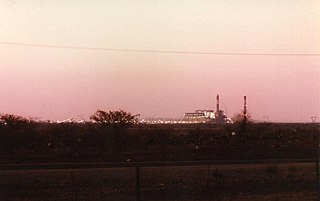
Morupule Thermal Power Station is a coal-fired power station in Botswana. It is responsible for an estimated 80 percent of the country's domestic power generation.

Botswana Railways (BR) is the national railway of Botswana.

The districts of Botswana are subdivided into sub-districts. The sub-districts are listed below, by district:

The Kazungula Ferry was a pontoon ferry across the 400-metre-wide (1,300 ft) Zambezi River between Botswana and Zambia. It was one of the largest ferries in south-central Africa, having a capacity of 70 tonnes. The service was provided by two motorised pontoons and operated between border posts at Kazungula, Zambia and Kazungula, Botswana.
List of Railway stations in Botswana include:

The Tuli Block is a narrow fringe of land at Botswana's eastern border wedged between Zimbabwe in the north and east and South Africa in the south. It consists mainly of privately owned game farms offering safari tourism. The eastern section up to and including Redshield has been declared a game reserve, known as the Northern Tuli Game Reserve.
Botswana Power Corporation (BPC) is a state-owned company for electrical power generation, transmission and distribution in Botswana. It was established in 1970 and is currently the only electricity supplier in the country. BPC represents Botswana in the Southern African Power Pool. Morupule Power Station (coal-fired) in Palapye supplies 80% of domestically generated electricity, however the country is dependent on importing energy from its neighbours. Its capacity is estimated to be around 132 MW. The region's main power supplier, South Africa, is experiencing its own problems with under-capacity blackouts. A plan to boost Morupule station with four new 150 MW units is underway and gathering financial support from several sources.

The Botswana International University of Science & Technology, or BIUST, is an international university located in the town of Palapye, Botswana. It is the nation's second university, after the University of Botswana in the country's capital, Gaborone. The location is a 2,500-hectare (9.7 sq mi) site of gently sloping land on the outskirts of Palapye.
Motlakase Power Dynamos are a football club based in Palapye, Botswana, playing in the second division Botswana First Division North.
Old Palapye is a heritage site located in Botswana, near a town called Palapye. Old Palapye and Palapye are two different places according to the residents there, Palapye is a modernised town. The site is located 20 km away from the Palapye town and the people living around call it Malaka village This monument site is called Old Palapye because it carries the history of the ancient nature which differentiates it from the Palapye town.
The Palapye Solar Power Station, also Lotsane Solar Power Station, is a 100 MW (130,000 hp) solar power station, under development in Botswana. The solar farm is owned and is being developed by Solarcentury from the United Kingdom and ENRC from Botswana. The power generated here is intended to be fed into the Southern Africa Power Pool for export. As of February 2024 the development has received a power generation license from the Botswana Energy Regulatory Authority (BERA).
