The Batswana, a term also used to denote all citizens of Botswana, refers to the country's major ethnic group. Prior to European contact, the Batswana lived as herders and farmers under tribal rule.

Mafikeng, officially known as Mahikeng and previously Mafeking, is the capital city of the North West province of South Africa.

Khama III (1837?–1923), referred to by missionaries as Khama the Good also called Khama the Great, was the Kgosi of the Bangwato people.
Sir Seretse Goitsebeng Maphiri Khama, GCB, KBE was a Motswana politician who served as the first President of Botswana, a post he held from 1966 to his death in 1980.

The Bechuanaland Protectorate was a protectorate established on 31 March 1885, by the United Kingdom of Great Britain and Ireland in Southern Africa. It became the Republic of Botswana on 30 September 1966.
Serowe is an urban village in Botswana's Central District. A trade and commercial centre, it is Botswana's third largest village. Serowe has played an important role in Botswana's history, as capital for the Bamangwato people in the early 20th century and as birthplace of several of Botswana's presidents. More recently it has undergone significant development as the town and as Botswana continues to grow.
Palapye is a growing town in Botswana, situated about halfway between Francistown and Gaborone. Over the years its position has made it a convenient stopover on one of Southern Africa's principal north–south rail and road routes.

Central is the largest of Botswana's districts in terms of area and population. It encompasses the traditional homeland of the Bamangwato people. Some of the most politically connected Batswana have come from the Central District, including former President Sir Seretse Khama, former President Festus Mogae, and former President Lt. General Seretse Ian Khama. The district borders the Botswanan districts of Chobe in the north, North-West in the northwest, Ghanzi in the west, Kweneng in southwest, Kgatleng in the south and North-East in the northeast, as well as Zimbabwe also in the northeast and South Africa in the southeast.
The Bamangwato is one of the eight "principal" Tswana chieftaincies of Botswana. They ruled over a majority Bakalanga population, with minorities including the Basarwa, Birwa and Tswapong. The modern Bamangwato formed in the Central District, with its main town and capital at Serowe. The paramount chief, a hereditary position, occupies one of the fifteen places in Ntlo ya Dikgosi, the national House of Chiefs.

The districts of Botswana are subdivided into sub-districts. The sub-districts are listed below, by district:
Serule is a village in Central District of Botswana. Serule, with a latitude of -21.95 and a longitude of 27.3, is a streets, highways, roads, or railroad. The village is located along the road between Francistown and Palapye, and is an important railroad junction with rails leading towards north to Francistown, south to Palapye and east to the mining town of Selebi-Phikwe, 72 km from Palapye north up the A1 road, 88 km from Francistown down south the A1 road and 60 km west of Selibe Phikwe to the T-junction. The location is situated 340 kilometers east (90°) of the approximate center of Botswana and 332 kilometers north east (26°) of the capital Gaborone.
The Ba-ka-Nswazwi people are originally Bapedi of Mujaji. The Bapedi of Mujaji are Kalangas originally from Munomutapa and were ruled by Mugudo. They are found in Tutume, Nswazwi, Marapong, Masunga and Nkange in Botswana.

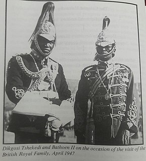
Tshekedi Khama was the regent-king of the Bamangwato tribe in 1926 after the death of Sekgoma II.
The history of Gaborone began with archaeological evidence in the area around Gaborone dating back to 400 BCE, and the first written accounts of Gaborone are from the earliest European settlers in the 19th century. Since the 1960s, when Botswana gained its independence from Britain and Gaborone became the capital, the city has grown from a small village in the Botswana scrubland to a major center in southern Africa.
The Independence Day of Botswana, commonly called Boipuso, is a national holiday observed in Botswana on September 30 of every year. The date celebrates Botswana's Declaration of Independence from the United Kingdom on September 30, 1966.
Mma-Besi or Mabisa was a mohumagadi of the BaNgwato of the Bechuanaland Protectorate, now Botswana, and the first wife of king Khama III. She was also known as Elisabeta Gobitsamang Khama.
Old Palapye is a heritage site located in Botswana, near a town called Palapye. Old Palapye and Palapye are two different places according to the residents there, Palapye is a modernised town. The site is located 20 km away from the Palapye town and the people living around call it Malaka village This monument site is called Old Palapye because it carries the history of the ancient nature which differentiates it from the Palapye town.
Sekgoma Memorial Hospital is a government-run district hospital located in Serowe, a town in Botswana's Central District. A trade and commercial centre, it is Botswana's largest village rich with the history of Botswana.

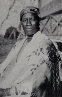
Semane Setlhoko Khama (1881–1937) was a mohumagadi of the BaNgwato chieftaincy in the Bechuanaland Protectorate. Educated in a missionary school, she became a teacher and upon her marriage to Khama III continued to press for education for the BaNgwato. A proponent of modern medicine, she was influential in bringing modern midwifery to the area. As a devout Christian, she encouraged women's involvement in the church and the Woman's Christian Temperance Union.


