Molepolole

Last updated
Molepolole
village
New Molepolole Shopping Mall.jpg
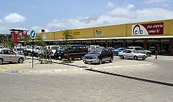
Mafenyatlala Shopping Mall
Nickname(s): 
phuase, phua lerole
Botswana location map.svg
Red pog.svg
Molepolole
Coordinates: 24°24′24″S25°29′42″E / 24.40667°S 25.49500°E / -24.40667; 25.49500 Coordinates: 24°24′24″S25°29′42″E / 24.40667°S 25.49500°E / -24.40667; 25.49500
CountryFlag of Botswana.svg  Botswana
District Kweneng District
Sub-district Molepolole
Elevation
[1]
1,189 m (3,901 ft)
Population
 (2011) [2]
  Total67,598
Time zone UTC+2 (Central Africa Time)
  Summer (DST) UTC+2 (not observed)
Area code 5 [3]
ISO 3166 code BW-KW
Climate BSh

Molepolole is a large village in Kweneng District, Botswana.

Contents

The people who reside in Molepolole are called Bakwena, who are one of the eight major tribes in Botswana. The Bakwena Kgosi (Chief), Sebele I was among the three chiefs who went to England to seek protection from the British in the colonial era. [4] Molepolole serves as the capital of the Bakwena. It was named after the Molepolole river.

It is one of the largest traditional villages in Africa with a population of over 73,102 people as of 2011. [5] It lies 50 kilometres west of the national capital Gaborone and acts as gateway for exploring the Kalahari Desert.

It has a large traditional kgotla and the Scottish Livingstone Hospital, is found in Molepolole.

History

Mission house in Molepolole, 1870s Seven Years in South Africa, page 424, mission house in Molopolole.jpg
Mission house in Molepolole, 1870s
Bakwena Royal Cemetery, formerly a royal kraal at Ntsweng Bakwena royal cemetery.jpg
Bakwena Royal Cemetery, formerly a royal kraal at Ntsweng

Ntsweng was the capital of Bakwena before they moved to Molepolole. Ntsweng is a historic site located a few kilometers southeast of Molepolole. The area was first occupied by Bakwena, led by Sechele I (ruled 1829–92), in 1864. It was abandoned in 1937 when Bakwena were forced to move to Molepolole by Kgari II, assisted by the colonial administrators. [6] Ntsweng today consists of a large area covered with traces of occupation. Most notable are the patterns of stones laid on their edges that form house foundations which are still visible on the surface. There are also the ruins of what used to be Sebele II's office which is at present referred to as Mmakgosi's house. The ruins of that building are situated next to an area which used to be the royal kraal at Ntsweng but is now the royal cemetery. Several clusters of ruins seem to represent different wards. Analyses of the settlement layout and soil samples suggest cattle were often kept in the center of each ward. This seems to follow the "central cattle pattern", a conceptual model for the organization of settlements among southern Bantu, where the central placement of the kraal reflects the central role of cattle in the culture and ideology of the people. [7]

Government and infrastructure

Scottish Livingston Hospital Scottish Livingstone Hospital 228.jpg
Scottish Livingston Hospital

The Botswana Prison Service (BPS) operates the Molepolole Prison. [8]

Molepolole Police Station

Scottish Livingston Hospital

Mafenyatlala mall

Molepolole Stadium

Education

Kgari Sechele Secondary School Kgari sechele secondary school.jpg
Kgari Sechele Secondary School

Molepolole is the home to a number of educational institutions that offers education from primary school to tertiary level. The tertiary institutions in Molepolole include Molepolole College of Education which offers diploma in education and Institute of Health Sciences which offers diploma in Nursing. Kgari Sechele Senior Secondary School is the only government-run senior secondary school in Molepolole and it offers Botswana General Certificate of Secondary Education (BGCSE).

There are 8 government-run junior secondary schools in Molepolole namely:

There are 17 government run primary schools in Molepolole namely;

Private schools include Bluebows English medium school which offers pre-school, primary school and secondary school and Kweneng International Secondary School. The other 4 privately owned schools are Shepherd English Medium, Al-haq English Medium, Kgomotso English Medium Primary School (now Regent Hill) and Emmanuel Adventist Academy (formerly Meadows English Medium) which offer pre-primary and primary education only. There is also Nampol Technical College which is a privately run tertiary institution.

Vegetation found in Molepolole

Molepolole is the home to many species of plants that thrive in the semi-arid environment.

Sites of interest

See also

Related Research Articles

<span class="mw-page-title-main">Mafikeng</span> Capital city of the North-West Province, South Africa

Mafikeng, officially known as Mahikeng and previously Mafeking, is the capital city of the North West province of South Africa.

<span class="mw-page-title-main">David Livingstone</span> British explorer and missionary to Africa (1813–1873)

David Livingstone was a Scottish physician, Congregationalist, and pioneer Christian missionary with the London Missionary Society, an explorer in Africa, and one of the most popular British heroes of the late 19th-century Victorian era. David was the husband of Mary Moffat Livingstone, from the prominent 18th Century missionary family, Moffat. He had a mythic status that operated on a number of interconnected levels: Protestant missionary martyr, working-class "rags-to-riches" inspirational story, scientific investigator and explorer, imperial reformer, anti-slavery crusader, and advocate of British commercial and colonial expansion.

<span class="mw-page-title-main">Tswana people</span> Bantu ethnic group in Southern Africa

The Tswana are a Bantu-speaking ethnic group native to Southern Africa. The Tswana language is a principal member of the Sotho-Tswana language group. Ethnic Tswana made up approximately 85% of the population of Botswana in 2011.

<span class="mw-page-title-main">Bechuanaland Protectorate</span> British protectorate in southern Africa, became Botswana in 1966

The Bechuanaland Protectorate was a protectorate established on 31 March 1885, by the United Kingdom of Great Britain and Ireland in Southern Africa. It became the Republic of Botswana on 30 September 1966.

<span class="mw-page-title-main">Mzilikazi</span> King of Matebeleland

MzilikaziMoselekatse, Khumalo was a Southern African king who founded the Mthwakazi Kingdom now known as Matebeleland, in Zimbabwe. His name means "the great river of blood". He was born the son of Mashobane kaMangethe near Mkuze, Zululand, and died at Ingama, Matebeleland. Many consider him to be the greatest Southern African military leader after the Zulu king, Shaka. In his autobiography, David Livingstone referred to Mzilikazi as the second most impressive leader he encountered on the African continent.

<span class="mw-page-title-main">Kweneng District</span> District in Botswana

Kweneng is one of the districts of Botswana and is the recent historical homeland of the Bakwena people, the first group in Botswana converted to Christianity by famed missionary David Livingstone. Various landmarks, including Livingstone's Cave, allude to this history. The seat of the district's government is Molepolole, Botswana's most populous village.

<span class="mw-page-title-main">Thamaga</span> Village in Kweneng District, Botswana

Thamaga is a large village located in the Kweneng District of Botswana and about 40 km west of the capital city Gaborone. It is home to 19,547 inhabitants at the 2011 census. It is becoming year by year like a suburb part of the Gaborone agglomeration.

<span class="mw-page-title-main">Sechele I</span> Kgosi of the Bakwena of Bechuanaland (r. 1831–1892)

Sechele I a Motswasele "Rra Mokonopi" (1812–1892), also known as Setshele, was the ruler of the Kwêna people of Botswana. He was converted to Christianity by David Livingstone and in his role as ruler served as a missionary among his own and other African peoples. According to Livingstone biographer Stephen Tomkins, Sechele was Livingstone's only African convert to Christianity, even though Livingstone himself came to regard Sechele as a "backslider". Sechele led a coalition of Batswana in the Battle of Dimawe in 1852.

Phokeng is a town in Rustenburg of the North West province of South Africa. It is the capital of the Royal Bafokeng Nation. Historically, it was known as Magatostad among white South Africans.

Otse is a village in the South-East District of Botswana. It is located 60 km south of Gaborone, along the Gaborone–Lobatse road and close to the border with South Africa. This village is home to the Balete people who are related to those in Ramotswa, Gabane and Mogobane. The population was 7,636 in 2011 census.

Letlhakeng or Lethakeng is an urban village in Kweneng District of Botswana. The village is located 75 km north-west of Molepolole. The population of Letlhakeng was 7,229 in the 2011 census.

Lentsweletau is a village in Kweneng District of Botswana. It is located 60 km north of Gaborone. The population was 4,916 in 2011 census. A large percentage of the population is from the Bakwena tribe, and its capital is called Molepolole, also in the Kweneng District. The name Lentsweletau translates as a Lentswe = Rock, le = and, tau = lion.

<span class="mw-page-title-main">Kgosi Gaborone</span>

Gaborone was a kgosi (chief) of the Tlokwa, a tribe of the larger Tswana people in what is now Botswana. He became the tribe's chief around 1880, after the death of his father, and secured the Tlokwa's status as the "smallest independent tribal unit" in the Bechuanaland Protectorate. He gave his name to the city of Gaborone, Botswana's current capital.

The history of Gaborone began with archaeological evidence in the area around Gaborone dating back to 400 BCE, and the first written accounts of Gaborone are from the earliest European settlers in the 19th century. Since the 1960s, when Botswana gained its independence from Britain and Gaborone became the capital, the city has grown from a small village in the Botswana scrubland to a major center in southern Africa.

The Battle of Dimawe was fought between several Batswana tribes and the Boers in August 1852. Under the command of Kgosi Setshele I of the Bakwena tribe, the Batswana were victorious at Dimawe Hill.

Kolobeng Mission, built in 1847, the third and final mission of David Livingstone, a missionary and explorer of Africa. Located in the country of Botswana, 3 kilometres (1.9 mi) west of Kumakwane and 25 kilometres (16 mi) west of Gaborone off the Thamaga-Kanye Road, the mission housed a church and a school and was also the home of David Livingstone, his wife Mary Livingstone, and their children. While here, Livingstone converted Sechele I, kgosi of the Bakwena and taught them irrigation methods using the nearby Kolobeng River. A drought began in 1848, and the Bakwena blamed the natural disaster on Livingstone's presence. In 1852, Boer farmers attacked the tribes in the area, including the Bakwena at Kolobeng in the Battle of Dimawe. This prompted the Livingstones to leave Kolobeng, and the mission was abandoned. A fence was installed around the site in 1935, and the mission is now preserved by the Department of National Museum and Monuments under Botswana's Ministry of Environment, Wildlife and Tourism.

<span class="mw-page-title-main">Manyana Rock Paintings</span> Historic site in Kweneng District, Botswana

The Manyana Rock Paintings are a collection of rock art and caves located at the Kolobeng hills, neighbouring Manyana, Southern District, Botswana. It is believed that the artworks were made by the Khoikhoi or the San people between 1100 AD and 1700 AD. The paintings are found on five cliff areas around the rocky hill. Today, the site is fenced and protected as a National Monument.

The Dithubaruba Cultural Festival is one of the national events celebrated in Botswana and is also marked in the Botswana Calendar of Events. It aims to promote Kweneng cultural heritage and create leisure time for the community.

References

  1. "Molepolole, Botswana Page". Falling Rain Genomics, Inc.
  2. "2011 Census". Archived from the original on 27 December 2012.
  3. "Countryareacode Botsuana". 2019-01-13. Retrieved 2019-01-13.
  4. Parsons, Neil (2007-03-06). "Unravelling History and Cultural Heritage in Botswana". Journal of Southern African Studies. 32 (4): 667–682. doi:10.1080/03057070600995350. S2CID   145185548.
  5. "Kweneng East Sub District: Population and Housing Census Selected Indicators 2011. vol. 4.0" (PDF). 2015. Retrieved 26 May 2020.
  6. Schapera, Issac (1943). Native land tenure in the Bechuanaland protectorate. Alice: Lovedale Press.
  7. Badenhorst, Shaw (2009). "The Central Cattle Pattern During the Iron Age of Southern Africa: A Critique of its Spacial Features". South African Archaeological Bulletin. 64 (190): 148–155.
  8. "Prisons and Rehabilitation." (Archive) Government of Botswana. Retrieved on 26 March 2013.