South-East District (Botswana)

Last updated
South-East
Botswana - South-East (+circle).svg
Location within Botswana
Coordinates: 25°0′S25°45′E / 25.000°S 25.750°E / -25.000; 25.750
Country Flag of Botswana.svg  Botswana
Capital Ramotswa
Area
  Total1,780 km2 (690 sq mi)
Population
 (2022 census)
  Total111,440
  Density63/km2 (160/sq mi)
Time zone UTC+2 (Central Africa Time)
HDI (2021)0.770 [1]
high · 1st

South-East is one of the districts of Botswana. The capital city of Botswana, Gaborone, is surrounded by this district. The administrative capital for the South-East district is the village of Ramotswa. In the southeast, South-East borders the North West Province of South Africa. Domestically, it borders Kgatleng in northeast, Kweneng in northwest, Southern in southwest.

Contents

As of 2011, the total population of the district was 85,014 compared to 60,623 in 2001. The growth rate of population during the decade was 3.44. The total number of workers constituted 21,810 with 11,927 males and 9,883 females, with a majority of them involved in agriculture. The district is administered by a district administration and district council which are responsible for local administration.

Geography

Mokolodi Game Reserve WV banner SE Botswana Mokolodi Nature Reserve.jpg
Mokolodi Game Reserve

In the southeast, South-East borders the North West Province of South Africa. Domestically, it borders Kgatleng in northeast, Kweneng in northwest, Southern in southwest. Most part of Botswana has tableland slopes sliding from east to west. The region has an average elevation of around 915 m (3,002 ft) above the mean sea level. The vegetation type is Savannah, with tall grasses, bushes and trees. The annual precipitation is around 65 cm (26 in), most of which is received during the summer season from November to May. Most of the rivers in the region are seasonal, with Limpopo River, which are prone to flash floods, being the most prominent. [2] Mokolodi Nature Reserve, Gaborone Game Reserve and Manyelanong Game Reserve are the major tourist places in the district. [3]

Demographics

Historical population
YearPop.±%
198130,648    
199143,584+42.2%
200160,623+39.1%
201185,014+40.2%
2022111,440+31.1%
Sources: [4]

As of 2011, the total population of the district was 85,014 compared to 60,623 in 2001. The growth rate of population during the decade was 3.44. The population in the district was 4.20 per cent of the total population in the country. The sex ratio stood at 91.83 for every 100 males, compared to 92.49 in 2001. The average house hold size was 2.51 in 2011 compared to 4.05 in 2001. There were 4,309 craft and related workers, 2,505 clerks, 5,115 people working in elementary occupation 884 Legislators, Administrators & managers 1,650 Plant & machine operators and assemblers, 1,215 professionals, 2,438 service workers, shop & market sales workers, 464 skilled agricultural & related workers 1,708 technicians and associated professionals, making the total work force to 20,481. [4]

Education and economy

As of 2011, there were a total of 67 schools in the district, with 31.70 per cent private schools. The total number of students in the Council schools was 28,479, while it was 8,383 in private schools. The total number of students enrolled in the district was 36,862: 18,387 girls and 18,475 boys. The total number of qualified teachers was 1,603, 1,303 female and 300 male. There were around 4 temporary teachers, 1 male and 5 female. There were 13 untrained teachers in the district. [5]

As of 2006, 4,819 were involved in agriculture, 1,091 in construction, 3,182 in education, 304 in electricity and water, 356 in finance, 446 in health, 470 in hotels and restaurants, 2,674 in manufacturing, 164 in mining and quarrying, 567 in other community services, 461 in private households, 1,922 in public administration, 1,501 in real estate, 992 in transport and communications, 2,861 in wholesale and retail trade. The total number of workers was 21,810, 11,927 male and 9,883 female. [6]

Administration

Botswana gained independence from the British in 1966 and adapted the colonial administration framework to form its district administration. The policies were modified during 1970-74 to address some of the basic issues. [7] The district is administered by a district administration and district council which are responsible for local administration. The policies for the administration are framed by the Ministry of Local Government. The major activities of the council are Tribal Administration, Remote Area Development and Local Governance. The executive powers of the council are vested on a commissioner appointed by the central government. Technical services wing of the Department of Local Government is responsible for developing roads, infrastructure in villages like water supply, schools and recreational facilities. [8] All the staff of the local administration expect District Administration are selected via Unified Local Government Services (ULGS) and the Ministry of Local Government is responsible for their training, deployment and career development. [9]

The sub-districts of South-East District created as a part of National Development Park of the district are Ramotswa and Tlokweng. [10]

In the 2011 Census the following villages were listed under each sub-district: [11]

See also

Related Research Articles

<span class="mw-page-title-main">Gaborone</span> Capital and the largest city of Botswana

Gaborone is the capital and largest city of Botswana with a population of 246,325 based on the 2022 census, about 10% of the total population of Botswana. Its agglomeration is home to 421,907 inhabitants at the 2011 census.

<span class="mw-page-title-main">Kgalagadi District</span> District in Botswana

Kgalagadi is a district in southwest Botswana, lying along the country's border with Namibia and South Africa. The administrative center is Tsabong. The district of Kgalagadi covers a large part of the Kalahari Desert. It has a total area of 105,200 km² and has a population of 42,000 (2001). More than one-third of the district is covered by the Kgalagadi Transfrontier Park, which extends into South Africa, and which is a major tourist attraction.

<span class="mw-page-title-main">Northern Province, Zambia</span> Province of Zambia

Northern Province is one of Zambia's ten provinces. It covers approximately one-sixth of Zambia in land area. The provincial capital is Kasama. The province is made up of 12 districts, namely Kasama District, Chilubi District, Kaputa District, Luwingu District, Mbala District, Mporokoso District, Mpulungu District, Mungwi District, Nsama District, Lupososhi District, Lunte District and Senga Hill District. Currently, only Kasama and Mbala have attained municipal council status, while the rest are still district councils. It is widely considered to be the heartland of the Bemba, one of the largest tribes in Zambia.

<span class="mw-page-title-main">Ghanzi District</span> District in Botswana

Ghanzi is a district in western Botswana, bordering Namibia in the west and extending east into much of the interior of the country. The district's administrative centre is the town of Ghanzi. Most of the eastern half of Ghanzi makes up the Central Kalahari Game Reserve. The human population at the 2001 census was 43,370, less populous than that of any other district in Botswana. Ghanzi's area is 117,910 km².

<span class="mw-page-title-main">Southern District (Botswana)</span> District in Botswana

Southern is one of the districts of Botswana. The capital of Southern district is Kanye, home to the Bangwaketse and Barolong in Botswana. The Southern district is home to Botswana's second largest beef farmers where there are large privately owned ranges, and several government run beef ranges which provide agricultural support to the local farmers. Maize and sorghum, Botswana's staple crop, are also raised in the area. Southern district is where the third diamond mine of Botswana was found, which buoys Botswana's economic state of prosperity. It was the first district to house the capital city before being moved to Gaborone after independence.

<span class="mw-page-title-main">North-East District (Botswana)</span> District in Botswana

The North-East District is one of the administrative districts of Botswana. Its capital is Francistown. In 2011, North-East had a population of 60,264 people. The district is predominantly occupied by Kalanga-speaking people, the BaKalanga. The district is administered by a district administration and district council, which are responsible for local administration.

<span class="mw-page-title-main">Kweneng District</span> District in Botswana

Kweneng is one of the districts of Botswana and is the recent historical homeland of the Bakwena people, the first group in Botswana converted to Christianity by famed missionary David Livingstone. Various landmarks, including Livingstone's Cave, allude to this history. The seat of the district's government is Molepolole, Botswana's most populous village.

<span class="mw-page-title-main">North-West District (Botswana)</span> District in Botswana

The North-West District or Ngamiland is one of the first-level administrative subdivisions of Botswana. For census and administrative purposes Ngamiland is subdivided into Ngamiland East, Ngamiland West and Ngamiland Delta (Okavango). It is governed by a District Commissioner, appointed by the national government, and the elected North-West District Council. The administrative centre is Maun.

<span class="mw-page-title-main">Kgatleng District</span> District in Botswana

Kgatleng is one of the districts of Botswana, coterminous with the homeland of the Bakgatla people. Its capital is Mochudi, the hometown of protagonist Precious Ramotswe in Alexander McCall Smith's popular The No. 1 Ladies' Detective Agency series. According to the 2001 Census, Kgatleng had a population of 73,507 people.

<span class="mw-page-title-main">Central District (Botswana)</span> District in Botswana

Central is the largest of Botswana's districts in terms of area and population. It encompasses the traditional homeland of the Bamangwato people. Some of the most politically connected Batswana have come from the Central District, including former President Sir Seretse Khama, former President Festus Mogae, and former President Lt. General Seretse Ian Khama. The district borders the Botswanan districts of Chobe in the north, North-West in the northwest, Ghanzi in the west, Kweneng in southwest, Kgatleng in the south and North-East in the northeast, as well as Zimbabwe also in the northeast and South Africa in the southeast.

Tlokweng is a peri-urban settlement classified as an urban village located east of the capital of Botswana, Gaborone and falling under the jurisdiction of South East District Council. It can be considered part of the conurbation of Gaborone. Tlokweng stands on the other side of the river, and is on the road to the border with South Africa, the border post being just 15 km to the east. The population was 35,982 at the 2011 census. It is now part of Gaborone agglomeration, home to 421,907 inhabitants at the 2011 census. The tribe originating from Tlokweng is referred to as Batlokwa. Many people from across Botswana have come to seek permanent and sometimes temporary settlement in Tlokweng because of its proximity to the capital city where most jobs are.

<span class="mw-page-title-main">Sub-districts of Botswana</span>

The districts of Botswana are subdivided into sub-districts. The sub-districts are listed below, by district:

Gabane is a village in Kweneng District of Botswana. It is located 15 km (10 mi) west of Gaborone, the capital of Botswana. The population was 10,399 in 2001 census, making it the fourth largest settlement in Kweneng. Its population was 14,842 at the 2011 census. It's now part of Gaborone agglomeration home to 421,907 inhabitants at the 2011 census.

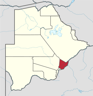
Otse is a village in the South-East District of Botswana. It is located 60 km south of Gaborone, along the Gaborone–Lobatse road and close to the border with South Africa. This village is home to the Balete people who are related to those in Ramotswa, Gabane and Mogobane. The population was 7,636 in 2011 census.

<span class="mw-page-title-main">Chobe District</span> District in Botswana

Chobe District is an administrative district in the northern part of Botswana, with the headquarters in Kasane. In 2001 it was merged with Ngamiland, and until 2006 it shared with Ngamiland the North-West District Council as local government. Chobe National Park is in the Chobe District. As of 2011, the total population of the district was 23,347 compared to 18,258 in 2001. The growth rate of population during the decade was 2.49. The total number of workers constituted 12,059 with 6,113 males and 5,947 females, with majority of them working in public administration.

<span class="mw-page-title-main">Kgosi Gaborone</span>

Gaborone was a kgosi (King) of the Tlokwa, a tribe of the larger Tswana people in what is now Botswana. He became the tribe's King around 1880, after the death of his father, and secured the Tlokwa's status as the "smallest independent tribal unit" in the Bechuanaland Protectorate. He gave his name to the city of Gaborone, Botswana's current capital.

The history of Gaborone began with archaeological evidence in the area around Gaborone dating back to 400 BCE, and the first written accounts of Gaborone are from the earliest European settlers in the 19th century. Since the 1960s, when Botswana gained its independence from Britain and Gaborone became the capital, the city has grown from a small village in the Botswana scrubland to a major center in southern Africa.

Gladys Keitumetse Theresa Kokorwe is a Botswana politician who was the Speaker of the National Assembly from 2014 to 2019. She is a member of the Botswana Democratic Party (BDP).

References

  1. "Sub-national HDI - Area Database - Global Data Lab". hdi.globaldatalab.org. Retrieved 2024-01-13.
  2. Singh (2011). Geography. Tata McGraw-Hill Education. p. 12.53. ISBN   978-0-07-107480-3.
  3. "Tourist attractions in Botswana". Government of Botswana. Retrieved 12 November 2016.
  4. 1 2 "Census of Botswana, 2011". Central Statistics Office of Botswana. 2015. Retrieved 12 November 2016.
  5. "Education details of Botswana, 2011". Central Statistics Office of Botswana. 2015. Archived from the original on 12 November 2016. Retrieved 12 November 2016.
  6. "Labour Force by industry in Botswana, 2008". Central Statistics Office of Botswana. 2008. Archived from the original on 13 November 2016. Retrieved 12 November 2016.
  7. Picard, Louis A. (1979). "Rural Development in Botswana: Administrative Structures and Public Policy". The Journal of Developing Areas. Louis A. Picard. 13 (3): 283–300. JSTOR   4190662.
  8. "Regional and Local government in Botswana". Common Wealth of Nations. Retrieved 12 November 2016.
  9. UN-HABITAT (2002). Local Democracy and Decentralization in East and Southern Africa: Experiences from Uganda, Kenya, Botswana, Tanzania, and Ethiopia. p. 57. ISBN   9789211316667.
  10. Gaotlhobogwe, Monkagedi. "Botswana broken into 19 new sub-districts". MMegi Online. Retrieved 11 November 2016.
  11. "2011 Botswana Population and Housing Census" (PDF). Retrieved 11 September 2013.