North-East District (Botswana)

Last updated
North-East
LSConfluence.jpg
Shashe River centre
Botswana - North-East.svg
Location within Botswana
Coordinates: 21°5′S27°30′E / 21.083°S 27.500°E / -21.083; 27.500
Country Flag of Botswana.svg  Botswana
Capital Francistown
Area
  Total5,120 km2 (1,980 sq mi)
Population
 (2013 census)
  Total167,500
  Density33/km2 (85/sq mi)
Time zone UTC+2 (Central Africa Time)
HDI (2017)0.736 [1]
high · 2nd

The North-East District is one of the administrative districts of Botswana. Its capital is Francistown. In 2011, North-East had a population of 60,264 people. [2] The district is predominantly occupied by Kalanga-speaking people, the BaKalanga. The district is administered by a district administration and district council, which are responsible for local administration.

Contents

In the north and east, the district borders the Matabeleland South Province of Zimbabwe, and the border in the east is predominantly along the Ramokgwebana River. In the south and west, the district borders the Central District along the Shashe River.

Geography

Aerial view of Francistown Francistown 27.51670E 21.16674S.jpg
Aerial view of Francistown

Most parts of Botswana have tableland slopes sliding from east to west. It is predominantly savannah, with tall grasses, bushes, and trees. The region has an average elevation of around 915 m (3,002 ft) above sea level. The annual precipitation is around 65 cm (26 in), most of which is received during the summer season from November to May. There are conflicts between agricultural expansion and the protection of indigenous wildlife within the Central District.

The district has several seasonal rivers that flow in the rainy season and reach the Makgadikgadi Pan. [3] Shashe River, which is prone to flash floods, is the most prominent. [4] The Nata River, which is a significant gathering place for birds and other wildlife, flows through the district and discharges into the Makgadikgadi Pan. [5] [6]

Demographics

Historical population
YearPop.±%
198136,636    
199143,354+18.3%
200149,399+13.9%
201160,264+22.0%
Sources: [2]

According to the Census of Botswana, the district's total population was 60,264 in 2011, up from 49,399 in 2001 (an increase of 21.99%). The annual population growth rate during the decade was 2.01%. The population in the district was 2.98% of the total population in the country. The sex ratio was 90.30 females for every 100 males, compared to 88.29 in 2001. The average household size was 3.11 in 2011, compared to 4.55 in 2001. The total workforce was 10,243 workers, including 2426 craft and related workers; 593 clerks; 3485 elementary occupation workers; 273 legislators, administrators, and managers; 660 plant and machine operators and assemblers, 331 professionals; 1247 service, shop, and market sales workers; 444 skilled agricultural and related workers; and 730 technicians and associated professionals. [2]

Education and economy

Francistown bus station Francistown bus terminal.jpg
Francistown bus station

In 2011, there were a total of 66 schools in the district, with 6.70% private schools. There were 24,296 students in council schools and 1,277 in private schools. 25,572 total students were enrolled in the district: 12,564 girls and 13,008 boys. There were 1058 qualified teachers, 841 female and 217 male. There were around 53 temporary teachers, 34 female and 19 male. There were no untrained teachers in the district. [7] [8]

In 2006, 6881 workers were involved in agriculture, 1529 in construction, 1161 in education, 73 in electricity and water, 61 in finance, 288 in health, 187 in hotels and restaurants, 434 in manufacturing, 784 in mining and quarrying, 97 in other community services, 206 in private households, 1211 in public administration, 271 in real estate, 156 in transport and communications, and 1294 in wholesale and retail trade. There were 14,633 total workers, 7498 female and 7134 male. [9]

District administration

When Botswana gained independence from British colonization in 1966, the country adapted the colonial administrative framework to form a district administration. Between 1970 and 1974, the policies were modified to address impediments to rural development. [10]

The district is administered by a district administration and district council, which are responsible for local administration. The policies for the administration are framed by the Ministry of Local Government. The council's primary activities are Tribal Administration, Remote Area Development, and Local Governance. The executive powers of the council are vested on a commissioner appointed by the central government. The Department of Local Government Technical Services is responsible for developing and maintaining infrastructure, including roads, village water supplies, schools, and recreational facilities. [11] All local administration staff members, except the District Administrator, are selected via Unified Local Government Services. The Ministry of Local Government is responsible for their training, deployment, and career development. [12]

The North-East District has two sub-districts, the Francistown Subdistrict and the North-East Subdistrict. In the 2011 census, 43 villages were listed for the district: Botalaote, Butale, Ditladi, Gambule, Gulubane, Gungwe, Jackalas 1, Jackalas No 2, Kalakamati, Kgari, Letsholathebe, Mabudzane, Makaleng, Mambo, Mapoka, Masingwaneng, Masukwane, Masunga, Maitengwe, Matopi, Matshelagabedi, Matsiloje, Mbalambi, Moroka, Mosojane, Mowana, Mulambakwena, Nlakhwane, Patayamatebele, Pole, Ramokgwebana, Sechele, Sekakangwe, Senyawe, Shashe Bridge, Siviya, Tati Siding, Themashanga, Toteng, Tsamaya, Tshesebe, Vukwi, and Zwenshambe. [13]

See also

Related Research Articles

<span class="mw-page-title-main">Kgalagadi District</span> District in Botswana

Kgalagadi is a district in southwest Botswana, lying along the country's border with Namibia and South Africa. The administrative center is Tsabong. The district of Kgalagadi covers a large part of the Kalahari Desert. It has a total area of 105,200 km² and has a population of 42,000 (2001). More than one-third of the district is covered by the Kgalagadi Transfrontier Park, which extends into South Africa, and which is a major tourist attraction.

<span class="mw-page-title-main">Francistown</span> City in North-East District, Botswana

Francistown is the second-largest city in Botswana, with a population of about 103,417 and 147,122 inhabitants for its agglomeration at the 2022 census. It is located in eastern Botswana, about 400 kilometres (250 mi) north-northeast from the capital, Gaborone. Francistown is located at the confluence of the Tati and Ntshe rivers, and near the Shashe River and 90 kilometres (56 mi) from the international border with Zimbabwe.

<span class="mw-page-title-main">Ghanzi District</span> District in Botswana

Ghanzi is a district in western Botswana, bordering Namibia in the west and extending east into much of the interior of the country. The district's administrative centre is the town of Ghanzi. Most of the eastern half of Ghanzi makes up the Central Kalahari Game Reserve. The human population at the 2001 census was 43,370, less populous than that of any other district in Botswana. Ghanzi's area is 117,910 km².

<span class="mw-page-title-main">Southern District (Botswana)</span> District in Botswana

Southern is one of the districts of Botswana. The capital of Southern district is Kanye, home to the Bangwaketse and Barolong in Botswana. The Southern district is home to Botswana's second largest beef farmers where there are large privately owned ranges, and several government run beef ranges which provide agricultural support to the local farmers. Maize and sorghum, Botswana's staple crop, are also raised in the area. Southern district is where the third diamond mine of Botswana was found, which buoys Botswana's economic state of prosperity. It was the first district to house the capital city before being moved to Gaborone after independence.

<span class="mw-page-title-main">Kweneng District</span> District in Botswana

Kweneng is one of the districts of Botswana and is the recent historical homeland of the Bakwena people, the first group in Botswana converted to Christianity by famed missionary David Livingstone. Various landmarks, including Livingstone's Cave, allude to this history. The seat of the district's government is Molepolole, Botswana's most populous village.

<span class="mw-page-title-main">North-West District (Botswana)</span> District in Botswana

The North-West District or Ngamiland is one of the first-level administrative subdivisions of Botswana. For census and administrative purposes Ngamiland is subdivided into Ngamiland East, Ngamiland West and Ngamiland Delta (Okavango). It is governed by a District Commissioner, appointed by the national government, and the elected North-West District Council. The administrative centre is Maun.

<span class="mw-page-title-main">Kgatleng District</span> District in Botswana

Kgatleng is one of the districts of Botswana, coterminous with the homeland of the Bakgatla people. Its capital is Mochudi, the hometown of protagonist Precious Ramotswe in Alexander McCall Smith's popular The No. 1 Ladies' Detective Agency series. According to the 2001 Census, Kgatleng had a population of 73,507 people.

<span class="mw-page-title-main">South-East District (Botswana)</span> District in Botswana

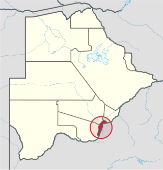
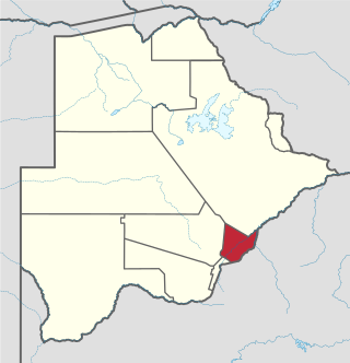
South-East is one of the districts of Botswana. The capital city of Botswana, Gaborone, is surrounded by this district. The administrative capital for the South-East district is the village of Ramotswa. In the southeast, South-East borders the North West Province of South Africa. Domestically, it borders Kgatleng in northeast, Kweneng in northwest, Southern in southwest.

<span class="mw-page-title-main">Central District (Botswana)</span> District in Botswana

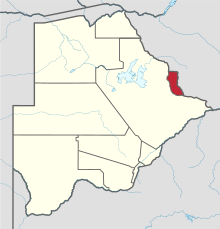
Central is the largest of Botswana's districts in terms of area and population. It encompasses the traditional homeland of the Bamangwato people. Some of the most politically connected Batswana have come from the Central District, including former President Sir Seretse Khama, former President Festus Mogae, and former President Lt. General Seretse Ian Khama. The district borders the Botswanan districts of Chobe in the north, North-West in the northwest, Ghanzi in the west, Kweneng in southwest, Kgatleng in the south and North-East in the northeast, as well as Zimbabwe also in the northeast and South Africa in the southeast.

<span class="mw-page-title-main">Tonota</span> Village located in the Central District of Botswana

Tonota is a village located in the Central District of Botswana.

<span class="mw-page-title-main">Tutume</span> Village in Central District, Botswana

Tutume is a large Bakalanga village located in the Central District of Botswana, about 50 km from the Zimbabwe border gate at Maitengwe. The nearest city is Francistown, about 100 km away. The village is a district headquarters and has a population of 23,000 .It is made up of wards: Sitabule(Madikwe),Tjilagwani(Selolwane), Thini and Madandume (Magapatona). In each ward there is a headman and his advisers in the kgotla. The main kgotla is located in Madikwe ward near Tutume Central Primary School. The village was named after the river "TUTUME", in Kalanga they will say "gwizi go Tutuma", meaning that the river was overflowing.

Plumtree is a town in Zimbabwe. Marula trees, wild plum trees grow abundantly in the area. The town was once called Getjenge by baKalanga. Another name by which it is often caled, is Titji, meaning station and referring to the railway station which was operating in the area around 1897.

<span class="mw-page-title-main">Shashe River</span> River in Botswana, Zimbabwe

The Shashe River is a major left-bank tributary of the Limpopo River in Zimbabwe. It rises northwest of Francistown, Botswana and flows into the Limpopo River where Botswana, Zimbabwe and South Africa meet. The confluence is at the site of the Greater Mapungubwe Transfrontier Conservation Area.

Mathangwane is a village in the Central District of Botswana administered under Tutume Sub-district Council. The village is located at the confluence of the Shashe and Vukwi rivers, 25 kilometres west of the City of Francistown along the A3 highway and almost entirely on the left bank of Shashe River. The population of the village was 5,075 in the 2011 national population and housing census. The village is characterised by many river valleys, mostly tributaries to Shashe River and used for identifying the village community wards (dikgotlana) boundaries.

<span class="mw-page-title-main">Kalanga people</span> Bantu ethnic group

The Kalanga or BaKalanga are a southern Bantu ethnic group mainly inhabiting Matebeleland in Zimbabwe, northern Botswana, and parts of the Limpopo Province in South Africa.

<span class="mw-page-title-main">Chobe District</span> District in Botswana

Chobe District is an administrative district in the northern part of Botswana, with the headquarters in Kasane. In 2001 it was merged with Ngamiland, and until 2006 it shared with Ngamiland the North-West District Council as local government. Chobe National Park is in the Chobe District. As of 2011, the total population of the district was 23,347 compared to 18,258 in 2001. The growth rate of population during the decade was 2.49. The total number of workers constituted 12,059 with 6,113 males and 5,947 females, with majority of them working in public administration.

Mandunyane is named after Kgosi Harry Mandunyane I, who ruled since 1973 when the village was established. The village is located in the Central District of Botswana in Tonota subdistrict. It is approximately 8 km (5.0 mi) north west of Tonota and roughly 30 km (19 mi) south west of Francistown.

The Ramokgwebana River is a river that defines part of the boundary between Botswana and Zimbabwe before entering the Shashe River from the left.

Zwenshambe is a village in the North-East District of Botswana. It is situated between Gungwe village in the west, Nlapkhwane village in the east, Mulambakwena village in the south and the Zimbabwe border in the north. It is not far from the Ramokgwebana Border Post. The nearest city to Zwenshambe is Francistown which is also the second largest city in Botswana.

References

  1. "Sub-national HDI - Area Database - Global Data Lab". hdi.globaldatalab.org. Retrieved 2018-09-13.
  2. 1 2 3 "Census of Botswana, 2011". Central Statistics Office of Botswana. 2015. Retrieved 29 July 2019.
  3. Petter, Jan; Hansen, Huberth; Lillethun, Arvid. Resource utilization in the Central District CFDA, Botswana: with special reference to arable farming systems and conflicts in resource management - livestock versus wildlife.
  4. Singh (2011). Geography. Tata McGraw-Hill Education. p. 12.53. ISBN   978-0-07-107480-3.
  5. Cashdan, Elizabeth (1986). "Competition between Foragers and Food-Producers on the Botletli River, Botswana". Journal of the International African Institute. 56 (3): 299–318. doi:10.2307/1160686. JSTOR   1160686.
  6. Hogan, C. Michael (2008). Burnham, Andy (ed.). Makgadikgadi. The Megalithic Portal.
  7. "Education details of Botswana, 2011". Central Statistics Office of Botswana. 2015. Archived from the original on 12 November 2016. Retrieved 29 July 2019.
  8. "Education statistics" (PDF). 2015-10-16. Archived from the original (PDF) on 2015-10-16. Retrieved 2019-07-29.
  9. "Labour Force by industry in Botswana, 2008". Central Statistics Office of Botswana. 2008. Archived from the original on 13 November 2016. Retrieved 12 November 2016.
  10. Picard, Louis A. (1979). "Rural Development in Botswana: Administrative Structures and Public Policy". The Journal of Developing Areas. Louis A. Picard. 13 (3): 283–300. JSTOR   4190662.
  11. "Regional and Local government in Botswana". Common Wealth of Nations. Archived from the original on 18 January 2014.
  12. Kinuthia-Njenga, Cecilia; et al. (2002). Local Democracy and Decentralization in East and Southern Africa: Experiences from Uganda, Kenya, Botswana, Tanzania, and Ethiopia. Nairobi, Kenya: Global Campaign on Urban Governance, United Nations Human Settlements Programme. p. 57. ISBN   978-92-1-131666-7.
  13. "2011 Botswana Population and Housing Census" (PDF). Botswana Central Statistics Office. Archived from the original (PDF) on 23 September 2015.