
Botswana, officially the Republic of Botswana, is a landlocked country in Southern Africa. Botswana is topographically flat, with up to 70 percent of its territory being the Kalahari Desert. It is bordered by South Africa to the south and southeast, Namibia to the west and north, and Zimbabwe to the northeast. It is connected to Zambia across the short Zambezi River border by the Kazungula Bridge.

Kgalagadi is a district in southwest Botswana, lying along the country's border with Namibia and South Africa. The administrative center is Tsabong. The district of Kgalagadi covers a large part of the Kalahari Desert. It has a total area of 105,200 km² and has a population of 42,000 (2001). More than one-third of the district is covered by the Kgalagadi Transfrontier Park, which extends into South Africa, and which is a major tourist attraction.

Kang is a village in Kgalagadi District of Botswana. It is situated in the Kalahari Desert and lies on the Trans-Kalahari Highway between Ghanzi in the north and Sekoma in the south. Kang also provides access to the Kgalagadi Transfrontier Park in the south-west and the Central Kalahari Game Reserve in the north-east. The route via Ghanzi takes one to the Namibian border, whilst that to Sekoma leads to Gaborone, the capital of Botswana. The population was 5,985 according to the 2011 census. Kang also falls under the Kgalagadi North constituency whose Member of Parliament is Hon. Phillip Khwae. The village is divided into two wards, Kang North and Kang South.

Ghanzi is a district in western Botswana, bordering Namibia in the west and extending east into much of the interior of the country. The district's administrative centre is the town of Ghanzi. Most of the eastern half of Ghanzi makes up the Central Kalahari Game Reserve. The human population at the 2001 census was 43,370, less populous than that of any other district in Botswana. Ghanzi's area is 117,910 km².

Southern is one of the districts of Botswana. The capital of Southern district is Kanye, home to the Bangwaketse and Barolong in Botswana. The Southern district is home to Botswana's second largest beef farmers where there are large privately owned ranges, and several government run beef ranges which provide agricultural support to the local farmers. Maize and sorghum, Botswana's staple crop, are also raised in the area. Southern district is where the third diamond mine of Botswana was found, which buoys Botswana's economic state of prosperity. It was the first district to house the capital city before being moved to Gaborone after independence.

The North-East District is one of the administrative districts of Botswana. Its capital is Francistown. In 2011, North-East had a population of 60,264 people. The district is predominantly occupied by Kalanga-speaking people, the BaKalanga. The district is administered by a district administration and district council, which are responsible for local administration.

Kweneng is one of the districts of Botswana and is the recent historical homeland of the Bakwena people, the first group in Botswana converted to Christianity by famed missionary David Livingstone. Various landmarks, including Livingstone's Cave, allude to this history. The seat of the district's government is Molepolole, Botswana's most populous village.

The North-West District or Ngamiland is one of the first-level administrative subdivisions of Botswana. For census and administrative purposes Ngamiland is subdivided into Ngamiland East, Ngamiland West and Ngamiland Delta (Okavango). It is governed by a District Commissioner, appointed by the national government, and the elected North-West District Council. The administrative centre is Maun.
Kgatleng is one of the districts of Botswana, coterminous with the homeland of the Bakgatla people. Its capital is Mochudi, the hometown of protagonist Precious Ramotswe in Alexander McCall Smith's popular The No. 1 Ladies' Detective Agency series. According to the 2001 Census, Kgatleng had a population of 73,507 people.

South-East is one of the districts of Botswana. The capital city of Botswana, Gaborone, is surrounded by this district. The administrative capital for the South-East district is the village of Ramotswa. In the southeast, South-East borders the North West Province of South Africa. Domestically, it borders Kgatleng in northeast, Kweneng in northwest, Southern in southwest.

Central is the largest of Botswana's districts in terms of area and population. It encompasses the traditional homeland of the Bamangwato people. Some of the most politically connected Batswana have come from the Central District, including former President Sir Seretse Khama, former President Festus Mogae, and former President Lt. General Seretse Ian Khama. The district borders the Botswanan districts of Chobe in the north, North-West in the northwest, Ghanzi in the west, Kweneng in southwest, Kgatleng in the south and North-East in the northeast, as well as Zimbabwe also in the northeast and South Africa in the southeast.

Kasane is a town in Botswana, close to Africa's 'Four Corners', where four countries almost meet: Botswana, Namibia, Zambia and Zimbabwe. It is at the far north-eastern corner of Botswana where it serves as the administrative center of the Chobe District. The population of Kasane was 9,244 in 2011 census.

Letlhakane is a village in the Central District of Botswana. Letlhakane is the headquarters of the Boteti sub-district. It is located south of Mmatshumo and the population of the village was 22,911 in 2011 census.
The districts of Botswana are subdivided into sub-districts. The sub-districts are listed below, by district:
Khisa or Kisa is a village in Kgalagadi District of Botswana. It is located close to the border with South Africa, north-east of the district capital Tshabong. The population was 383 in 2011 census.
Omaweneno is a village in Kgalagadi District of Botswana. It is located north-east of the district capital, Tshabong. The population was 917 in 2011 census.
Phepheng, also known as Phepeng, Draaihoek or Draihoek, is a village in Kgalagadi District of Botswana. It is located north-east of the district capital Tshabong. The population was 994 in the 2011 census.

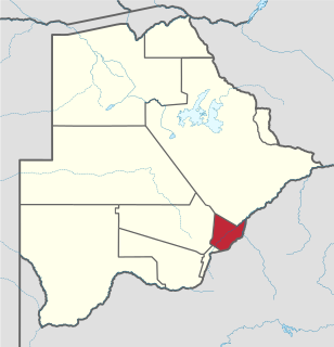
Chobe District is an administrative district in the northern part of Botswana, with the headquarters in Kasane. In 2001 it was merged with Ngamiland, and until 2006 it shared with Ngamiland the North-West District Council as local government. Chobe National Park is in the Chobe District. As of 2011, the total population of the district was 23,347 compared to 18,258 in 2001. The growth rate of population during the decade was 2.49. The total number of workers constituted 12,059 with 6,113 males and 5,947 females, with majority of them working in public administration.
Kgari is a village in the North-East District of Botswana. In 2001, the population was 581. In 2011, the population was 534.
Vukwi is a village in the North-East District of Botswana. In 2001, the population was 263. In 2011, the population was 369.
