Districts of Botswana

Last updated

Districts of Botswana
Districts of Botswana (image map).svg 
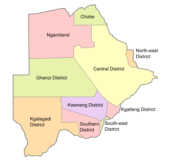
Districts of Botswana. The seven urban districts are not shown.
Category Unitary State
Location Republic of Botswana
Number17 Districts
Populations2,914 (Sowa) – 652,085 (Central District)
Areas17 km2 (6.6 sq mi) (Orapa) – 142,076 km2 (54,856 sq mi) (Central District)
Government
  • District government
Subdivisions

Botswana is divided into 10 administrative districts, two cities, five towns and 11 sub districts. These are administered by 16 local authorities (district councils, city councils or town councils). [1] [2] [3]

Administrative DistrictCapitalPopulation 2022Population 2011Area (km2)Density 2011 (/km2)
Southern District Kanye 240,544215,77528,4707.5790
South-East District Ramotswa 385,038345,6131,780194.2
Kweneng District Molepolole 387,703304,54931,1009.793
Kgatleng District Mochudi 121,41191,6607,96011.515
Central District Serowe 700,908576,064638,6040.9020676
North-East District Masunga 171,354159,2255,12031.099
Ngamiland District Maun 196,574152,284109,1301.39544
Chobe District Kasane 28,38823,34720,8001.1225
Ghanzi District Ghanzi 55,88443,355117,9100.367696
Kgalagadi District Tsabong 58,37550,492105,2000.47996
Total2,359,6092,024,904570,1623.551454

See also

Related Research Articles

<span class="mw-page-title-main">Gaborone</span> Capital and the largest city of Botswana

Gaborone is the capital and largest city of Botswana with a population of 246,325 based on the 2022 census, about 10% of the total population of Botswana. Its agglomeration is home to 421,907 inhabitants at the 2011 census.

<span class="mw-page-title-main">Dinapigue</span> Municipality in Isabela, Philippines

Dinapigue, officially the Municipality of Dinapigue, is a 1st class municipality in the province of Isabela, Philippines. According to the 2020 census, it has a population of 5,821 people.

<span class="mw-page-title-main">Kayapa</span> Municipality in Nueva Vizcaya, Philippines

Kayapa, officially the Municipality of Kayapa, is a 3rd class municipality in the province of Nueva Vizcaya, Philippines. According to the 2020 census, it has a population of 26,469 people.

<span class="mw-page-title-main">Subic, Zambales</span> Municipality in Zambales, Philippines

Subic, officially the Municipality of Subic, is a 1st class municipality in the province of Zambales, Philippines. According to the 2020 census, it has a population of 111,912 people.

<span class="mw-page-title-main">Bokod, Benguet</span> Municipality in Benguet, Philippines

Bokod, officially the Municipality of Bokod,, is a 4th class municipality in the province of Benguet, Philippines. According to the 2020 census, it has a population of 14,435 people.

<span class="mw-page-title-main">Itogon</span> Municipality in Benguet, Philippines

Itogon, officially the Municipality of Itogon,, is a 1st class municipality in the province of Benguet, Philippines. According to the 2020 census, it has a population of 61,498 people.

<span class="mw-page-title-main">Kabayan, Benguet</span> Municipality in Benguet, Philippines

Kabayan, officially the Municipality of Kabayan, is a 4th class municipality in the province of Benguet, Philippines. According to the 2020 census, it has a population of 15,806 people.

<span class="mw-page-title-main">Mankayan</span> Municipality in Benguet, Philippines

Mankayan, officially the Municipality of Mankayan, is a 1st class municipality in the province of Benguet, Philippines. According to the 2020 census, it has a population of 37,233 people.

<span class="mw-page-title-main">Southern District (Botswana)</span> District in Botswana

Southern is one of the districts of Botswana. The capital of Southern district is Kanye, home to the Bangwaketse and Barolong in Botswana. The Southern district is home to Botswana's second largest beef farmers where there are large privately owned ranges, and several government run beef ranges which provide agricultural support to the local farmers. Maize and sorghum, Botswana's staple crop, are also raised in the area. Southern district is where the third diamond mine of Botswana was found, which buoys Botswana's economic state of prosperity. It was the first district to house the capital city before being moved to Gaborone after independence.

<span class="mw-page-title-main">North-East District (Botswana)</span> District in Botswana

The North-East District is one of the administrative districts of Botswana. Its capital is Francistown. In 2011, North-East had a population of 60,264 people. The district is predominantly occupied by Kalanga-speaking people, the BaKalanga. The district is administered by a district administration and district council, which are responsible for local administration.

<span class="mw-page-title-main">North-West District (Botswana)</span> District in Botswana

The North-West District or Ngamiland is one of the first-level administrative subdivisions of Botswana. For census and administrative purposes Ngamiland is subdivided into Ngamiland East, Ngamiland West and Ngamiland Delta (Okavango). It is governed by a District Commissioner, appointed by the national government, and the elected North-West District Council. The administrative centre is Maun.

<span class="mw-page-title-main">South-East District (Botswana)</span> District in Botswana

South-East is one of the districts of Botswana. The capital city of Botswana, Gaborone, is surrounded by this district. The administrative capital for the South-East district is the village of Ramotswa. In the southeast, South-East borders the North West Province of South Africa. Domestically, it borders Kgatleng in northeast, Kweneng in northwest, Southern in southwest.

<span class="mw-page-title-main">Gumare</span>

Gumare or Gomare is a rural village located in the North-West District of Botswana, near the Okavango Delta. The population of Gumare was 6,067 in 2001 census, but had risen to 8,532 iby the 2011 census.

Kanye is a village in southern Botswana, located 83 kilometres (52 mi) south-west of the capital, Gaborone. It is the administrative centre of the Southern District, and had a population of 48,028 as of the 2022 Population and Housing Census. There is an increase comparing to the 45,196 of the 2011 census, making it the ninth-largest village in the country. Kanye is the traditional capital of the Ngwaketse tribe, who first settled in the area in the 1790s. The village is the longest continuously occupied tribal capital in the country.

<span class="mw-page-title-main">Ampara District</span> Administrative District in Eastern, Sri Lanka

Ampara District is one of the 25 districts of Sri Lanka, the second-level administrative divisions of the country. The district is administered by a District Secretariat headed by a District Secretary appointed by the central government of Sri Lanka. The capital of the district is the town of Ampara. The district was carved out of the southern part of Batticaloa District in April 1961.

<span class="mw-page-title-main">Kiambu County</span> Place in Kenya

Kiambu County is a county in the former Central Province of Kenya. Its capital is Kiambu and its largest town is Thika town. Kiambu County is the second most populous after Nairobi County. Kiambu County borders Nairobi and Kajiado Counties to the South, Machakos to the East, Murang'a to the North and North East, Nyandarua to the North West, and Nakuru to the West and has a population of 2,417,735.

<span class="mw-page-title-main">Batticaloa District</span> Administrative District in Eastern, Sri Lanka

Batticaloa District is one of the 25 districts of Sri Lanka, the second level administrative division of the country. The district is administered by a District Secretariat headed by a District Secretary appointed by the central government of Sri Lanka. The capital of the district is the city of Batticaloa. Ampara District was carved out of the southern part of Batticaloa District in April 1961.

<span class="mw-page-title-main">Census in Botswana</span> Nationwide decennial census

ThePopulation and Housing Census is a decennial census which is the once-a-decade population and housing count of all people in Botswana. This count is carried out by the Statistics Botswana.

Statistics Botswana (StatsBots) is the National statistical bureau of Botswana. The organization was previously under the Ministry of Finance and development planning as a department and was called Central Statistics Office. The organisation was initially set up in 1967 through an Act of Parliament – the Statistics Act and thereafter transformed into a parastatal through the revised Statistics Act of 2009. This act gives the Statistics Botswana the mandate and authority to collect, process, compile, analyse, publish, disseminate and archive official national statistics. It is also responsible for "coordinating, monitoring and supervising the National Statistical System" in Botswana. The office has its main offices in Gaborone and three satellite offices in Maun, Francistown and Ghanzi. The different areas in statistics that should be collected are covered under this Act and are clearly specified. The other statistics that are not specified can be collected as long as they are required by the Government, stakeholders and the users.

References

  1. "2011 Population & Housing Census Analytical Report" (PDF). Archived from the original (PDF) on 30 October 2017. Retrieved 17 July 2017.
  2. "Botswana Government Ministries & Authorities". Archived from the original on 6 June 2017.
  3. "2022 Population and Housing Census Preliminary Results" (PDF). Statistics Botswana.
  4. Statistics, Botswana. "Statistics Botswana Website". Statistics Botswana.