| States of Nigeria | |
|---|---|
 | |
| Category | Federated states |
| Location | Federal Republic of Nigeria |
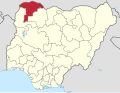
| Number | 36 |
| Populations | 1,704,358 (Bayelsa State) – 9,401,288 (Kano State) Mean: 5,300,000 |
| Areas | 3,580 km2 (1,381 sq mi) (Lagos State) – 76,360 km2 (29,484 sq mi) (Niger State) Mean: 25,660 km2 (9,907 sq mi) |
| Government | |
| Subdivisions |
|
 |
|---|
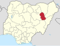
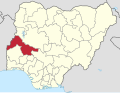
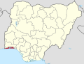
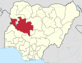
Nigeria is a federation of 36 states, each of which is a semi-autonomous political unit that shares power with the federal government as enumerated under the Constitution of the Federal Republic of Nigeria. In addition to the states, there is the Federal Capital Territory (FCT), in which the capital city of Abuja is located. [1] The FCT is not a state, but a territory of the federal government, governed by an administration headed by a minister. Each state is subdivided into local government areas (LGAs). There are 774 local governments in Nigeria. [2] Under the Nigerian Constitution, the 36 states enjoy substantial autonomy but are not sovereign entities, as ultimate authority lies with the federal government. Amendments to the constitution can be proposed by the National Assembly, but for an amendment to be valid, it must be approved by a two-third majority of the 36 state legislatures, as required under Section 9 of the 1999 Constitution of Nigeria. [3]