Uyo | |
|---|---|
City | |
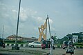
 Roundabout at Wellington Bassey Road | |
| Motto: Land of Promise | |
 Interactive map of Uyo | |
 Uyo | |
| Coordinates: 5°02′00″N7°55′39″E / 5.03333°N 7.92750°E | |
| Country | |
| State | Akwa Ibom |
| Government | |
| • Type | State Capital |
| • Chairman | Dr. Uwemedimo Udo |
| Area | |
• City | 362 km2 (140 sq mi) |
| Population (2006 census) [1] | |
• City | 427,873 |
| • Density | 1,180/km2 (3,060/sq mi) |
| • Urban | 554,906 |
| GDP (PPP, 2015 int. Dollar) | |
| • Year | 2023 |
| • Total | $12.4 billion [2] |
| • Per capita | $9,300 |
| Time zone | UTC+1 (WAT) |
| Postal code | 520001 |
| Area code | 085 |
| Vehicle registration | UYY |
| Climate | Am |
| Website | http://akwaibomstate.gov.ng |
Uyo is the capital of Akwa Ibom state located in South South, Nigeria. [3] [4] It became the capital on September 23, 1987 when Akwa Ibom was created from the former Cross River State. [5] According to the 2006 Nigerian Census, the population of Uyo (including Itu) is 427,873, [6] while the greater urban area, including Uruan, has a population of 554,906. [7] The population of Uyo is put at 1,393,000 as at 2024. [8]
Contents
- Education
- Infrastructure
- Transportation
- Waste management
- Sports
- Religion
- Climate
- Wind
- Gallery
- See also
- References
Ibibio is the primary indigenous language. [9] The main campus of the University of Uyo is in Nwaniba, with satellites on Ikpa Road. [10] Ibom Air has its head office in Uyo.