Lafia

Last updated

Lafia
Lafiyan
LGA and city
Lafia.jpg
Nickname: 
Lafia Garin Madidi
Nigeria location map.svg
Red pog.svg
Lafia
Coordinates: 8°29′30″N8°31′0″E / 8.49167°N 8.51667°E / 8.49167; 8.51667
CountryFlag of Nigeria.svg  Nigeria
State Nasarawa State
Government
   Emir Hon. Justice Sidi Bage Muhammad I JSC Rtd.
   LGA Chairman Alh. Aminu Mu'azu Maifata
Area
  Total1,092 sq mi (2,827 km2)
Population
 (2022 est) [1]
  Total509,300
  Density470/sq mi (180/km2)
Time zone UTC1 (WAT)
Climate Aw

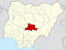
Lafia is a city in Nigeria's North Central region. It is the capital and largest city of Nasarawa State, with a population of 330,712 inhabitants as of the 2006 census.

Contents

History

Lafia, also known as Lafian bare-bari, is the capital city of Nasarawa State, North Central Nigeria. Founded by Muhammadu Dunama in late 17th century on the site south of Shabu village. The town now has its 17th Emir in the person of Hon. Justice Sidi Bage Muhammad I JSC rtd. Lafia became the capital of a prominent local chiefdom in the late 19th century. During the rule of Mohamman Agwai (1881–1903), the Lafia market became one of the most important in the Benue Valley, and a trade route was opened to Loko (56 mi [90 km] southwest), a Benue River port. In 1903, the British, who controlled Northern Nigeria recognized Chief Musa as Lafia's first emir. The emirate formed the major part of the Lafia Division of Benue province. In 1967, the town became part of Benue-Plateau state, and in 1976, it was allocated to Plateau state. The original inhabitants of Lafia are mainly by the Kanuri, Fulani Gwandara, Alago, Migilli (Koro). It also has large populations of Hausa. This is due to the hospitable nature of the indigenes and has made the city a miniature Nigeria.

Modern Lafia aside from being an administrative and educational centre, it is also a collecting point for sesame seeds, soybeans, and is a trading centre for yams, sorghum, millet, and cotton. Besides farming, cotton weaving and dyeing are traditionally important activities of the town's inhabitants. Livestock farming is also a prominent activity especially amongst the Fulani herdsmen.

The two royal families of Ari and Dallah Dunama of the Kanuri people (Bare-Bari) are the ruling houses of the Lafia Emirate. The current Emir is Sidi Bage, from the Dallah Dunama royal family. He succeeded the longest reigning Emir, HRH Isa Mustapha Agwai I (1976–2019). [2] [3] [4]


LAFIA CENTRAL MOSQUE

Thehe 
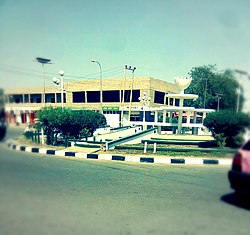
Lafia Central Mosque (Arabic: النصراوا لافيا), also known as the Nasarawa State Mosque, is the state mosque of Nasarawa. The mosque was built in 1971[1] and is open to the non-Muslim public, except during congregational prayers.

Institutions

Lafia is home to the Federal University of Lafia, Nasarawa State University Faculty of Agriculture Lafia Campus, Isa Mustapha Agwai I Polytechnic Lafia, School of Nursing And Midwifery, School of Health Technology LAFIA, College of Agriculture Lafia, and a study centre of the National Open University of Nigeria. It has a large number of primary and secondary schools. The St Williams Cathedral, situated along Jos Road, is the headquarters of the Lafia diocese and still under construction.

It is situated on the trunk railway from Port Harcourt and on the main highway between Makurdi and Jos. The population per the 2006 census in Lafia local government area was estimated as 330,712. [5]

Climate

Lafia has hot, humid, partly cloudy dry seasons, oppressive, overcast rainy seasons, with temperatures that range from 64°F to 97°F all year round. It rarely gets below 59°F or rises over 103°F. [6] [7] [8]

Climate data for Lafia (1991–2020)
MonthJanFebMarAprMayJunJulAugSepOctNovDecYear
Record high °C (°F)40
(104)
42
(108)
42.2
(108.0)
42
(108)
40
(104)
36.8
(98.2)
34.5
(94.1)
41
(106)
35
(95)
37
(99)
40
(104)
39
(102)
42.2
(108.0)
Mean daily maximum °C (°F)35.6
(96.1)
37.6
(99.7)
38.2
(100.8)
36.2
(97.2)
33.5
(92.3)
31.6
(88.9)
30.6
(87.1)
30.0
(86.0)
30.8
(87.4)
32.4
(90.3)
35.2
(95.4)
35.6
(96.1)
33.9
(93.0)
Daily mean °C (°F)27.3
(81.1)
30.1
(86.2)
32.0
(89.6)
30.9
(87.6)
29.0
(84.2)
27.6
(81.7)
26.9
(80.4)
26.5
(79.7)
26.8
(80.2)
27.8
(82.0)
28.1
(82.6)
26.8
(80.2)
28.3
(82.9)
Mean daily minimum °C (°F)19.0
(66.2)
22.6
(72.7)
25.8
(78.4)
25.7
(78.3)
24.5
(76.1)
23.5
(74.3)
23.2
(73.8)
23.0
(73.4)
22.9
(73.2)
23.2
(73.8)
21.0
(69.8)
18.0
(64.4)
22.7
(72.9)
Record low °C (°F)11
(52)
10.8
(51.4)
15
(59)
18
(64)
17
(63)
16
(61)
19.7
(67.5)
18.2
(64.8)
19
(66)
17
(63)
13.5
(56.3)
10.5
(50.9)
10.5
(50.9)
Average precipitation mm (inches)1.6
(0.06)
4.8
(0.19)
12.4
(0.49)
87.2
(3.43)
157.1
(6.19)
214.8
(8.46)
239.1
(9.41)
309.0
(12.17)
235.7
(9.28)
143.6
(5.65)
5.1
(0.20)
0.1
(0.00)
1,410.4
(55.53)
Average precipitation days (≥ 1.0 mm)0.10.30.84.47.910.112.114.413.48.00.50.072.1
Average relative humidity (%)37.438.852.469.078.682.784.786.385.682.963.345.167.2
Source: NOAA [9]

Temperature

From January through April, Lafia endures a hot season with daily highs typically exceeding 94°F. The hottest month is March, which averages highs of 97°F and lows of 75°F. Highs below 86°F are experienced for 4.0 months during the chilly season. The coldest month is December, which has highs of 90°F and lows of 65°F. [6] [7]

Growing Period

In Lafia, the term "growing season" refers to the longest stretch of time of the year during which temperatures are not below freezing (32°F). With a base of 50°F and a top of 86°F, growing degree days are a measurement of yearly heat accumulation used to forecast plant and animal development. [6]

Sports

Lafia is the location of Nasarawa United, a football club whose stadium is Lafia Township Stadium.

Transportation

Lafia is served by the main narrow gauge railway from Port Harcourt.

See also

Related Research Articles

Yola, meaning 'Great Plain' or 'Vast Plain Land', is a large city, capital city and administrative centre of Adamawa State, Nigeria. It is located on the Benue River, and it has a population of over 336,648 (2010). Yola is split into two parts. The old town of Yola where the Lamido resides is the traditional city and the new city of Jimeta is the administrative and commercial centre. They are generally referred to as Yola.

<span class="mw-page-title-main">Gombe State</span> State of Nigeria

Gombe State is a state in northeastern Nigeria, bordered to the north and northeast by the states of Borno for 93 km in the vicinity of Gongola River and Lake Dadin Kowa and Yobe in the vicinity of Gongola River for 140 km, to the south by Taraba State for 58 km, to the southeast by Adamawa State for 95 km, and to the west by Bauchi State for 277 km. Gombe is the state capital of Gombe state and it was formed from a part of Bauchi State on 1 October 1996. Of the 36 states in Nigeria, Gombe is the 21st largest in area and the 32nd most populous, with an estimated population of about 3.25 million as of 2016. The state bears a slogan "Jewel in the Savannah".

<span class="mw-page-title-main">Benue State</span> State of Nigeria

Benue State is one of the North Central states in Nigeria with a population of about 4,253,641 in 2006 census. The state was created in 1976 among the seven states created at that time. The state derives its name from the Benue River which is the second largest river in Nigeria after the River Niger. The state borders Nasarawa State to the North; Taraba State to the East; Kogi State to the West; Enugu State to the South-West; Ebonyi and Cross-Rivers State to the South; and has an international border with Cameroon to the South-East. It is inhabited predominantly by the Tiv, Idoma, and Igede. Minority ethnic groups in Benue are Etulo, Igbo, Jukun peoples etc. Its capital is Makurdi. Benue is a rich agricultural region; popularly grown crops include: oranges, mangoes, sweet potatoes, cassava, soya bean, guinea corn, flax, yams, sesame, rice, groundnuts, and Palm tree.

<span class="mw-page-title-main">Plateau State</span> State of Nigeria

Plateau State is the twelfth largest Nigerian state by area. It is located near the centre of Nigeria and includes a range of hills surrounding the Jos Plateau, its capital, and the entire plateau itself. Plateau State is described as "The Home of Peace and Tourism". With natural formations of rocks, hills and waterfalls, it derives its name from the Jos Plateau and has a population of around 4.7 million people.

<span class="mw-page-title-main">Bauchi State</span> State of Nigeria

Bauchi State is a state in the North-East geopolitical zone of Nigeria, bordered by Jigawa to the north, Yobe to the northeast, Gombe to the east, Taraba and Plateau to the south, Kaduna to the west and Kano to the northwest. It takes its name from the historic town of Bauchi, which also serves as its capital city. The state was formed in 1976 when the former North-Eastern State was broken up. It originally included the area that is now Gombe State, which became a distinct state in 1996.

<span class="mw-page-title-main">Nasarawa State</span> State of Nigeria

Nasarawa State is a state in the North Central region of Nigeria, bordered to the east by the states of Taraba and Plateau, to the north by Kaduna State, to the south by the states of Benue and Kogi, and to the west by the Federal Capital Territory. Named for the historic Nasarawa Emirate, the state was formed from the west of Plateau State on 1 October 1996. The state has thirteen local government areas and its capital is Lafia, located in the east of the state, while a key economic centre of the state is the Karu Urban Area—suburbs of Abuja—along the western border with the FCT.

Haɗejiya is a Hausa town in eastern Jigawa State, northern Nigeria. The population was approximately 105,628 in 2006. Hadejia lies between latitude 12.4506N and longitude 10.0404E. It shared boundary with Kiri Kasama Local Government from the East, Mallam Maɗori Local Government from the North, and Auyo Local Government from the West. The Hadejia Local Government consist of eleven (11) political wards namely: Atafi, Dubantu, Gagulmari, Kasuwar Ƙofa, Kasuwar Kuda, Matsaro, Majema, Rumfa, Sabon Garu, Ƴankoli and Yayari. Inhabitants are dominantly Hausa, Fulani and Kanuri with some other groups such as Tiv, Yoruba, Igbo, Igala etc. The dominant occupation of the inhabitants is crop-farming and animal rearing which a considerable percentage, engaged in trading, fishing and services including civil service. The people of Haɗeja are largely Muslims, although some follow indigenous belief systems. The town lies to the north of the Hadejia River, and is upstream from the Hadejia-Nguru wetlands. Hadejia is an internationally important ecological and sensitive zone.

Suleja is a city in Niger State, Nigeria, pop. (2016) local government area, 260,240, just north of Abuja, capital of the Suleja Emirate. It is sometimes confused with the nearby city of Abuja, due to its proximity, and the fact that it was originally called Abuja before the Nigerian government adopted the name from the then Emir Sulayman Bal for its new federal capital in 1976.

<span class="mw-page-title-main">Wase, Nigeria</span> LGA and town in Plateau State, Nigeria

Wase is a town and Local Government Area (LGA) of Plateau State, Nigeria, situated some 216 km south east of Jos, the Plateau State capital. It shares its name with the nearby Wase River. The population of the LGA was 159,861 people as of 2006, with an urban area of 1750 km².

Dukku is a Local Government Area in Gombe State, Nigeria. Its headquarters is located in Dukku town. The Gongola River flows through the west and north of the LGA. It has an area of 3,815 km2 and a population of 207,190 from the 2006 census. The vast majority of the population are Muslims, but there is a Christian minority. The major ethnic group is Fulani with Fulfulde being spoken as a major language alongside Bole while Hausa, Kanuri, and Kare-Kare are also spoken.

<span class="mw-page-title-main">Nafada</span> LGA and town in Gombe State, Nigeria

Nafada is one of the eleven Local Government Areas (LGA) of Gombe State, Nigeria. Its headquarter is in the town of Nafada in the east of the area at 11°05′44″N11°19′58″E, on the Gongola River which traverses the area. According to the 2006 census, the LGA covers 1,586 square kilometers and has a population of 138,185 people. Nafada has ten wards namely: Nafada East, Nafada Central, Nafada West, Jigawa, Birnin Fulani East, Birnin Bolewa, Birnin Fulani West, Gudukku, Barwo/Nasarawo and Barwo Winde.

Ingawa is a Local Government Area in Katsina State, Nigeria. Its headquarters is in the town of Ingawa.

<span class="mw-page-title-main">Keffi</span> LGA and Town in Nasarawa State, Nigeria

Keffi Local Government Area and also is a traditional or commercial town in Nasarawa north central Nigeria Its headquarters are in the town of Keffi. Keffi is 50 kilometers from Abuja. Nasarawa State university is located in Keffi sitting along Keffi-Akwanga express way.

Doma is a Local Government Area in Nasarawa State, Nigeria. Its headquarters are in the town of Doma. Doma LGA houses Special Forces Command, Federal Science and Technical College, Olam Rice Farm and Doma Dam.

Shinkafi is a Local Government Area in Zamfara State of Nigeria. Its headquarters is in the town of Shinkafi an area of about 674mk2 and population of 135,649. It shares boundaries with Isa Local Government Area and Niger Republic from the north, Zurmi Local Government Area to the South and South-East, Maradun Local Government Area and Raba Local Government Area by the west. Distance from the State Capital, Gusau is approximately 116 km.

<span class="mw-page-title-main">Wukari</span> LGA and Town in Taraba State, Nigeria

Wukari is a Local Government Area in Taraba State, Nigeria. Its headquarters is in the town of Wukari on the A4 highway. The Donga River flows through the area and the Benue River forms a boundary with Nasarawa State to the northwest. It has an area of 4,308 km2 and a population of 241,546 at the 2006 census. The postal code of the area is 670.

Gassol is a Local Government Area in Taraba State, Nigeria. Its headquarters are in the town of Mutum Biyu on the A4 highway at8°38′00″N10°46′00″E.

The Wukari Federation is a traditional state in Nigeria, a successor to the Kwararafa state of the Jukun people. The state is based in the town of Wukari in Taraba State, in the south of the Benue River basin. The ruler takes the title "Aku Uka".

The Lafia, also known as the Lafia Emirate, is a traditional state with headquarters in the city of Lafia, Nasarawa State, Nigeria. The current emir of Lafia is HRH. Justice Sidi Bage Muhammad Cfr jsc Rtd, who succeeded the former emir, late Alh. Dr. Isa Mustapha Agwai 1.

Sidi Dauda Bage, is a retired Nigerian jurist who presides as the 17th Emir of Lafia, a customary emirate in Nigeria. He succeeded the 16th emir, Isa Mustapha Agwai, on 26 March 2019.

References

  1. "Lafia (Local Government Area in Nigeria)". www.citypopulation.de. Retrieved 2024-02-05.
  2. "Isah Mustapha Agwai 1 [1935-2019]". Daily Trust. 2019-01-17. Retrieved 2020-02-19.
  3. "StackPath". leadership.ng. Retrieved 2020-02-19.
  4. "Emir of Lafia buried amid tears". Punch Newspapers. 11 January 2019. Retrieved 2020-02-19.
  5. "Lafia, Nigeria – International Cities of Peace" . Retrieved 2023-09-13.
  6. 1 2 3 "Lafia Climate, Weather By Month, Average Temperature (Nigeria) - Weather Spark". weatherspark.com. Retrieved 2023-08-27.
  7. 1 2 "Lafia Annual Weather Averages". WorldWeatherOnline.com. Retrieved 2023-08-27.
  8. "Lafia, Nasarawa, NG Climate Zone, Monthly Averages, Historical Weather Data". tcktcktck.org. Retrieved 2023-08-27.
  9. "World Meteorological Organization Climate Normals for 1991-2020 — Lafia". National Oceanic and Atmospheric Administration. Retrieved January 7, 2024.

8°29′30″N8°31′00″E / 8.49167°N 8.51667°E / 8.49167; 8.51667