Wamba | |
|---|---|
LGA and town | |
| Nickname: Wamba | |
| Motto: The Heartland of Cassava | |
 Interactive map of Wamba | |
 Wamba Location in Nigeria | |
| Coordinates: 8°56′0″N8°36′0″E / 8.93333°N 8.60000°E | |
| Country | |
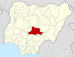
| State | Nasarawa State |
| Headquarters | Wamba |
| Government | |
| • Type | Democratic |
| • Executive Chairman | Hon. Bala Asiru |
| Time zone | UTC+1 (WAT) |
Wamba Local Government Areas of Nigeria Local Government Area is one of the 13 local government Areas in Nasarawa State, North-central Nigeria, with its headquarters situated in Wamba Town.
Contents
It has an estimated land area of 1,156 km2 and a population of about 72,894 based on the 2006 census estimates.
Wamba local government is an agrarian sub-state, it is known for casava, pidgeon pea, palm carnel and oil, productions respectively.
Wamba also has minerals deposit like lead, barite, tantalite, columbite, and gems such as Aquamarine and gold. Yet to be exploited officially.
Wamba is both heteroethnic heteroreligious, Among the nation's that make up the area are:
Arum, Atoro, Buh, Kantana, Kulere, Ninzom, Ninkada, Rindere, and Yashi.