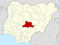
Nasarawa State

Last updated
Nasarawa
Flag of Nasarawa State.png
Seal of Nasarawa State.svg
Nicknames: 
Nigeria - Nasarawa.svg
Location of Nasarawa State in Nigeria
Coordinates: 8°32′N8°18′E / 8.533°N 8.300°E / 8.533; 8.300
Country Flag of Nigeria.svg  Nigeria
Date created 1 October 1996
Capital Lafia
Government
  BodyGovernment of Nasarawa State
   Governor [1] Abdullahi Sule (APC)
  Deputy GovernorEmmanuel Akabe (APC)
  Legislature Nasarawa State House of Assembly
   Senators N: Godiya Akwashiki (SDP)

S: Mohammed Ogoshi Onawo (PDP)

W: Ahmed Aliyu Wadada (SDP)
   Representatives List
Area
  Total26,256 km2 (10,137 sq mi)
  Rank15
Population
 (2006)
  Total1,869,377 [2]
  Estimate 
(2022-03-21)
2,886,000
  Rank30
GDP (PPP)
  Year 2021
  Total$12.01 billion [3]
30th of 36
  Per capita$4,099 [3]
17th of 36
Time zone UTC+1 (WAT)
Postal code
962101
ISO 3166 code NG-NA
HDI (2021)0.575 [4]
medium · 19th of 37
Website www.nasarawastate.gov.ng

Nasarawa State is a state in the North Central region of Nigeria, bordered to the east by the states of Taraba and Plateau, to the north by Kaduna State, to the south by the states of Benue and Kogi, and to the west by the Federal Capital Territory. Named for the historic Nasarawa Emirate, the state was formed from the west of Plateau State on 1 October 1996. [5] The state has thirteen local government areas and its capital is Lafia, located in the east of the state, while a key economic centre of the state is the Karu Urban Area—suburbs of Abuja—along the western border with the FCT. [6]

Contents

Of the 36 states of Nigeria, Nasarawa is the fifteenth largest in area and second least populous with an estimated population of about 2.5 million as of 2016. [7] Geographically, the state is mostly within the tropical Guinean forest–savanna mosaic ecoregion. Important geographic features include the River Benue forming much of Nasarawa State's southern borders and the state's far northeast containing a small part of the Jos Plateau.

Nasarawa State is inhabited by various ethnic groups, including the Koro and Yeskwa in the far northwest; the Kofyar in the far northeast; the Eggon, Gwandara, Mada, Buh, Ninzo, and Nungu in the north; the Alago, Goemai, and Megili in the east; Eloyi (Ajiri/Afo) in the south; the Tiv in the southeast; the Idoma in southwest; and the Gade and Gbagyi in the west while the Hausa and Fulani live throughout the state. Nasarawa is also religiously diverse as about 61% of the state's population are Muslims with the remaining 39% being Christian and followers of traditional ethnic religions. [8] [9]

In the pre-colonial period, the area that is now Nasarawa State was split up between various states with some states being tiny and village-based as others were part of larger empires until the early 1800s when the Fulani jihad annexed the region and placed the area under the Sokoto Caliphate as the vassal states of Keffi, Lafia, and Nassarawa. In the 1890s and 1900s, British expeditions occupied the area and incorporated it into the Northern Nigeria Protectorate. The protectorate later merged into British Nigeria in 1914 before becoming independent as Nigeria in 1960. Originally, modern-day Nasarawa State was a part of the post-independence Northern Region until 1967 when the region was split and the area became part of the Benue-Plateau State. After Benue-Plateau was split in 1976, what is now Nasarawa State became a part of the new Plateau State until 1996 when western Plateau was broken off to form the new Nasarawa State.

Economically, Nasarawa State is largely based around agriculture, mainly of sesame, soybeans, groundnut, millet, maize, and yam crops. Other key industries are services, especially in urban areas, and the livestock herding and ranching of cattle, goats, and sheep. The state has been beset by violence at various points throughout its history, most notably the ongoing conflict between herders and farmers primarily over land rights. [10] Despite the conflict, Nasarawa has the nineteenth highest Human Development Index in the country and numerous institutions of tertiary education. [11]

History

Nasarawa was established on 1 October 1996 by the Abacha government, splitting it from the today neighboring Plateau State which previously had contained both their territories. [12]

Geography

Climate

Nasarawa has a Tropical wet and dry or savanna climate. The city's yearly temperature is 29.39 °C (84.9 °F) and it is -0.07% lower than Nigeria's averages. Nasarawa typically receives about 136.71 millimeters (5.38 inches) of precipitation and has 155.37 rainy days (42.57% of the time) annually. [13]

In Nasarawa, the dry season is humid and partially cloudy, and it is hot all year long. The wet season is oppressive and overcast. The average annual temperature ranges from 63 to 95 degrees Fahrenheit, rarely falling below 57 or rising above 101. [14]

From January 29 to April 14, the hot season, with an average daily high temperature exceeding 93 °F, lasts for 2.5 months. Nasarawa's hottest month of the year is March, with an average high temperature of 95 °F and low temperature of 74 °F. [15]

The 3.7-month cool season, which runs from June 22 to October 13, has an average daily maximum temperature of less than 85 °F. Nasarawa experiences its coldest month of the year in December, with average lows of 64 °F and highs of 89 °F. [16] [17]

Boundaries

Nasarawa State is bounded to the north by Kaduna State for 169 km (105 miles), to the east by the states of Taraba for 109 km and Plateau for 219 km (136 miles), to the south by the states of Benue for 231 km, (mostly across the Benue River) and Kogi across the Benue River for 83 km, and to the west by Kogi for 68 km and the Federal Capital Territory for 156 km.

Transport

Nasarawa has a network of roads within the state, which link all rural areas and major towns.

Federal Highways are

Other major highways are

Railways:

The Nigerian Railway Corporation (NRC) operates train services with the 1067 mm Cape gauge Eastern Line north from Makurdi in Benue State via Lafia to Kafanchan in Plateau State.

Airports: Lafia Cargo Airport.

Population

Nasarawa State had a total population of 1,869,377 residents as of 2006, making the state the second least populated state in Nigeria after Bayelsa State. [18]

Air Pollution

Particulate matter, a dangerous air pollutant that can lead to bronchitis, asthma attacks, and other serious lung conditions due to chemical interactions in the environment, poses a threat to Nasarawa. [19] [20] [21] [22]

Government

The Governor of Nasarawa State is the regional executive of Nasarawa. The state legislature, Nasarawa State House of Assembly, is located in the capital of Lafia.

Local Government Areas

The State has three National Senatorial Districts, the South, North and West.

Nasarawa State consists of 13 Local Government Areas (shown with 2006 population figures [23] ):

Nasarawa West Senatorial District716,802
Karu 205,477
Keffi 92,664
Kokona 109,749
Nasarawa 189,835
Toto 119,077
Nasarawa North Senatorial District335,453
Akwanga 113,430
Eggon 149,129
Wamba 72,894
Nasarawa South Senatorial District811,020
Awe 112,574
Doma 139,607
Keana 79,253
Lafia 330,712
Obi 148,874

List of current Local Government Area Chairmen. [24]

Languages

Languages of Nasarawa State listed by LGA: [25]

LGALanguages
AkwangaMada;Eggon; Fulani; Hausa; Ninzo; Numana;
Awe Hausa; Fulani; Gwandara; Eggon; Goemai; Lijili; Tiv; Wapan
Doma Alago; Eggon; Tiv; Agatu;
keffiHausa; Fulani; : Mada GadeEggon;Gbagyi; Gwandara; Koro Wachi
KaruGbagyi; Mada; Gwandara; Gade
KeanaAlago; Gwandara Tiv; Fulani Hausa
KokonaGwandara; Mada; Afo; Eggon; Ninzo
LafiaBare-Bari; Hausa; Fulani; Ake; Mada: Alago; Agatu; Eggon; Goemai; Gwandara; Kofyar; Lijili; Tiv; Wapan
NasarawaHausa; Fulani; Mada; Agatu; Alago; Basa; Egbira; Eloyi; Gade; Gbagyi; Gwandara; Eggon; Tiv
Nasarawa-EggonEggon; Mada; Fulani; Hausa
ObiAlago; Migili; Eggon; Tiv;Gwandara
TotoEgbura Agatu; Eggon; Gade; Fulani; Mada;Hausa; Gbagyi
Wamba Alumu-Tesu;Ninzo: Mada; Rindre, Buh,; Eggon; Hausa; Fulani; Kantana; Nungu; Toro

In Nasarawa State, there are 25 different ethnic groups. The major ones are Miligi (Koro), Alago, Mada, Gwandara, Kanuri, Hausa, Fulani, Gbagyi, Rindre,Buh, Afo, Eggon and Ebira [26]

Religion

The dominant religions in Nasarawa State are Islam and Christianity, although a certain amount of traditional religion is still practised. [26] The Emir of Lafia, Sidi Dauda Bage, is the head of the Tijaniyya Sufi Order, and the 3rd highest Muslim leader in Nigeria.

About 11% Roman Catholic with 296,087 followers (2021) in the Diocese of Lafia (2000) with 15 parishes under Bishop David Ajang (2021), a suffragan of the Archdiocese of Abuja.

The Anglican Diocese of Lafia (1999) led by Bishop Godwin Adeyi Robinson (2017), is part of the Ecclesiastical Province of Abuja within the Church of Nigeria.

Economy

Concrete block factory in Nasarawa State. Concrete-block factory, Nassarawa state.jpg
Concrete block factory in Nasarawa State.

Agriculture is the mainstay of Nasarawa State's economy with the production of a variety of cash crops throughout the year. It also contains various minerals such as salt, baryte, and bauxite, which are mostly mined by artisanal miners. These mineral resources are also found in Nasarawa State: Coal, Dolomite/Marble, coal, Sapphire, Talc, Quartz, Tantalite, Tourmaline, Mica, Chalcopyrite, Clay, Cassirite, Iron-Ore, Columbite, Galena and Feldspar [27] [28]

Education

Federal Polytechnic Nasarawa, Nasarawa State, Nigeria Administrative block, FedPolyNas 2.jpg
Federal Polytechnic Nasarawa, Nasarawa State, Nigeria

The state has a College of Education in Akwanga, [29] Federal Polytechnic Nasarawa, [30] Federal College of Education (Technical) Keana, College of Agriculture in Lafia, Isa Mustapha Agwai I Polytechnic Lafia, Nasarawa State University [31] Faculty of Agriculture Lafia Campus, a newly established Federal University of Lafia, [32] Mewar International University at Masaka, Bingham University at Karu, Hill College of Education Gwanje Akwanga, NACAP polytechnic Akwanga, Command secondary school Lafia, Command secondary school Rinze, Vocational And Relevant technology board, and many primary and secondary schools including the Federal Government Girls College, Keana

Tourism

Nasarawa State is home to the Farin Ruwa Falls in Wamba Local Government area of the state. Farin Ruwa falls is one of the highest falls in Africa. [33]

The Salt Village in the Keana Local Government Area of the State produces naturally iodized salt from the lake located nearby. The town is also the cradle of Alago civilization, one of the major ethnic groups in the state. Also notable is the Eggon hills of the Eggon people which is situated around Nasarawa Eggon. This was the hills which the Eggon people had settled and established as an ancestral heritage as well. Tourists love to go hiking on this beautiful and high hill overlooking the Nasarawa Eggon local government and surrounding areas.

Another tourist site in Nasarawa State is the Maloney Hill. [34]

Keffi Town from the top of Maloney Hill Keffi Town from the top of Maloney Hill.jpg
Keffi Town from the top of Maloney Hill
Sunset on Maloney Hill Sunset on Maloney Hill.jpg
Sunset on Maloney Hill

Notable people

Related Research Articles

<span class="mw-page-title-main">Plateau State</span> State of Nigeria

Plateau State is the twelfth largest Nigerian state. It is located near the centre of Nigeria and includes a range of hills surrounding the Jos Plateau, its capital, and the entire plateau itself. Plateau State is described as "The Home of Peace and Tourism". With natural formations of rocks, hills and waterfalls, it derives its name from the Jos Plateau and has a population of around 4.7 million people.

<span class="mw-page-title-main">Lafia</span> Capital city of Nasarawa State, Nigeria

Lafia is a city in Nigeria's North Central region. It is the capital and largest city of Nasarawa State, with a population of 330,712 inhabitants as of the 2006 census.

<span class="mw-page-title-main">Abdullahi Adamu</span> Nigerian politician, Governor of Nasarawa State

Abdullahi Adamu is a Nigerian politician who was the governor of Nasarawa State in Nigeria from 29 May 1999 to 29 May 2007. He is a member and former national chairman of the ruling Party All Progressives Congress (APC).

Eggon, erroneously referred to as Mada - formerly a Plateau language spoken in central Nigeria. It is one of the major language in Nasarawa State.

Sanga is a Local Government Area in southern Kaduna State, Nigeria. Its headquarters is in the town of Gbantu. The Local Government Council is chaired by Bisallah Malam. It has an area of 1,821 km2 and had a population of 151,485 as at the 2006 census. The postal code of the area is 801.

Akwanga is a Local Government Area in Nasarawa State, Nigeria. Its headquarters are in the town of Akwanga.

<span class="mw-page-title-main">Keffi</span> LGA and Town in Nasarawa State, Nigeria

Keffi Local Government Area and also is a traditional or commercial town in Nasarawa north central Nigeria Its headquarters are in the town of Keffi. Keffi is 50 kilometers from Abuja. Nasarawa State university is located in Keffi sitting along Keffi-Akwanga express way.

<span class="mw-page-title-main">Nasarawa, Nasarawa State</span> LGA and Town in Nasarawa State, Nigeria

Nasarawa is a Local Government Area in Nasarawa State, Nigeria. Its headquarters are in the town of Nasarawa, located at 8°32'N 7°42'E, with a population of 30,949. The local government area has an area of 5,704 km2 and a population of 189,835 at the 2006 census. The postal code of the area is 962.

Doma is a Local Government Area in Nasarawa State, Nigeria. Its headquarters are in the town of Doma. Doma LGA houses Special Forces Command, Federal Science and Technical College, Olam Rice Farm and Doma Dam.

Keana is a town and Local Government Area in Nasarawa State, North Central, Nigeria. Its headquarters are in the town of Keana. It has an area of 1,048.1 km2 and a population of about 80,000. It is home to Federal Government Girls College, Keana.

<span class="mw-page-title-main">Nigerian National Assembly delegation from Nasarawa</span> Nasarawas delegation in Nigerias National Assembly

The Nigerian National Assembly delegation from Nasarawa State comprises three Senators and five Representatives.

Farin Ruwa Falls is a waterfall found in the central region of Nigeria. It is among the highest waterfalls in Nigeria. It is significant among Africa's falls when the total height covered by the waterfall is considered.

<span class="mw-page-title-main">Nasarawa State University</span> Public university in Keffi,Nasarawa

Nasarawa State University is located in Keffi Nigeria. Nassarawa State University, Keffi (NSUK), is a tertiary institution which was created to encourage the advancement of learning in the state and its neighbouring environment.

David Emmanuel Ombugadu is a Nigerian politician who was a Member of House of Representatives Nigeria representing Akwanga, Wamba and Nassarawa Eggon federal constituency from 2011 to 2019. He contested as the governorship candidate of the Peoples Democratic Party (Nigeria)(PDP) for Nasarawa state in the 2019 and 2023 general elections.

The 2023 Nasarawa State gubernatorial election will take place on 18 March 2023, to elect the Governor of Nasarawa State, concurrent with elections to the Nasarawa State House of Assembly as well as twenty-seven other gubernatorial elections and elections to all other state houses of assembly. The election—which was postponed from its original 11 March date—will be held three weeks after the presidential election and National Assembly elections. Incumbent APC Governor Abdullahi Sule is eligible to run for re-election and has been renominated by his party.

The 2019 Nigerian House of Representatives elections in Nasarawa State was held on February 23, 2019, to elect members of the House of Representatives to represent Nasarawa State, Nigeria.

The 1999 Nigerian House of Representatives elections in Nasarawa State was held on February 20, 1999, to elect members of the House of Representatives to represent Nasarawa State, Nigeria.

<span class="mw-page-title-main">2023 Nigerian Senate elections in Nasarawa State</span> 2023 Senate elections in Nasarawa

The 2023 Nigerian Senate elections in Nasarawa State will be held on 25 February 2023, to elect the 3 federal Senators from Nasarawa State, one from each of the state's three senatorial districts. The elections will coincide with the 2023 presidential election, as well as other elections to the Senate and elections to the House of Representatives; with state elections being held two weeks later. Primaries were held between 4 April and 9 June 2022.

<span class="mw-page-title-main">2023 Nigerian presidential election in Nasarawa State</span>

The 2023 Nigerian presidential election in Nasarawa State was held on 25 February 2023 as part of the nationwide 2023 Nigerian presidential election to elect the president and vice president of Nigeria. Other federal elections, including elections to the House of Representatives and the Senate, will also be held on the same date while state elections will be held two weeks afterward on 11 March.

References

  1. See List of governors of Nasarawa State for a list of prior governors
  2. "2006 PHC Priority Tables – National Population Commission". population.gov.ng. Archived from the original on 2017-10-10. Retrieved 2017-10-10.
  3. 1 2 Okeowo, Gabriel; Fatoba, Iyanuoluwa, eds. (2022-10-13). "State of States 2022 Edition" (PDF). Budgit.org. BudgIT. Retrieved 2023-03-07.
  4. "Sub-national HDI - Area Database - Global Data Lab". hdi.globaldatalab.org. Retrieved 2018-09-13.
  5. "This is how the 36 states were created". Pulse.ng. 24 October 2017. Retrieved 22 December 2021.
  6. "Nasarawa | Nasarawa State, Lafia, Akwanga | Britannica". www.britannica.com. Retrieved 2023-08-21.
  7. "Population 2006-2016". National Bureau of Statistics . Retrieved 21 December 2021.
  8. Hassan Liman, Sa’adatu; Wakawa, Abubakar Sadiq Idris (January 2012). "Muslims of Nasarawa State: A Survey" (PDF). Oxford Department of International Development . Retrieved 3 March 2022.
  9. Audu, Udege Sani (1992). The History of The Afo people (1 ed.). Kaduna: ABU printing press. p. 45.
  10. Tade, Oludayo. "What's triggered new conflict between farmers and herders in Nigeria". The Conversation . ReliefWeb . Retrieved 18 January 2022.
  11. "Human Development Indices". Global Data Lab. Retrieved 15 December 2021.
  12. Nigeria, Media (2021-12-20). "About Nasarawa State, Nigeria". Media Nigeria. Retrieved 2023-08-21.
  13. "Nasarawa, NG Climate Zone, Monthly Weather Averages and Historical Data". tcktcktck.org. Retrieved 2023-06-30.
  14. "Nasarawa Climate, Weather By Month, Average Temperature (Nigeria) - Weather Spark". weatherspark.com. Retrieved 2023-08-22.
  15. "Climate Nasarawa: Temperature, climate graph, Climate table for Nasarawa". en.climate-data.org. Retrieved 2023-08-22.
  16. "Weather in Nasarawa, Nasarawa State, Nigeria | Tomorrow.io". Tomorrow.io Weather. Retrieved 2023-08-22.
  17. "Weather Nasarawa". meteoblue. 2023-08-22. Retrieved 2023-08-22.
  18. "National Results: Population by State and Sex" (PDF). Archived from the original (PDF) on 19 May 2011. Retrieved 2022-01-08.
  19. "Air Quality & Pollen Forecast for Nasarawa". meteoblue. Retrieved 2023-09-23.
  20. "Nasarawa Air Quality Index (AQI) and Nigeria Air Pollution | IQAir". www.iqair.com. 2023-09-23. Retrieved 2023-09-23.
  21. "Nassarawa Air Quality Index (AQI) and Nigeria Air Pollution | IQAir". www.iqair.com. Retrieved 2023-09-23.
  22. "Air Quality and Pollen in Nasarawa, Nasarawa State, Nigeria | Tomorrow.io". Tomorrow.io Weather. Retrieved 2023-09-23.
  23. 2006 Population Census, Federal Republic of Nigeria, National Bureau of Statistics. Archived from the original on 2009-03-25.
  24. "List of Newly Elected Chairmen of Local Government Councils in Nasarawa State. | Official Site of Nasarawa State". Archived from the original on 2015-01-18. Retrieved 2015-01-18.
  25. "Nigeria". Ethnologue (22 ed.). Retrieved 2020-01-10.
  26. 1 2 "Nasarawa Massacre: 'Barbarians' on rampage, By Dele Agekameh | Premium Times Nigeria". 2013-05-22. Retrieved 2021-12-06.
  27. "Natural Resources – Welcome To The Embassy of Nigeria" . Retrieved 2022-03-10.
  28. Attah, Solomon (2022-03-30). "Nasarawa develops action plan to mitigate impacts of climate change, others - NUDB". Businessday NG. Retrieved 2023-08-22.
  29. Admin, I. J. N. (2020-11-03). "Full List of Courses Offered In College Of Education, Akwanga (COEAKWANGA)". ITSJAMBNEWS. Retrieved 2021-10-14.
  30. "Official List of Courses Offered in Federal polytechnic, Nasarawa (NASARAWAPOLY) - Myschool". myschool.ng. Retrieved 2021-10-14.
  31. "Official List of Courses Offered in Nasarawa State University (NSUK) - Myschool". myschool.ng. Retrieved 2021-10-14.
  32. "List Of Courses Offered at FULAFIA with Admission Requirements". www.myschoolgist.com. 2020-10-09. Retrieved 2021-10-14.
  33. Dreaming of Farin Ruwa | GlobalPost
  34. "Mission to Maloney Hill". The Nation Newspaper. The Nation. The Nation. 8 November 2012.
  35. "Ahmed Abdullahi joins Flying Eagles after Belgian club release him – Score Nigeria" . Retrieved 2023-12-26.
  36. "Abdullahi Adamu: APC National Chairman from inception and how dem take comot for office". BBC News Pidgin. 2023-07-17. Retrieved 2023-12-26.
  37. Johnson, Chris (2023-10-04). "Sen Adokwe hails tribunal ruling, tells Sule to accept Ombugadu as Nasarawa Governor". Daily Post Nigeria. Retrieved 2023-12-26.
  38. Report, Agency (2018-03-06). "Former Nasarawa gov, Aliyu Doma, dies at 75". Punch Newspapers. Retrieved 2023-12-26.
  39. Abuchi, Joe (2023-09-11). "Tribute: Life and times of Alhaji Abubakar Kana (1939 -2023)". THE AUTHORITY NEWS. Retrieved 2023-12-26.
  40. Sunday, Collins (2023-08-16). "Al-Makura's name submitted to Tinubu for ministerial slot - Nasarawa gov". Punch Newspapers. Retrieved 2023-12-26.
  41. Abujah, Racheal (2023-11-01). "WHO Lauds Ex-NPHCDA Boss For Commitment To Tackling Polio, COVID-19". Science Nigeria. Retrieved 2023-12-26.
  42. Sulaimon, Adekunle (2023-08-21). "Meet first female Minister of Police Affairs, Imaan Sulaiman-Ibrahim". Punch Newspapers. Retrieved 2023-12-26.