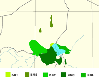
Kanuri is a dialect continuum spoken in Nigeria, Niger, Chad and Cameroon, as well as by small minorities in southern Libya and by a diaspora in Sudan.

Maiduguri is the capital and the largest city of Borno State in north-eastern Nigeria, on the continent of Africa. The city sits along the seasonal Ngadda River which disappears into the Firki swamps in the areas around Lake Chad. Maiduguri was founded in 1907 as a military outpost by the British Empire during the colonial period. As of 2022, Maiduguri is estimated to have a population of approximately two million.

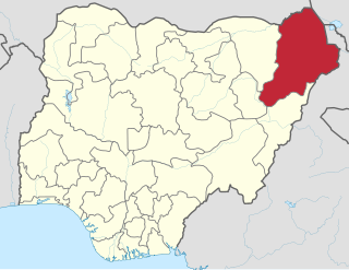
Borno State is a state in the North-East geopolitical zone of Nigeria, bordered by Yobe to the west, Gombe to the southwest for 93 km, and Adamawa to the south while its eastern border forms part of the national border with Cameroon for about 426 km, its northern border forms part of the national border with Niger, mostly across the Komadougou-Yobe River, and its northeastern border forms all of the national border with Chad for 85 km, being the only Nigerian state to border three foreign countries. It takes its name from the historic emirate of Borno, with the emirate's old capital of Maiduguri serving as the capital city of Borno State. The state was formed in 1976 when the former North-Eastern State was broken up. It originally included the area that is now Yobe State, which became a distinct state in 1991.
Damaturu is a Local Government Area and the capital city of Yobe State in northern Nigeria. It is the headquarters of the Damaturu Emirate.

Railway stations in Nigeria include:

Boko Haram, officially known as Jamā'at Ahl as-Sunnah lid-Da'wah wa'l-Jihād, is an Islamist militant organization based in northeastern Nigeria, which is also active in Chad, Niger, northern Cameroon, and Mali. Boko Haram was the world's deadliest terror group during part of the mid-2010s according to the Global Terrorism Index. In 2016, the group split, resulting in the emergence of a hostile faction known as the Islamic State's West Africa Province.
Abadam is a remote Local Government Area of Borno State, Nigeria, on the western coast of Lake Chad. It borders Chad and Niger, and it's very close to Cameroon, in 2016 its population is projected to be 140,000 inhabitants, It has its headquarters in the town of Malumfatori. Security, Healthcare, infrastructure, and climate change are some of the major challenges in Abadam Local government.
Marte is a Local Government Area of Borno State, Nigeria, on the western coast of Lake Chad. Its headquarters are in the town of Marte
Fotokol is a town and commune in Logone-et-Chari Department, Far North Region, Cameroon. It is home to Fotokol High School.

The A4 highway is a major north–south route in Nigeria that spans from the southern coast to the eastern inland region, connecting various cities and regions.

The Boko Haram insurgency began in July 2009, when the militant Islamist and jihadist rebel group Boko Haram started an armed rebellion against the government of Nigeria. The conflict is taking place within the context of long-standing issues of religious violence between Nigeria's Muslim and Christian communities, and the insurgents' ultimate aim is to establish an Islamic state in the region.
Timeline of the Boko Haram insurgency is the chronology of the Boko Haram insurgency, an ongoing armed conflict between Nigerian Islamist group Boko Haram and the Nigerian government. Boko Haram have carried out many attacks against the military, police and civilians since 2009, mostly in Nigeria. The low-intensity conflict is centred on Borno State. It peaked in the mid 2010s, when Boko Haram extended their insurgency into Cameroon, Chad and Niger.
The Konduga massacre took place in Konduga, Borno State, Nigeria on 11 February 2014. The massacre was conducted by Boko Haram Islamists against Christian villagers. At least 62 people were killed.
On the night of 5-6 May 2014, Boko Haram militants attacked the twin towns of Gamboru and Ngala in Borno State, northeastern Nigeria. About 310 residents were killed in the 12-hour massacre, and the town was largely destroyed.
Gamboru is a market town in Borno State, northeast Nigeria, near the Cameroon border. It is the administrative centre of Ngala local government area.
The Benisheik massacre was a massacre that occurred on 18 September 2013 in Benisheik, Borno State, Nigeria. Some 161 people were killed. Boko Haram took responsibility for the attacks.
The following lists events from 2014 in Nigeria.
The following lists events that happened during 2015 in Nigeria.
At about 5pm on 6 January 2020, a bomb exploded at a market in Gamboru, Borno State, northeastern Nigeria. The market is located on a bridge which connects Gamboru to Fotokol, Logone-et-Chari, Far North Region, Cameroon. The bombing killed 38 people and injured over 35 others. No group claimed responsibility. Boko Haram often carry out attacks in the region, their insurgency having caused over 35,000 deaths since it began in 2009.

The Koshebe massacre took place on 28 November 2020 in the village of Koshebe, Nigeria, in Borno State, when as many as 110 civilians and peasant farmers were killed and six were wounded as they worked in rice fields in Koshebe village, near the northeast Nigerian city of Maiduguri. The attack was thought to be carried out by the Boko Haram insurgency. About 15 women were also kidnapped.

