Yola, meaning 'Great Plain' or 'Vast Plain Land', is a large city, capital city and administrative centre of Adamawa State, Nigeria. It is located on the Benue River, and it has a population of over 336,648 (2010). Yola is split into two parts. The old town of Yola where the Lamido resides is the traditional city and the new city of Jimeta is the administrative and commercial centre. They are generally referred to as Yola.

Adamawa state is a state in the North-East geopolitical zone of Nigeria, bordered by Borno to the northwest, Gombe to the west for 95 km, and Taraba to the southwest for about 366 km, while its eastern border forms part of the national border with Cameroon across the Atlantica Mountains for about 712 km. It takes its name from the historic emirate of Adamawa, with the emirate's old capital of Yola, serving as the capital city of Adamawa state. The state is one of the most heterogeneous in Nigeria, with over 100 indigenous ethnic groups. It was formed in 1991, when the former Gongola state was divided into Adamawa and Taraba states. Since it was carved out of the old Gongola State in 1991 by the General Ibrahim Badamsi Babangida military regime, Adamawa State has had 10 men, both military and civilian, controlling the levers of power, who played crucial roles in transforming the state into what it is today.

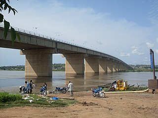
Benue River, previously known as the Chadda River or Tchadda, is the major tributary of the Niger River, with a length of approximately 1,400 kilometres (870 mi) long and almost entirely navigable during the summer months. The size of its catchment basin is 319,000 km2 (123,000 sq mi). As a result, it is an important transportation route in the regions through which it flows. The name Benue comes from Binuwe meaning 'Mother of Waters’ in the Batta language.
Taraba State is a state in North Eastern Nigeria, named after the Taraba River, which traverses the Southern part of the state. Taraba State capital is Jalingo. Its slogan is Nature's Gift to the Nation. The main ethnic groups are the Fulbe or Fulani, Mumuye, Mambilla, Jukun, Tiv, Kuteb, Wurkun, Yandang, Ndola, Itchen, Jenjo, Tigun, Jibu. The northern part is mainly dominated by the Fulbe or Fulani Mumuye, Wurkuns, Yandang, Jenjo, and Kona. The southern parts are dominated by the Jukun, Chamba, Tiv, Kuteb and Ichen.The central region is mainly occupied by Fulbe or Fulani Mambilla, Ndola, Tigun, Jibu, Wurbo and Daka peoples. There are 77 distinct ethnic groups, and their languages in the State.

Borno State is a state in the North-East geopolitical zone of Nigeria, bordered by Yobe to the west, Gombe to the southwest for 93 km, and Adamawa to the south while its eastern border forms part of the national border with Cameroon for about 426 km, its northern border forms part of the national border with Niger, for about 223 km mostly across the Komadougou-Yobe River, and its northeastern border forms all of the national border with Chad for 85 km, being the only Nigerian state to border three foreign countries. It takes its name from the historic emirate of Borno, with the emirate's old capital of Maiduguri serving as the capital city of Borno State. The state was formed in 1976 when the former North-Eastern State was broken up. It originally included the area that is now Yobe State, which became a distinct state in 1991.
Jimeta is a town in Yola, Adamawa State, Nigeria. The town's population was 73,080 in 1991. The elevation of Jimeta is 135 m, and it lies along the Benue River.

Bata (Gbwata) is an Afro-Asiatic language spoken in Nigeria in Adamawa State in the Numan, Song, Fufore and Jimeta gire Yola maiha Demsa lamorde LGAs, and in Cameroon in North Province along the border with Nigeria. Dialects are Demsa, Garoua, Jirai, Kobotachi, Malabu, Ndeewe, Ribaw, Wadi, and Zumu (Jimo). It is often considered the same language as Bacama.
Bama is a local government area of Borno State, Nigeria. It has its headquarters in the town of Bama.
The A4 highway is a major north–south route in Nigeria that spans from the southern coast to the eastern inland region, connecting various cities and regions.
The A7 Highway is a major highway in Nigeria, connecting the city of Ilorin, the capital of Kwara State, in the eastern direction to the border with Benin in the northwest. It plays a crucial role in regional transportation, passing through several cities and towns along its route.

The A8 highway is a roadway in Adamawa State, Nigeria. It spans approximately 100 kilometers, running from west to east. This highway connects two towns located to the south of the Benue River: Numan and Jimeta.
Adamawa state is the home of a large number of Christians, forming the largest minority religion in the predominantly Muslim state. Christian communities in the state have been heavily attacked by Boko Haram. However, these attacks have reduced in recent years due to the Nigerian military's efforts to combat terrorism in the region. The state has the Roman Catholic Diocese of Yola as majority headed by Stephen Dami Mamza. Ekklesiyar ‘Yan’uwar a Nigeria – has its seat in the province. Deeper Life Bible Church and Living Faith Church are present in Yola. Most of the members of the Lutheran Church of Christ in Nigeria are in the state, with the headquarters being at Numan. Fellowship Baptist Conference of Nigerian Baptist Convention has its seat at Mubi and Gongola Baptist Conference-Ag of Nigerian Baptist Convention has its seat at Numan. Gombi, Golembatal, Uvu, Nokwam Nbulum, Wurobalka and Mubi have National Evangelical Mission churches.
Timeline of the Boko Haram insurgency is the chronology of the Boko Haram insurgency, an ongoing armed conflict between Nigerian Islamist group Boko Haram and the Nigerian government. Boko Haram have carried out many attacks against the military, police and civilians since 2009, mostly in Nigeria. The low-intensity conflict is centred on Borno State. It peaked in the mid 2010s, when Boko Haram extended their insurgency into Cameroon, Chad and Niger.
The following lists events that happened during 2016 in Nigeria.
The A10 highway is a major highway in Nigeria, connecting the western and eastern regions of the country. This highway spans approximately 452 kilometers and plays a crucial role in facilitating transportation and commerce.

The A14 highway is a major highway in Nigeria that connects the city of Ilorin in the east to Bode Sadu in the west. It spans a distance of approximately 80 kilometers and plays a crucial role in the regional transportation network.
Kareto is a town located in the Mobbar Local Government Area (LGA) of Borno State, Nigeria. It is situated at coordinates 12°16′15″N13°05′32″E.

F101 is a major east–west Federal highway in Nigeria. It connects various cities and regions within Lagos State.
The 2022 Adamawa State flood was a natural disaster that occurred in Adamawa State, Nigeria, in September 2022. It affected over 30,000 square kilometers of land and exposed about 6.6 million people to potential risks. The flood was caused by heavy rainfall and increased water flows from the Cameroonian highlands. It resulted in 25 deaths, 58 injuries, and the displacement of 131,638 people. It also submerged 153 communities and damaged houses, farmlands and other properties. The flood highlighted the vulnerability of the region to such events and the need for better preparedness and mitigation measures.
