The Catholic Church in Nigeria is part of the worldwide Catholic Church, under the spiritual leadership of the Pope, the curia in Rome, and the Catholic Bishops' Conference of Nigeria (CBCN).

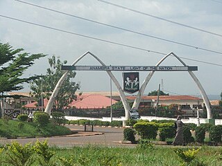
Anambra State is a Nigerian state, located in the southeastern region of the country. The state was created on 27 August 1991. Anambra state is bounded by Delta State to the west, Imo State to the south, Enugu State to the east and Kogi State to the north.

Nnewi is a commercial and industrial city in Anambra State, southeastern Nigeria. It is the second largest city in Anambra state after Onitsha. Nnewi as a metropolitan area has two local government area, which are Nnewi North and Nnewi South. Even Ekwusigo local government area is now part of Nnewi urban area, as urbanization continues to spread from Nnewi to neighbouring communities. Nnewi North comprises four quarters: Otolo, Uruagu, Umudim, and Nnewichi. The first indigenous car manufacturing plant in Nigeria is located in the city while the first wholly Made-in-Nigeria motorcycle, the 'NASENI M1' was manufactured in Nnewi.
Ihiala is a city in Nigeria, located in the southern part of Anambra State and within the region known as Igboland. It has long served as the local administrative capital of Ihiala Local Government Area. The Local Government Area has a population of about 87,796.
Ogidi is an Igbo speaking town and the headquarters of Idemili North Local Government area, Anambra State, Nigeria. It has an estimated population of 70,000 people and share boundaries with neighbouring towns like Abatete, Ṅkpọr, Ụmụnnachị, Ụmụoji, Ogbụnike and Ụmụdiọka.

Nigeria has 774 local government areas (LGAs), each administered by a local government council consisting of a chairman, who is the chief executive, and other elected members, who are referred to as councillors. Each LGA is further subdivided into a minimum of ten and a maximum of twenty wards. A ward is administered to by a councillor, who reports directly to the LGA chairman. The councillors fall under the legislative arm of the local government, the third tier of government in Nigeria, below the state governments and the federal government.

Maryland Route 650 is a state highway in the U.S. state of Maryland. Known as New Hampshire Avenue for most of its length, the state highway runs 25.89 mi (41.67 km) from Eastern Avenue at the Washington, D.C. border north to MD 108 in Etchison. MD 650 serves as a major north-south commuter route in northwestern Prince George's County and eastern Montgomery County, connecting the District of Columbia with the residential suburbs of Takoma Park, Langley Park, Adelphi, Hillandale, White Oak, and Colesville. By contrast, the part of MD 650 north of Spencerville is a quiet rural road connecting several small communities along the northeastern fringe of Montgomery County.
Sam Mbakwe International Cargo Airport, also known as Imo State Airport, serves Owerri, the capital city of Imo State in southeastern Nigeria. It is located in Ngor Okpala Local Government Area, Imo State.
Eziama Obiato is a town in Mbaitoli Local Government Area of Imo State, southeastern Nigeria. It is about 18 kilometers to the city of Owerri. The town is strategically located as it shares common boundaries with four other Local Government Areas in Imo State. It is bordered by Awo-Omamma, Umu-ofor/Akabo, Amazano/Umuaka, Afara and Umunoha. Eziama Obiato is home to the popular "Ukwuorji" Bus Stop on the Owerri/Onitsha Road.
Alor is one of the seven communities comprising the Idemili South Local Government of Anambra State in the southeast geopolitical zone of Nigeria. It is surrounded by seven neighbouring towns, namely Oraukwu, Nnobi, Abatete, Ideani, Uke, Adazi Ani and Nnokwa. Alor has several rivers which names in most cases are derived from the major idol of the village touched by the river – Mmili Ezigbo, Mmili Nwangene, Mmili Ọhọsha, Mmili Ideọhwọlọ, Mmili Iyiogwgwu, and Mmili Ọbịaja.
Rumuokoro is a town in Obio-Akpor, Rivers State, Nigeria. It is the meeting point of five major roads in Nigerian economy and the gateway to and from the city of Port Harcourt. The word, 'Rumuo' in Rumuokoro was believed to be coined by the Ikwere ethnic group of Rivers State.
Ogbaru is a local government area in Anambra State, south-central Nigeria. The area's local government headquarters is in the port city of Atani.

The A3 highway is a major arterial road in Nigeria, connecting the city of Port Harcourt in the south to the Cameroon border at Gamboru in the northeast. It is a transportation route, serving several cities and regions in Nigeria.

The A4 highway is a major north–south route in Nigeria that spans from the southern coast to the eastern inland region, connecting various cities and regions.

The A5 highway is a major highway in Nigeria. It connects the cities of Lagos, Abeokuta, and Ibadan in an eastward direction.

The A8 highway is a roadway in Adamawa State, Nigeria. It spans approximately 100 kilometers, running from west to east. This highway connects two towns located to the south of the Benue River: Numan and Jimeta.

The A13 highway is a major road in Nigeria spanning approximately 615 kilometers. It connects the city of Jimeta in Adamawa State in the south to its northern terminus near Bama in Borno State. The highway plays a significant role in regional transportation.
Joseph "Hannibal" Achuzia was a Nigerian British-trained aeronautical engineer who served as a major in the Biafran Army.

Awo-Omamma, in the Northeast of Niger Delta basin is an oil-rich indigenous Igbo town on the banks of Njaba River. It is a potential tourism hub in the region due to its species of wildlife in Umuezukwe and green vegetation.


