
U.S. Route 93 (US 93) is a major north–south 1,359-mile (2,187 km) U.S. Numbered Highway in the western United States, that connects U.S. Route 60 (US 60) in Wickenburg, Arizona, with British Columbia Highway 93 at the Canadian border. The highway passes through Kingman, Arizona; Las Vegas, Nevada; Twin Falls, Idaho; and Missoula, Montana.

A dual carriageway (BrE) or a divided highway (AmE) is a class of highway with carriageways for traffic travelling in opposite directions separated by a central reservation (BrE) or median (AmE). Roads with two or more carriageways which are designed to higher standards with controlled access are generally classed as motorways, freeways, etc., rather than dual carriageways.

The Karakoram Highway, also known as the KKH, National Highway 35, N-35, and the China–Pakistan Friendship Highway, is a 1,300 km (810 mi) national highway which extends from Hasan Abdal in the Punjab province of Pakistan to the Khunjerab Pass in Gilgit-Baltistan, where it crosses into China and becomes China National Highway 314. The highway connects the Pakistani provinces of Punjab and Khyber Pakhtunkhwa plus Gilgit-Baltistan with China's Xinjiang Uyghur Autonomous Region. The highway is a popular tourist attraction and is one of the highest paved roads in the world, passing through the Karakoram mountain range, at 36°51′00″N75°25′40″E at maximum elevation of 4,714 m (15,466 ft) near Khunjerab Pass. Due to its high elevation and the difficult conditions under which it was constructed, it is often referred to as the Eighth Wonder of the World. The highway is also a part of the Asian Highway AH4.

A diamond interchange is a common type of road junction, used where a controlled-access highway crosses a minor road.
A routenumber, designation or abbreviation is an identifying numeric designation assigned by a highway authority to a particular stretch of roadway to distinguish it from other routes and, in many cases, also to indicate its classification, general geographical location and/or orientation. The numbers chosen may be used solely for internal administrative purposes; however, in most cases they are also displayed on roadside signage and indicated on maps.

A concurrency in a road network is an instance of one physical roadway bearing two or more different route numbers. When two roadways share the same right-of-way, it is sometimes called a common section or commons. Other terminology for a concurrency includes overlap, coincidence, duplex, triplex, multiplex, dual routing or triple routing.
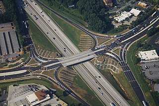
A diverging diamond interchange (DDI), also called a double crossover diamond interchange (DCD), is a subset of diamond interchange in which the opposing directions of travel on the non-freeway road cross each other on either side of the interchange so that traffic crossing the freeway on the overpass or underpass is operating on the opposite driving side from that which is customary for the jurisdiction. The crossovers may employ one-side overpasses or be at-grade and controlled by traffic lights.

In the field of road transport, an interchange or a grade-separated junction is a road junction that uses grade separations to allow for the movement of traffic between two or more roadways or highways, using a system of interconnecting roadways to permit traffic on at least one of the routes to pass through the junction without interruption from crossing traffic streams. It differs from a standard intersection, where roads cross at grade. Interchanges are almost always used when at least one road is a controlled-access highway or a limited-access divided highway (expressway), though they are sometimes used at junctions between surface streets.

A continuous flow intersection (CFI), also called a crossover displaced left-turn, is an alternative design for an at-grade road junction. Vehicles attempting to turn across the opposing direction of traffic cross before they enter the intersection. No left turn signal in the intersection is then necessary. Instead, vehicles traveling in both directions can proceed, including through vehicles and those turning right or left, when a generic traffic signal/stop sign permits.

Roads in India are an important mode of transport in India. India has a network of over 6,331,791 kilometres (3,934,393 mi) of roads. This is the second-largest road network in the world, after the United States. At of roads per square kilometre of land, the quantitative density of India's road network is equal to that of Hong Kong, and substantially higher than the United States, China, Brazil and Russia. Adjusted for its large population, India has approximately 5.13 kilometres (3.19 mi) of roads per 1,000 people, which is much lower than United States 20.5 kilometres (12.7 mi) but higher than that of China 3.6 kilometres (2.2 mi). India's road network carries over 71% of its freight and about 85% of passenger traffic.
Missouri's second congressional district is in the eastern portion of the state, primarily consisting of the suburbs south and west of St. Louis, including Arnold, Town and Country, Wildwood, Chesterfield, and Oakville. The district includes all of Franklin County and portions of St. Louis, St. Charles, and Warren counties. Following redistricting in 2010, the St. Louis Post-Dispatch reported that the district now included more Democratic-leaning voters than it had its 2001–2010 boundaries, but still leaned Republican as a whole. The latest U.S. Census Electorate Profile for the 2nd congressional district estimates there are 581,131 citizens of voting age living in 293,984 households. A primarily suburban district, MO-02 is the wealthiest of Missouri's congressional districts.
The 15th congressional district of Illinois is currently located in central Illinois. It was located in eastern and southeastern Illinois until 2022. It is currently represented by Republican Mary Miller.

State Highway 49A (SH-49A), also known as Rajiv Gandhi Salai and Rajiv Gandhi IT Expressway or just IT Expressway, is a major road connecting Chennai, Tamil Nadu state with Mahabalipuram in Chengalpattu district, in the same state. It is 45 km long and was earlier known as the Old Mahabalipuram Road (OMR). The road starts from Madhya Kailash Temple on Sardar Patel Road in South-East Chennai and terminates on East Coast Road near Mahabalipuram.

Nebraska Highway 250 (N-250) is a 48.64-mile (78.28 km) state highway in Sheridan County, Nebraska, United States, that connects Nebraska Highway 2 (N-2) in Lakeside with U.S. Route 20 (US 20) in Rushville. For its entire length, N-250 is a two-lane road located entirely within rural agricultural area.

U.S. Route 75 was a part of the United States Numbered Highway System that runs for 1,239 miles (1,994 km) from Dallas, Texas to Kittson County, Minnesota where it ends just short of the Canada–United States border. Within the State of Nebraska it is a state highway that enters Nebraska on the Kansas state line about 9 miles (14 km) south of Dawson and travels north across the extreme eastern portion of the state, to the Nebraska–Iowa border in South Sioux City where it crosses the Missouri River along a concurrency with Interstate 129. The northern 210 miles (340 km) of the route generally travels parallel to the Missouri River. The 87.32-mile (140.53 km) section between the I-680 interchange in Omaha and the Interstate 129 interchange is designated the Lewis & Clark Scenic Byway, one of nine scenic byways in the state.

The State Trunkline Highway System consists of all the state highways in Michigan, including those designated as Interstate, United States Numbered, or State Trunkline highways. In their abbreviated format, these classifications are applied to highway numbers with an I-, US, or M- prefix, respectively. The system is maintained by the Michigan Department of Transportation (MDOT) and comprises 9,669 miles (15,561 km) of trunklines in all 83 counties of the state on both the Upper and Lower peninsulas, which are linked by the Mackinac Bridge. Components of the system range in scale from 10-lane urban freeways with local-express lanes to two-lane rural undivided highways to a non-motorized highway on Mackinac Island where cars are forbidden. The longest highway is nearly 400 miles (640 km) long, while the shortest is about three-quarters of a mile. Some roads are unsigned highways, lacking signage to indicate their maintenance by MDOT; these may be remnants of highways that are still under state control whose designations were decommissioned or roadway segments left over from realignment projects.

Ortigas Avenue is a 12.1 km (7.5 mi) highway running from eastern Metro Manila to western Rizal in the Philippines. It is one of the busiest highways in Metro Manila, serving as the main thoroughfare of the metro's east–west corridor, catering mainly to the traffic to and from Rizal.
The Strade Statali, abbreviated SS, are the Italian national network of state highways. The total length of the network is about 25,000 km (16,000 mi).
Sheakhala is a village and a gram panchayat in Chanditala I community development block in Srirampore subdivision of Hooghly district in the state of West Bengal, India. It is under Chanditala police station.
