
Route 71 is a state highway in New Jersey that runs 16.7 miles (26.9 km) near the shore in Monmouth County. It begins at Route 35 in Brielle just north of the Manasquan River and the Ocean County line and heads north to Route 35 in Eatontown with a four block concurrency with Route 35 in Belmar. Monmouth University is located off Route 71 in West Long Branch.

Princes Highway is a major road in Australia, extending from Sydney via Melbourne to Adelaide through the states of New South Wales, Victoria and South Australia. It has a length of 1,941 kilometres (1,206 mi) or 1,898 kilometres (1,179 mi) via the former alignments of the highway, although these routes are slower and connections to the bypassed sections of the original route are poor in many cases.

High-Definition Multimedia Interface (HDMI) is a proprietary audio/video interface for transmitting uncompressed video data and compressed or uncompressed digital audio data from an HDMI-compliant source device, such as a display controller, to a compatible computer monitor, video projector, digital television, or digital audio device. HDMI is a digital replacement for analog video standards.

Mitchell Highway is an outback state highway located in the central and south western regions of Queensland and the northern and central western regions of New South Wales in Australia. The southern part of Mitchell Highway forms part of the National Highway A32 B71 corridor, which stretches from Sydney to Brisbane via Dubbo. Mitchell Highway also forms part of the shortest route between Sydney and Darwin, via Bourke and Mount Isa, making it an important road link for the transport of passengers and freight for regional New South Wales and Queensland. The highway is a part of route Alternative A2 between Augathella and Charleville, route A71 and B71 between Charleville and Nyngan, and part of route A32 between Nyngan and Bathurst.

The Bruce Highway is a major highway in Queensland, Australia. Commencing in the state capital, Brisbane, it passes through areas close to the eastern coast on its way to Cairns in Far North Queensland. The route is part of the Australian National Highway and also part of Highway 1, the longest highway route in Australia. Its length is approximately 1,679 kilometres (1,043 mi); it is entirely sealed with bitumen. The highway is named after a popular former Queensland and federal politician, Harry Bruce. Bruce was the state Minister for Works in the mid-1930s when the highway was named after him. The highway once passed through Brisbane, but was truncated at Bald Hills when the Gateway Motorway became National Highway 1 upon its opening in December 1986.

A cloverleaf interchange is a two-level interchange in which all turns are handled by slip roads. To go left, vehicles first continue as one road passes over or under the other, then exit right onto a one-way three-fourths loop ramp (270°) and merge onto the intersecting road. The objective of a cloverleaf is to allow two highways to cross without the need for any traffic to be stopped by traffic lights. The limiting factor in the capacity of a cloverleaf interchange is traffic weaving.
A routenumber, designation or abbreviation is an identifying numeric designation assigned by a highway authority to a particular stretch of roadway to distinguish it from other routes and, in many cases, also to indicate its classification, general geographical location and/or orientation. The numbers chosen may be used solely for internal administrative purposes; however, in most cases they are also displayed on roadside signage and indicated on maps.

A concurrency in a road network is an instance of one physical roadway bearing two or more different route numbers. When two roadways share the same right-of-way, it is sometimes called a common section or commons. Other terminology for a concurrency includes overlap, coincidence, duplex, triplex, multiplex, dual routing or triple routing.
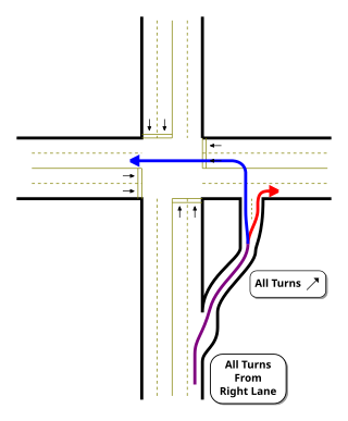
A jughandle is a type of ramp or slip road that changes the way traffic turns left at an at-grade intersection. Instead of a standard left turn being made from the left lane, left-turning traffic uses a ramp on the right side of the road. In a standard forward jughandle or near-side jughandle, the ramp leaves before the intersection, and left-turning traffic turns left off of it rather than the through road; right turns are also made using the jughandle. In a reverse jughandle or far-side jughandle, the ramp leaves after the intersection, and left-turning traffic loops around to the right and merges with the crossroad before the intersection.

State Highway 7 (SH 7) is an east–west state highway in the U.S. state of Texas that runs from Interstate 35 at Eddy to U.S. Highway 84 about 3 miles (4.8 km) west of the Louisiana state line. Between Crockett and Nacogdoches, SH 7 passes through the Davy Crockett National Forest. Commissioned on April 4, 1917, SH 7 is one of the original state highways established in Texas, and has been re-routed several times since its original conception. In earlier years, SH 7 mostly followed present day U.S. Highway 84, U.S. Highway 67, U.S. Highway 70 among other highways between northwest Texas and the Louisiana state line. By 1939, most of the mileage belonging to SH 7 was transferred to the U.S. Highway System, leaving the highway extant only within eastern Texas. SH 7 subsequently went through several other major reroutings, truncations and extensions between 1939 and 1990, before becoming the highway it is today.

DisplayPort (DP) is a proprietary digital display interface developed by a consortium of PC and chip manufacturers and standardized by the Video Electronics Standards Association (VESA). It is primarily used to connect a video source to a display device such as a computer monitor. It can also carry audio, USB, and other forms of data.
In many countries, kilometre zero or similar terms in other languages denote a particular location from which distances are traditionally measured and some use this as their official country location or coordinates for faster search at space satellites, this is also used for measuring distances between different countries around the world. Historically, they were markers where drivers could set their odometers to follow the directions in early roaming guide books.
Central Coast Highway is a 50-kilometre (31 mi) highway through the Central Coast region of New South Wales, Australia. It connects Pacific Motorway (M1) at Kariong with Pacific Highway (A43) at Doyalson. The highway was named after the region it goes through, to provide an easily identifiable route for visitors to the region, and is designated route A49.
The 15th congressional district of Illinois is currently located in central Illinois. It was located in eastern and southeastern Illinois until 2022. It is currently represented by Republican Mary Miller.

The A237 highway is a highway in Nigeria. It is one of the East-West roads linking the main south-north roads..

The A123 highway is a highway in Nigeria. It is one of the east-west roads linking the main south-north roads.(It is named from the two highways it links).
The Strade Statali, abbreviated SS, are the Italian national network of state highways. The total length of the network is about 25,000 km (16,000 mi).

Gazi Mustafa Kemal Boulevard, abbreviated as GMK Boulevard, is a major avenue in Mersin, Turkey. It is named after Mustafa Kemal Atatürk (1881-1938), the founder of Turkish Republic.
Sheakhala is a village and a gram panchayat in Chanditala I community development block in Srirampore subdivision of Hooghly district in the state of West Bengal, India. It is under Chanditala police station.
