
Maiduguri is the capital and the largest city of Borno State in north-eastern Nigeria, on the continent of Africa. The city sits along the seasonal Ngadda River which disappears into the Firki swamps in the areas around Lake Chad. Maiduguri was founded in 1907 as a military outpost by the British Empire during the colonial period. As of 2022, Maiduguri is estimated to have a population of approximately two million people, in the metropolitan area.

Yobe is a state located in northeastern Nigeria. A mainly agricultural state, it was created on 27 August 1991. Yobe State was carved out of Borno State. The capital of Yobe State is Damaturu, and its largest city by population is Potiskum, while the largest by land area is Fune. The Potiskum local government area is a place of farmers and marketers; the largest cattle market in Africa is located in Potiskum.

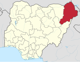
Borno is a state in the North-East geopolitical zone of Nigeria. It is bordered by Yobe to the west for about 421 km, Gombe to the southwest for 93 km, and Adamawa to the south while its eastern border forms part of the national border with Cameroon for about 426 km. Its northern border forms part of the national border with Niger for about 223 km, mostly across the Komadougou-Yobe River, and its northeastern border forms all of the national border with Chad for 85 km. It is the only Nigerian state to border up to three countries. It takes its name from the historic emirate of Borno, with the emirate's old capital of Maiduguri serving as the capital city of Borno State. The state was formed in 1976 when the former North-Eastern State was broken up. It originally included the area that is now Yobe State, which became a distinct state in 1991.
Bokkos is a Local Government Area in Plateau State, Nigeria. Its headquarters are in the town of Bokkos at 9°18′00″N9°00′00″E.

Madagali or Madagli is a town and local government area in Adamawa State, Nigeria, adjacent to the border with Cameroon.
Konduga is a community in Borno State, Nigeria and the center of a Local Government Area of the same name about 25 km to the southeast of Maiduguri, situated on the north bank of the Ngadda River. The population of the Konduga Local Government Area is about 13,400. It is one of the sixteen LGAs that constitute the Borno Emirate, a traditional state located in Borno State, Nigeria. The primary languages are Shuwa Arabic, Kanuri, Mafa and Wandala / Malgwa.
Marte is a Local Government Area of Borno State, Nigeria, on the western coast of Lake Chad. Its headquarters are in the town of Marte

Askira/Uba is a Local Government Area of Borno State, Nigeria. Its headquarters are in the town of Askira.
Gubio, also Gobiyo, is a Local Government Area of Borno State, in northeastern Nigeria. Its headquarters are in the town of Gubio.

Gwoza is a local government area of Borno State, Nigeria. Its headquarters are in the town of Gwoza, a border town "about 135 kilometres South-East of Maiduguri." The postal code of the area is 610.
Monguno is one of the local government areas of Borno State, in northeastern Nigeria.

Potiskum is a local government area and city in Yobe State northeastern part of Nigeria. It's the largest, most populous and fastest growing city in Yobe State. Of the native languages in Yobe State, Potiskum is home to several major groups which include the Karai-Karai, Bolewa and Ngizim and Hausa-Fulani. It is on the A3 highway at 11°43′N11°04′E. It has an area of 559 square kilometres (216 sq mi).

Geidam is a Local Government Area in Yobe State, Nigeria. Its headquarters are in the town of Geidam in the northwest of the area at 12°53′49″N11°55′49″E. On 24 April 2021 terrorists from ISWAP seized Geidam killing 11 people, and over 6,000 residents were displaced. However, the Nigerian Armed Forces retook the town after an offensive against the terrorists.

The Boko Haram insurgency began in July 2009, when the militant Islamist and jihadist rebel group Boko Haram started an armed rebellion against the government of Nigeria. The conflict is taking place within the context of long-standing issues of religious violence between Nigeria's Muslim and Christian communities, and the insurgents' ultimate aim is to establish an Islamic state in the region.
On 29 September 2013, gunmen from Boko Haram entered the male dormitory in the College of Agriculture in Gujba, Yobe State, Nigeria, killing forty-four students and teachers.
Timeline of the Boko Haram insurgency is the chronology of the Boko Haram insurgency, an ongoing armed conflict between Nigerian Islamist group Boko Haram and the Nigerian government. Boko Haram have carried out many attacks against the military, police and civilians since 2009, mostly in Nigeria. The low-intensity conflict is centred on Borno State. It peaked in the mid-2010s, when Boko Haram extended their insurgency into Cameroon, Chad and Niger.
Gamboru is a market town in Borno State, northeast Nigeria, near the Cameroon border. It is the administrative centre of Ngala local government area.
The following lists events from 2014 in Nigeria.
The following lists events that happened during 2015 in Nigeria.
On 25 April 2021, a large group of ISWAP insurgents killed 33 soldiers in Mainok, a town 36 miles west of Maiduguri in Borno State, Nigeria.


