Yobe | |
|---|---|
 Flag  Seal | |
| Nicknames: | |
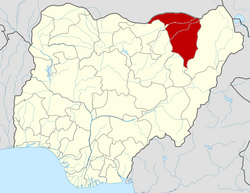 Location of Yobe State in Nigeria | |
| Coordinates: 12°00′N11°30′E / 12.000°N 11.500°E | |
| Country | |
| Date created | 27 August 1991 |
| Capital | Damaturu |
| Government | |
| • Body | Government of Yobe State |
| • Governor (List) | Mai Mala Buni (APC) |
| • Deputy Governor | Idi Barde Gubana (APC) |
| • Legislature | Yobe State House of Assembly |
| • Senators | C: Ibrahim Gaidam (APC) N: Ahmed Lawan (APC) S: Ibrahim Mohammed Bomai (APC) |
| • Representatives | List |
| Area | |
• Total | 45,502 km2 (17,568 sq mi) |
| • Rank | 6th of 36 |
| Population (2006 census) | |
• Total | 2,321,339 [1] |
• Estimate (2021) | 4,000,000 |
| • Rank | 32nd of 36 |
| • Density | 51.016/km2 (132.13/sq mi) |
| GDP (PPP) | |
| • Year | 2023 |
| • Total | $8.3 billion [2] |
| • Per capita | $2,190 [2] |
| Time zone | UTC+01 (WAT) |
| postal code | 620001 |
| Area code | +234 |
| ISO 3166 code | NG-YO |
| HDI (2018) | 0.365 [3] low · 35th of 37 |
Yobe was created on 27 August 1991. It is a mainly agricultural state, and it is a state located in northeastern Nigeria. [4] Yobe State was carved out of Borno State. The capital of Yobe State is Damaturu; its largest and most populated city is Potiskum.