| Part of a series on |
|---|
 |
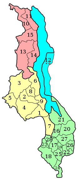
Malawi is divided into 28 districts [1] within three regions. Each District is headed by a District Commissioner: [2]
Contents
| Region | Name | Population (2018 [3] ) | Total Area (km2) | Capital | Index |
|---|---|---|---|---|---|
| Central | Dedza | 830,512 | 3,754 | Dedza | 1 |
| Dowa | 772,569 | 3,077 | Dowa | 2 | |
| Kasungu | 842,953 | 8,017 | Kasungu | 3 | |
| Lilongwe | 2,626,901 | 6,211 | Lilongwe | 4 | |
| Mchinji | 602,305 | 3,131 | Mchinji | 5 | |
| Nkhotakota | 393,077 | 4,338 | Nkhotakota | 6 | |
| Ntcheu | 659,608 | 3,251 | Ntcheu | 7 | |
| Ntchisi | 317,069 | 1,709 | Ntchisi | 8 | |
| Salima | 478,346 | 2,151 | Salima | 9 | |
| Northern | Chitipa | 234,927 | 4,334 | Chitipa | 10 |
| Karonga | 365,028 | 3,416 | Karonga | 11 | |
| Likoma | 14,527 | 20 | Likoma | 12 | |
| Mzimba | 1,161,456 | 10,473 | Mzimba | 13 | |
| Nkhata Bay | 284,681 | 4,182 | Nkhata Bay | 14 | |
| Rumphi | 229,161 | 4,560 | Rumphi | 15 | |
| Southern | Balaka | 438,379 | 2,142 | Balaka | 16 |
| Blantyre | 1,251,484 | 2,025 | Blantyre | 17 | |
| Chikwawa | 564,684 | 4,878 | Chikwawa | 18 | |
| Chiradzulu | 356,875 | 761 | Chiradzulu | 19 | |
| Machinga | 735,438 | 3,582 | Machinga | 20 | |
| Mangochi | 1,148,611 | 6,729 | Mangochi | 21 | |
| Mulanje | 684,107 | 2,005 | Mulanje | 22 | |
| Mwanza | 130,949 | 756 | Mwanza | 23 | |
| Nsanje | 299,168 | 1,945 | Nsanje | 24 | |
| Thyolo | 721,456 | 1,666 | Thyolo | 25 | |
| Phalombe | 429,450 | 1,323 | Phalombe | 26 | |
| Zomba | 851,737 | 2,405 | Zomba | 27 | |
| Neno | 138,291 | 1,561 | Neno | 28 |