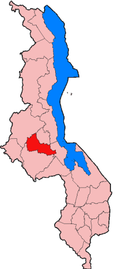
Dowa is a district in the Central Region of Malawi. The capital is Dowa.
Contents
- Geography
- Main cities
- Demographics
- Culture
- Economy
- Education
- Government and administrative divisions
- Climate
- References
Dowa is a district in the Central Region of Malawi. The capital is Dowa.
The district covers an area of 3,041 km². and has a population of 556, 678. The capital city, Dowa is home to 5,565 people. Dowa the city is about 38 kilometers away from Malawi's capital city, Lilongwe. [1] The population is projected to reach over 700,000 by 2018. [2]
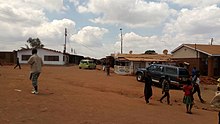
(MVERA roadblock)
At the time of the 2018 Census of Malawi, the distribution of the population of Dowa District by ethnic group was as follows: [3]
The Chewas are the main ethnic group, and second are the Ngonis. Nyau dancing is an integral part of the culture inherited from the Chewa ancestors. These two groups are mostly farming communities. People of the Yao ethnic group are also found, mostly in trading centers. [4]
Dowa District is an agricultural district which focuses on cotton, tobacco and groundnut farming, and the main food crops produced in the district are maize, sweet potatoes, tomatoes and pulses. [5]
Dowa TTC College opened in 2003. [6] The district aims to drop the high school dropout rate from six percent to four percent by 2020, and also add more classrooms to lower the current 111 to 1 student/classroom ratio. [7]
There are seven National Assembly constituencies in Dowa:
Since the 2009 election all of the areas have been controlled by members of the Malawi Congress Party. [8]
Dowa District is in the humid subtropical climate zone, and the mean temperature is about 65 degrees Fahrenheit. There are as many as twenty rainy days a month in the wet season to as little as none in the dry season. [9]
Zomba is a city in southern Malawi, in the Shire Highlands. It is the former capital city of Malawi.

The Central Region of Malawi, population 7,523,340 (2018), covers an area of 35,592 km2. Its capital city is Lilongwe, which is also the national capital. The region has an outlet on Lake Malawi and borders neighbouring countries Zambia and Mozambique. The Chewa people make up the majority of the population today.
Balaka is a district in the Southern Region of Malawi. The capital is Balaka. The district covers an area of 2,140 km.² and has a population of 438,379. The district's population is increasing at a rate of 2.3% per annum. Major attractions in Balaka District include the 1,850 Ha estate Toleza Agricultural Enterprises, St. Louis Montfort Catholic Church, the Andiamo Vocational Complex and the Chifundo Artisans' Network.
Blantyre is a district in the Southern Region of Malawi. The capital is Blantyre, a commercial city where most Malawian industrial and business offices are. The district covers an area of 2,012 km² and has a population of 809,397. It was named after Blantyre, the birth village of David Livingstone in Scotland, one of the first missionary explorers who came to Nyasaland, as Malawi was called before independence in 1964. It is also a main trading point besides the other large cities in Malawi. The other large cities are Lilongwe, which is located in the central region, and Mzuzu, which is in the northern part of Malawi.
Chikwawa is a district in the Southern Region of Malawi. The capital is Chikwawa. The district covers an area of 4,755 km² and has a population of 356,682.
Chiradzulu is a district in the Southern Region of Malawi. The capital is Chiradzulu. The district covers an area of 761 km.² and has a population of 356,875
Dedza is a district in the Central Region of Malawi. It covers an area of 3,754 km.² to the south of the Malawi capital, Lilongwe, between Mozambique and Lake Malawi and has a population of 830,512. The capital is Dedza.
Karonga is a district in the Northern Region of Malawi. The district covers an area of 3,355 km.² and has a population of 365,028. It is a border district between Malawi and Tanzania's Mbeya Region's Kyela District and is mainly occupied by the Tumbuka and Nkhonde tribes. Other tribes include Henga tribe.
Kasungu is a district in the Central Region of Malawi. The capital is Kasungu. The district covers an area of 7,878 km², borders Zambia and has a population of 842,953.
Lilongwe is a district in the Central Region of Malawi. The capital is Lilongwe.
Likoma District is the smallest in size and the least populous district of Malawi, which consists of two separate exclaves of Malawi situated within Mozambican waters in Lake Malawi. It consists of two main islands, Likoma and Chizumulu. It is a district in the Northern Region of Malawi. The capital is Likoma. The district covers an area of 20 km², and has a population of 14,527.

Machinga is a district in the Southern Region of Malawi. The capital is Machinga. The district covers an area of 3,771 km.² and has a population of 369,614.
Mchinji is a district in the Central Region of Malawi. The capital is Mchinji. The district covers an area of 3,356 km2 (1,296 sq mi) and has a population of 602,305. The area's economy is sustained by rain-fed agriculture.
Mulanje is a district in the Southern Region of Malawi. Its capital is Mulanje. The district covers an area of 2,056 km.² and has a population of 428,322. It is also known for its tea-growing industry and Mount Mulanje, one of the highest peaks in Southern Africa.
Mwanza is a district in the Southern Region of Malawi. The capital is Mwanza. The district covers an area of 2,259 km² and has a population of 138,015.

Ntcheu is a district in the Central Region of Malawi. It borders with the country of Mozambique. The district headquarters is Ntcheu, known as BOMA in the local language, but is most commonly called Mphate. It is run by Yeneya, the village headman. The district covers an area of 3,424 km.² and has a population of 659,608 people according to the 2018 Malawi Population and Housing Census. The Ntcheu district lies around halfway between Malawi's majors cities of Blantyre and Lilongwe - the capital city.
Nkhata Bay is a district in the Northern Region of Malawi. The capital is Nkhata Bay. The district covers an area of 4,071 km.² and has a population of 164,761.
Nkhotakota is a district in the Central Region of Malawi. The capital is Nkhotakota. The district covers an area of 4,259 km² and has a population of 395,897. The word Nkhotakota means "zig-zag" in Chichewa. It is located along the shore of Lake Malawi.
Ntchisi is a district in the Central Region of Malawi. The district covers an area of 1,655 km.² and has a population of 317,069. The capital is Ntchisi.
Salima is a district in the Central Region of Malawi. The city of Salima is the district's capital. The district covers an area of 2,196 km.² and has a population of 478,346. The beach at Senga Bay is the weekend retreat of many from the capital, Lilongwe, and has hosted the annual Lake of Stars festival since 2008, when it was moved from Chintheche in order to be less remote. There is a range of accommodation options in the area, though most are a few kilometers off the main road.
13°35′S34°00′E / 13.583°S 34.000°E
| Authority control databases: Geographic |
|---|
| | This Malawi location article is a stub. You can help Wikipedia by expanding it. |