Ghanzi

Last updated
Ghanzi
Town
GantsiHighStreet.jpg
A view of a Ghanzi street
Botswana location map.svg
Red pog.svg
Ghanzi
Location in Botswana
Coordinates: 21°42′S21°49′E / 21.700°S 21.817°E / -21.700; 21.817
Country Flag of Botswana.svg Botswana
District Ghanzi District
Area
  Land1,800 km2 (690 sq mi)
Elevation
1,420 m (4,660 ft)
Population
 (2021)
  Total21,420
Climate BSh

Ghanzi is a town in the middle of the Kalahari Desert the western part of the Republic of Botswana in southern Africa. The region is the country's pride in contributing a large portion towards the beef industry. In fact, Ghanzi farmers provide about 75% percent of beef exports, according to the Botswana Meat Commission, primarily to the United Kingdom and the European Union. [1]

Contents

At the time of the 2021 census, there are 21,420 people living in the town with another 6,900 nearby. [2] Ghanzi is the administrative center of Ghanzi District and is considered the "capital" of the district, as it is the largest in terms of population and geographical measure. [3] Ghanzi District measures 117,910 square kilometres (29,140,000 acres) and is bordered by Ngamiland to the north, Central District to the east, and Kgalagadi and Kweneg Districts to the south. Its western border is shared with Namibia.

Location of Ghanzi in Botswana BW-Ghanzi.png
Location of Ghanzi in Botswana

Name

Other spellings of Ghanzi include "Gantsi" - which is more consistent with Setswana, the national language of Botswana - "Ghansi"; and "Ghantsi". It has also been purported[ citation needed ] that the various renderings of Ghanzi actually stem from the Naro language word "Gaentsii", meaning "gigantic swollen buttocks", referring to the body part of an antelope, and later cattle that congregated around a pan in the area.

History

The first Afrikaner to settle in Ghanzi was the flamboyant Hendrik van Zyl, who crossed the Kalahari and set up a small hunting and trading enterprise in the area around 1870 and gained extravagant wealth in the ivory trade. However, the first substantial Boer migration into Ghanzi began around 1897–1898.

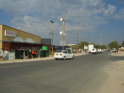
The place known today as Ghanzi was first called "Kamp". The Kalahari Arms Hotel and the Barclays bank in Ghanzi were some of the first businesses established in Ghanzi.

The town of Ghanzi was the subject of a 1988 LA Times article which described the close-knit relationship between resident Afrikaners and Bushmen. At the time, there was no radio or television in Ghanzi, and the Kalahari Arms Hotel, which was surrounded by a 9 foot high fence to keep lions out, hosted the only bar and discotheque in the area. [4]

Residents

Ghanzi is a place of different ethnic groups such as Afrikaners, Basarwa, Bakgalagadi and Baherero, who all have a spirit of tolerance. Residents of this place speak different languages such as Afrikaans, English, Sesarwa, Setswana, Sekgalagadi and Seherero, but their standard language is Shekgalagari and Naro. Though there is no available information as to the current numbers of the Afrikaner population, in 1973, Kalahari Boer made up about 10% of the population in Ghanzi. [5]

Geology and climate

The district's land surface mainly consists of gently undulating sandveld which lies between 1,100 and 1,230 meters above sea level. The Kalahari is the largest continuous stretch of sand in the world, covering some 2,500 km2. Karoo sediments, covered by younger basaltic lavas, underlie most of the Kalahari sands and about half of the country of Botswana. The sands of the Kalahari vary in depth from 5m to 200m.

The climate is semi-arid. Mean maximum daily temperatures are 33-45 °C in January and around 22 °C in July; mean minimum temperatures are 4 to -5 °C in the winter months. The long-term mean annual rainfall is around 375mm although this can vary by up to 50% year by year. Generally speaking, both the climate and the soils are unfavorable for arable farming. Small cultivation is spread over the district but is limited to subsistence crops of maize, sorghum, beans, peas, and melons. [6] The record high temperature ever registered in Ghanzi was 42.2 °C (108.0 °F). [7] The lowest temperature registered in Ghanzi was −8.5 °C (16.7 °F). [7]

Commercial developments

Ghanzi has three banksBarclays Bank, First National Bank, and Bank Gaborone, all of which have ATMs. Ghanzi now has three shopping centres: Ghanzi Spar, Shoprite and the recently opened Choppies, another retailer in Botswana.

Ghanzi Airport serves the town. There is currently no scheduled service, only charter and private operations.

Tourism and events

Ghanzi is well known countrywide for its annual agricultural show usually held in August each year. The show was first held in 1974 with initial aim to exhibit livestock breeds, for the longest time livestock breeds exhibition has dominated part of the activities of the show. However, in recent years crop production exhibition has gained a spot in the show as way of diversifying activities of the show and the agricultural aspect of the region. [8] Stakeholders and government departments like Local Enterprise Authority also exhibits at the show. [9] Actions are also held at the premises and BDF (Botswana Defense Force) usually comes to show their weaponry.

Ghanzi is a stop over point for travellers wishing to visit the Okavango Delta; there are many lodges in the area and three filling stations. It is the only available fill-up point between Kang and Maun, which is about 500 km, if one are travelling to the Okavango Delta. There is one hotel in Ghanzi town, the Kalahari Arms Hotel which offers accommodation and has a restaurant and bar open to non-residents. Tau Tona Lodge is another hotel approximately 5 km from the centre of town it also has accommodation and a restaurant and bar open to non-residents. Less formal accommodation, food and drink is available at Thakadu Camp about 6 km from the centre of town. There are other B&Bs and lodges scattered throughout the town.

There are some interesting things to see in Ghanzi. Kuru, which is a charity assisting the San / Bushmen has a small shop selling hand made Bushmen crafts. There are few sightseeing spots in Ghanzi - lions are kept in enclosures at the main gate of TauTona. "Ghanzi gat" is a hole that was made while the tar road was being made in Ghanzi, but while using dynamite to break the rock open, the people accidentally opened a water vein. This filled the 40m deep hole with water.

Agriculture

Ghanzi is primarily dominant in cattle farming industry in Botswana. Today the town features a thriving Afrikaner cattle ranching industry. [10]

Mining

A large copper-silver deposit is being outlined at Ghanzi by Hana Mining. [11]

Timeline

Related Research Articles

<span class="mw-page-title-main">Botswana</span> Country in Southern Africa

Botswana, officially the Republic of Botswana, is a landlocked country in Southern Africa. Botswana is topographically flat, with approximately 70 per cent of its territory being the Kalahari Desert. It is bordered by South Africa to the south and southeast, Namibia to the west and north, and Zimbabwe to the northeast. It is connected by the Kazungula Bridge to Zambia, across the world's shortest border between two countries.

<span class="mw-page-title-main">Geography of Botswana</span>

Botswana is a landlocked country located in Southern Africa, north of South Africa. Botswana occupies an area of 581,730 square kilometres (224,610 sq mi), of which 566,730 km2 (218,820 sq mi) are land. Botswana has land boundaries of combined length 4,347.15 kilometres (2,701.19 mi), of which the constituent boundaries are shared with Namibia, for 1,544 km (959 mi); South Africa 1,969 km (1,223 mi); Zimbabwe, 834 km (518 mi) and Zambia, 0.15 km (0.093 mi). Much of the population of Botswana is concentrated in the eastern part of the country.

<span class="mw-page-title-main">Kalahari Desert</span> Semi-arid sandy savanna in Southern Africa

The Kalahari Desert is a large semi-arid sandy savanna in Southern Africa extending for 900,000 square kilometres (350,000 sq mi), covering much of Botswana, as well as parts of Namibia and South Africa.

<span class="mw-page-title-main">Gaborone</span> Capital and the largest city of Botswana

Gaborone is the capital and largest city of Botswana with a population of 246,325 based on the 2022 census, about 10% of the total population of Botswana. Its agglomeration is home to 421,907 inhabitants at the 2011 census.

<span class="mw-page-title-main">Tswana people</span> Bantu ethnic group in Southern Africa

The Tswana are a Sotho-Tswana ethnic group native to Southern Africa. Ethnic Tswana made up approximately 85% of the population of Botswana in 2011.

<span class="mw-page-title-main">San people</span> Members of various indigenous hunter-gatherer people of Southern Africa

The San peoples, or Bushmen, are the members of the indigenous hunter-gatherer cultures of southern Africa, and the oldest surviving cultures of the region. Their ancestral territories span Botswana, Namibia, Angola, Zambia, Zimbabwe, Lesotho and South Africa. They speak, or their ancestors spoke, languages of the Khoe, Tuu and Kxʼa language families, and are only a 'people' in contrast to pastoralists such as the Khoekhoe and descendants of more recent waves of immigration such as the Bantu, Europeans and Asians.

<span class="mw-page-title-main">Okavango Delta</span> River delta in Botswana

The Okavango Delta in Botswana is a vast inland delta formed where the Okavango River reaches a tectonic trough at an altitude of 930–1,000 m in the central part of the endorheic basin of the Kalahari. It is an UNESCO World Heritage Site as one of the few interior delta systems that do not flow into a sea or ocean, with a wetland system that is largely intact. All the water reaching the delta is ultimately evaporated and transpired. Each year, about 11 cubic kilometres (2.6 cu mi) of water spreads over the 6,000–15,000 km2 (2,300–5,800 sq mi) area. Some flood waters drain into Lake Ngami. The area was once part of Lake Makgadikgadi, an ancient lake that had mostly dried up by the early Holocene.

<span class="mw-page-title-main">Maun, Botswana</span> Place in North-West District, Botswana

Maun is the fifth-largest town in Botswana. As of 2011, it had a population of 55,784. Maun is the "tourism capital" of Botswana and the administrative centre of Ngamiland district. Francistown and Maun are linked by the A3 highway. It is also the headquarters of numerous safari and air-charter operations who run trips into the Okavango Delta.

<span class="mw-page-title-main">Kang, Botswana</span> Village in Kgalagadi District of Botswana

Kang is a village in Kgalagadi District of Botswana. It is situated in the Kalahari Desert and lies on the Trans-Kalahari Highway between Ghanzi in the north and Sekoma in the south. Kang also provides access to the Kgalagadi Transfrontier Park in the south-west and the Central Kalahari Game Reserve in the north-east. The route via Ghanzi takes one to the Namibian border, whilst that to Sekoma leads to Gaborone, the capital of Botswana. The population was 5,985 according to the 2011 census. Kang also falls under the Kgalagadi North constituency whose Member of Parliament is Hon. Talita Monnakgotla. The village is divided into seven wards which are; Gasekgalo, Gamonyemana, Gamotshoto, Gapanyana, Gamoriti, Kaatshwene and Tshwaragano ward. The village is led by a female chief, Kgosi Basadi Seipone who is the daughter to the late former chief Churchill Pego Seipone who died in 2010. The village's key development areas include the Central Roads Depot, Central Transport Organisation, Airstrip/Landing ground, mini Rural Administration Centre/ Service Centre, Botswana Open University Regional Campus, Brigade Centre, Police Station, Health Clinic, Magistrate Court, Department Road Transport Service offices, Wildlife offices, Botswana Power Corporation Offices, Water Utilities Corporation offices, Facility Management offices, Senior Secondary, Junior Secondary School and two primary schools.

Debswana Diamond Company Limited, or simply Debswana, is a mining company located in Botswana, and is the world's leading producer of diamonds by value. Debswana operates four diamond mines in the eastern and central parts of Botswana, as well as a coal mine. Debswana is a joint venture between the government of Botswana and the South African diamond company De Beers; each party owns 50 percent of the company.

<span class="mw-page-title-main">North-West District (Botswana)</span> District in Botswana

The North-West District or Ngamiland is one of the first-level administrative subdivisions of Botswana. For census and administrative purposes Ngamiland is subdivided into Ngamiland East, Ngamiland West and Ngamiland Delta (Okavango). It is governed by a District Commissioner, appointed by the national government, and the elected North-West District Council. The administrative centre is Maun.

Mahalapye is a town located in the Central District of Botswana. The town has about 41,000 inhabitants and is situated along the main road between the capital Gaborone and the second largest city Francistown. Mahalapye has a bus station, a railway station, a couple of hotels and a market area with many shops and fast food restaurants, Water Shed mall is the latest attraction to those travelling from Gaborone to Francistown, great place for refreshments. It also has several petrol stations, some open 24 hours per day. Being situated on the edge of the Kalahari desert it is quite dry, and the local waterways are dry except during the rainy season. In recent times, it has become a convenient stop-over town for travelers travelling to and from Gaborone.

<span class="mw-page-title-main">Tsabong</span> Place in Kgalagadi District, Botswana

Tsabong, also spelled Tshabong, is the administrative centre of the Kgalagadi District in Botswana. It is located in the Kalahari Desert. The population was 8939 in the 2011 census.

<span class="mw-page-title-main">Culture of Botswana</span> Overview of the culture of Botswana

Besides referring to the language of the dominant people groups in Botswana, Setswana is the adjective used to describe the rich cultural traditions of the Batswana - whether construed as members of the Setswana ethnic groups or of all citizens of Botswana. the Batswana believe in the rich culture of Botho-Ubuntu, ‘‘People are not individuals, living in a state of independence, but part of a community, living in relationships and interdependence.’ Batswana believe in working together and in being united.

<span class="mw-page-title-main">Wildlife of Botswana</span> Flora and fauna of Botswana

The wildlife of Botswana refers to the flora and fauna of this country. Botswana is around 90% covered in savanna, varying from shrub savanna in the southwest in the dry areas to tree savanna consisting of trees and grass in the wetter areas. Even under the hot conditions of the Kalahari Desert, many species survive; in fact the country has more than 2500 species of plants and 650 species of trees. Vegetation and its wild fruits are also extremely important to rural populations living in the desert and are the principal source of food, fuel and medicine for many inhabitants.

New Xade is a village located in the central part of the Ghanzi District of Botswana. The population was 1,690 in 2021 census.

<span class="mw-page-title-main">Tourism in Botswana</span> Tourism in Botswana

Botswana's principal tourist attractions are its game reserves, with hunting and photographic safaris available. Other attractions include the Okavango Delta region, which during the rainy season is a maze of waterways, islands, and lakes. The tourism industry also helped to diversify Botswana's economy from traditional sources such as diamonds and beef and created 23,000 jobs in 2005.

<span class="mw-page-title-main">Gcwihaba</span> Cave in Botswana

Gcwihaba is a cave in Botswana located in Okavango Delta region. The Gcwihaba Caves were part of the Kalahari landscape around 2 million years ago, at least for the entire period of the Pleistocene. The name of the cave is a San word and stands for "hyena's lair". The cave is situated 10 km away from the Namibian border. In 1932 it was first shown to a European, Ghanzi region farmer Martinus Drotsky, and the main cavern was named Drotsky's cavern after him.

<span class="mw-page-title-main">Horses in Botswana</span> Equines and equestrianism in Southern Africa

The horse was initially introduced to Botswana from South Africa by European explorers and colonists in the 19th century. The number of horses increased sharply in the second half of the 20th century, after the country gained independence, due to their use for hunting and the increasing scarcity of their use for transport. With a population of over 30,000 in 2014, horses are used for subsistence hunting, endurance competitions and tourist safaris.

References

  1. mindq (2017-04-25). "Ghanzi". Botswana Tourism Organisation. Retrieved 2021-04-16.
  2. "80 GHANZI". Republic of Botswana Central Statistics office.
  3. "Botswana - Ghanzi District". www.botswana-info.com. Retrieved 2021-04-16.
  4. Myre, Greg. "Afrikaners Amid the Bushmen of the Kalahari: Botswana Outpost Bends Black, White." LA Times [Los Angeles] 10 Jan. 1988: n. pag. Print.
  5. Russell, Margo and Martin Russell. "Ghanzi Afrikaners 1973: a domestic description", Afrikaners of the Kalahari. 1st ed. Cambridge: Cambridge University Press, 1979. 40-57. Cambridge Books Online. Web. 13 April 2016.
  6. "Ghanzi | Botswana". Encyclopedia Britannica. Retrieved 2021-04-16.
  7. 1 2 "Botswana's Climate". Meteorological Services Botswana. Archived from the original on 3 December 2008. Retrieved 18 July 2021.
  8. Yumpu.com. "GHANZI SHOW - Ministry of Agriculture". yumpu.com. Retrieved 2021-04-16.
  9. ketshotse (2019-08-01). "LEA EXHIBITS AT THE GHANZI AGRIC SHOW". LEA. Retrieved 2021-04-16.
  10. "Ghanzi Travel Information". www.south-africa-info.co.za. Retrieved 2021-04-16.
  11. African Business , March 2010, p67

21°42′S21°39′E / 21.700°S 21.650°E / -21.700; 21.650