
New Xanagas is a village in Ghanzi District of Botswana. It is located western part of the district. New Xanagas has a primary school and the population was 540 in 2001 census. [1]
New Xanagas is a village in Ghanzi District of Botswana. It is located western part of the district. New Xanagas has a primary school and the population was 540 in 2001 census. [1]
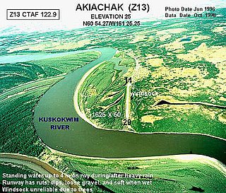
Akiachak(ACK-ee-uh-chuck) is a census-designated place (CDP) in the Bethel Census Area in the U.S. state of Alaska. The population was 627 at the 2010 census, up from 585 in 2000.

Funkley is a city in Beltrami County, Minnesota, United States. The population was five at the 2010 census, making the city the least populous incorporated place in Minnesota. It shared that distinction with Tenney until the latter dissolved in 2011.

Rossie is a town in St. Lawrence County, New York, United States. The population was 877 at the 2010 census. The town is named after the sister of an early land owner.

Bermuda Run is a town in Davie County, North Carolina, United States. The population was 1,725 at the 2010 census. It was incorporated in 1999 as a fully gated residential community near country clubs and golf courses like the Bermuda Run Country Club, Oak Valley Golf Club, and Tanglewood Park. In 2000, the town annexed into neighboring Hillsdale, picking up a commercial district. The town rests on the western bank of the Yadkin River along U.S. Route 158 and North Carolina Highway 801. Interstate 40 provides express access to Winston-Salem, the town's nearest urban center. In 2012 Kinderton Village was voluntarily annexed by the town of Bermuda Run.

Michie is a town in McNairy County, Tennessee. The population was 647 at the 2000 census and 591 at the 2010 census.
Banaskantha district is one of the thirty-three districts of the Gujarat state of India. The administrative headquarters of the district is at Palanpur which is also its largest city. The district is located in the Northeast of Gujarat and is presumably named after the West Banas River which runs through the valley between Mount Abu and Aravalli Range, flowing to the plains of Gujarat in this region and towards the Rann of Kutch. The district is famous for the Ambaji temple which draw many tourists. As of 2011, 13.27% of Banaskantha's population is urban and 86.70% is rural. It covers an area of 12703 km2 and is the second largest district in the state.

Amdanga is a community development block that forms an administrative division in North 24 Parganas district in the Indian state of West Bengal.
Hasnabad is a community development block that forms an administrative division in Basirhat subdivision of North 24 Parganas district in the Indian state of West Bengal.
Deganga is a community development block that forms an administrative division in North 24 Parganas district in the Indian state of West Bengal.
Gaighata is a community development block that forms an administrative division in Bangaon subdivision of North 24 Parganas district in the Indian state of West Bengal.
Sandeshkhali I is a community development block that forms an administrative division in Basirhat subdivision of North 24 Parganas district in the Indian state of West Bengal.

Charles Hill is a village in Ghanzi District of Botswana. It is located close to the Namibian border. Charles Hill is the second-largest village in Ghanzi District, with a population of 3,591 in 2011 census.
Macusani District is one of ten districts of the Carabaya Province in Peru. Its seat is Macusani.

Krzyżanna is a village in the administrative district of Gmina Mogilno, within Mogilno County, Kuyavian-Pomeranian Voivodeship, in north-central Poland. It lies approximately 11 kilometres (7 mi) east of Mogilno, 52 km (32 mi) south of Bydgoszcz, and 55 km (34 mi) south-west of Toruń.

Xanağa is a municipality and village in the Ordubad District of Nakhchivan, Azerbaijan. It is located near the Ordubad-Vanand highway, 14 km in the north-west from the district center, on the left bank of the Araz River. Its population is busy with gardening, farming and animal husbandry. There are secondary school, club, library and a medical center in the village. It has a population of 665. It forms part of the municipality of Vənənd.
Rosławice is a village in the administrative district of Gmina Ośno Lubuskie, within Słubice County, Lubusz Voivodeship, in western Poland.
Draginac is a village in the municipality of Loznica, Serbia. According to the 2002 census, the village has a population of 324 people.
Sandeshkhali-II is a community development block that forms an administrative division in Basirhat subdivision of North 24 Parganas district in the Indian state of West Bengal.
Kahlu Chal is a village in Sajjadrud Rural District, Bandpey-ye Sharqi District, Babol County, Mazandaran Province, Iran. At the 2006 census, its existence was noted, but its population was not reported.
Quartette or Quartette Mill or Quartette Landing, was a mining settlement, location of the stamp mill of the Quartette Mining Company, owner of the largest mine in the Searchlight Mining District and a steamboat landing on the Colorado River, in what is now Clark County, Nevada. It lay at an elevation of 646 feet.
| Urban villages |  | |
|---|---|---|
| Rural villages | ||
Coordinates: 22°25′53″S20°39′18″E / 22.43139°S 20.65500°E
| | This Botswana location article is a stub. You can help Wikipedia by expanding it. |