
Namibia, officially the Republic of Namibia, is a country in Southern Africa. Its western border is the Atlantic Ocean. It shares land borders with Zambia and Angola to the north, Botswana to the east and South Africa to the south and east. Although it does not border Zimbabwe, less than 200 metres of the Botswanan right bank of the Zambezi River separates the two countries. Namibia gained independence from South Africa on 21 March 1990, following the Namibian War of Independence. Its capital and largest city is Windhoek. Namibia is a member state of the United Nations (UN), the Southern African Development Community (SADC), the African Union (AU) and the Commonwealth of Nations.

Hardap is one of the fourteen regions of Namibia, its capital is Mariental. Hardap contains the municipality of Mariental, the towns Rehoboth and Aranos, and the self-governed villages Gibeon, Gochas, Kalkrand, Stampriet and Maltahöhe. It is home to the Hardap Dam.

The ǁKaras Region is the southernmost, largest, and least densely populated of the 14 regions of Namibia; its capital is Keetmanshoop. The name assigned to the region reflects the prominence of the Karas mountain range in its southern part. The ǁKaras region contains the municipality of Keetmanshoop, the towns Karasburg, Lüderitz and Oranjemund, and the self-governed villages Aroab, Berseba, Bethanie, Koës and Tses.

Erongo is one of the 14 regions of Namibia. The capital is Swakopmund. It is named after Mount Erongo, a well-known landmark in Namibia and in this area. Erongo contains the municipalities of Walvis Bay, Swakopmund, Henties Bay and Omaruru, as well as the towns Arandis, Karibib and Usakos. All the main centres within this region are connected by paved roads.

Ohangwena is one of the fourteen regions of Namibia, its capital is Eenhana. Major settlements in the region are the towns Eenhana and Helao Nafidi and the self-governed village of Okongo. As of 2020, Ohangwena had 150,724 registered voters.
Narayanpur is a community development block that forms an administrative division in the Jamtara Sadar subdivision in the Jamtara district, Jharkhand state, India. It is located 24 km from Jamtara, the district headquarters.
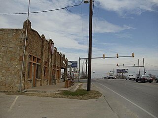
Cresson is a city located at the corners of Hood, Johnson, and Parker counties in the U.S. state of Texas. It is located at the intersection of U.S. Highway 377 and State Highway 171, 25 miles (40 km) southwest of Fort Worth. Incorporated in 2001, Cresson had a population of 741 at the 2010 census.

Ramnagar is a town in Barabanki district in the state of Uttar Pradesh, India. It is a town, tehsil and a nagar panchayat in Barabanki District in the Indian state of Uttar Pradesh.
Amdanga is a community development block that forms an administrative division in North 24 Parganas district in the Indian state of West Bengal.
Deganga is a community development block that forms an administrative division in North 24 Parganas district in the Indian state of West Bengal.
Sandeshkhali I is a community development block that forms an administrative division in Basirhat subdivision of North 24 Parganas district in the Indian state of West Bengal.
Kule is a village in Ghanzi District of Botswana. It is located close to the border with Namibia and has a primary school, clinic, customary court, social and development offices, animal health and production and police offices. The population was 741 in 2001 census.
Chanditala II is a community development block that forms an administrative division in Srirampore subdivision of Hooghly district in the Indian state of West Bengal.

Oshikuku is a town in Omusati Region in the north of Namibia. It is the district capital of Oshikuku Constituency.
Suti I is a community development block that forms an administrative division in the Jangipur subdivision of Murshidabad district in the Indian state of West Bengal.
Dedina Bara is a village in the municipality of Leskovac, Serbia. According to the 2002 census, the village has a population of 802 people.
Donji Branetići is a village in the municipality of Gornji Milanovac, Serbia. According to the 2002 census, the village has a population of 134 people.
Habra II is a community development block that forms an administrative division in Barasat Sadar subdivision of North 24 Parganas district in the Indian state of West Bengal.
Baduria is a community development block that forms an administrative division in Basirhat subdivision of North 24 Parganas district in the Indian state of West Bengal.
Sandeshkhali-II is a community development block that forms an administrative division in Basirhat subdivision of North 24 Parganas district in the Indian state of West Bengal.

