
Location of Makunda
Makunda is a village in Ghanzi District of Botswana. It is located close to the Namibian border. The population was 331 in 2001 census. [1]
Makunda is a village in Ghanzi District of Botswana. It is located close to the Namibian border. The population was 331 in 2001 census. [1]

Lawrence County is a county located in the U.S. state of Arkansas. As of the 2010 census, the population was 17,415. The county seat is Walnut Ridge. Lawrence County is Arkansas's second county, formed on January 15, 1815, and named for Captain James Lawrence who fought in the War of 1812. It is an alcohol prohibition or dry county.

Gibsonia is a former census-designated place (CDP) in Polk County, Florida, United States. The population was 4,507 at the 2000 census. Most of the community's core is now part of neighboring Lakeland. It is part of the Lakeland–Winter Haven Metropolitan Statistical Area.

Inverness is a suburban village in Cook County, Illinois, United States. The population was 7,399 at the 2010 census.

Arundel is a town in York County, Maine, United States. At the 2020 census, the population was 4,264. It is part of the Portland–South Portland–Biddeford, Maine Metropolitan Statistical Area. The Municipality of Arundel includes the constituent communities and neighbourhoods of: Arundel Village, Vinegar Hill, Riverside Arundel, Log Cabin Crossing, Goff Mill, Millers Crossing, and Cottagehill, among other neighbourhoods in an inland area adjacent to the Towns of Kennebunkport and Biddeford. In 2014, Arundel was named “Best Place to Live in Maine” by Downeast Magazine.

Twining is a village in Arenac County of the U.S. state of Michigan. The population was 181 at the 2010 census. The village is situated on the boundary between Mason Township on the west and Turner Township on the east, with about half of the village in each.

Wrenshall is a city in Carlton County, Minnesota, United States. The population was 399 at the 2010 census.

Ansley is a village in Custer County, Nebraska, United States. The population was 441 at the 2010 census.
Carlin is a small city located near the western border of Elko County in northeast Nevada, 23 miles (37 km) west of the city of Elko. It is part of the Elko Micropolitan Statistical Area. Carlin sits along Interstate 80 at an elevation of approximately 4,900 feet (1,500 m). As of the 2010 census, its population was 2,368, up from 2,161 at the 2000 census. The city was named for Civil War general William Passmore Carlin. Its slogan is "Where the Train Stops...And the Gold Rush Begins".

Stanton is a city in Mercer County, North Dakota, United States. It is the county seat of Mercer County. The population was 366 at the 2010 census. Stanton was founded in 1883 and became the county seat when Mercer County organized in 1884.

Nashville is a village in Holmes County, Ohio, United States. The population was 197 at the 2010 census.

LaRue is a village in Marion County, Ohio, United States. The population was 747 at the 2010 census. The village is served by Elgin Local School District. LaRue has a public library, a branch of Marion Public Library.

Lowville is a town in Columbia County, Wisconsin, United States. The population was 987 at the 2000 census. The unincorporated community of Lowville is located in the town.

Neva is a town in Langlade County, Wisconsin, United States. The population was 902 at the 2010 census, down from 994 at the 2000 census. The unincorporated communities of Deerbrook, Kempster, Neva, and Neva Corners are located in the town.
Santillana de Campos is a hamlet of Osorno la Mayor located in the province of Palencia, Castile and León, Spain. According to the 2005 census (INE), the village has a population of 114 inhabitants.
Kończewo is a village in the administrative district of Gmina Kobylnica, within Słupsk County, Pomeranian Voivodeship, in northern Poland. It lies approximately 7 kilometres (4 mi) south of Kobylnica, 11 km (7 mi) south-west of Słupsk, and 109 km (68 mi) west of the regional capital Gdańsk.
Lubuń is a village in the administrative district of Gmina Kobylnica, within Słupsk County, Pomeranian Voivodeship, in northern Poland. It lies approximately 8 kilometres (5 mi) south-east of Kobylnica, 10 km (6 mi) south of Słupsk, and 102 km (63 mi) west of the regional capital Gdańsk.
Aïn El Assel is a town and commune in El Taref Province, Algeria. According to the 1998 census it has a population of 12,482.
Gornja Batina is a village in Croatia.
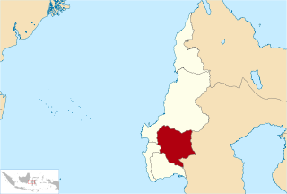
Mamasa Regency is one of the six regencies that make up the West Sulawesi Province, Indonesia, on the island of Sulawesi. It covers a land area of 3,005.88 km2. The population was 140,082 at the 2010 Census and 163,383 at the 2020 Census. Its capital is the town of Mamasa. The Mamasa people - which is a sub-group of the Toraja people - form the most common ethnic group. The only majority Protestant in the West Sumatera.
Lavelle is a census-designated place located in Butler Township, Schuylkill County in the state of Pennsylvania. Lavelle was part of the Lavelle-Locustdale CDP for the 2000 census, before splitting into the two separate CDPs of Lavelle and Locustdale. The community is located along Pennsylvania Route 901 As of the 2010 census the population was 742 residents.
| Urban villages |  | |
|---|---|---|
| Rural villages | ||
| General | |
|---|---|
| National libraries | |
Coordinates: 22°22′57″S20°6′47″E / 22.38250°S 20.11306°E
| | This Botswana location article is a stub. You can help Wikipedia by expanding it. |