
Bere Regis is a village and civil parish in Dorset, England, situated 6 miles (9.7 km) north-west of Wareham. In the 2011 census the civil parish had a population of 1,745.
Mukim Lumapas is a mukim in Brunei-Muara District, Brunei. It has an area of 62.10 square kilometres (23.98 sq mi); the population was 7,756 in 2016.

Bagratashen is a village in the Tavush Province of Armenia. The village is located near the border to Georgia, with the Georgian village of Sadakhlo being located on the other side of the border.
Tugaske is a village in the Canadian province of Saskatchewan within the Rural Municipality of Huron No. 223 and Census Division No. 7. It is nicknamed Gateway to Lake Diefenbaker. It is near Eyebrow Lake, a prairie lake in the Qu'Appelle Valley. It was named after an eyebrow-shaped hill also in the Qu'Appelle Valley above Eyebrow Lake. The lake, which is 9 km long and 1 km wide, is a bird sanctuary and is near Highway 627.

Ada West District is one of the twenty-nine districts in Greater Accra Region, Ghana. Originally it was formerly part of the then-larger Dangme East District in 1988, which was created from the former Dangme District Council, until the western part of the district was split off to create Ada West District on 28 June 2012; thus the remaining part has been renamed as Ada East District. The district assembly is located in the eastern part of Greater Accra Region and has Sege as its capital town.
Domapur is a village in Maharajganj block of Rae Bareli district, Uttar Pradesh, India. As of 2011, its population is 2,254, in 404 households. It has two primary schools and no healthcare facilities. It is located 10 km from Maharajganj, the block headquarters. The main staple foods are wheat and rice. It belongs to the nyaya panchayat of Chandapur.

Gajpati Khera is a village in Sareni block of Rae Bareli district, Uttar Pradesh, India. It is located 21 km from Lalganj, the tehsil headquarters. As of 2011, it has a population of 1,273 people, in 216 households. It has two primary schools and no healthcare facilities. It belongs to the nyaya panchayat of Bhojpur.
Deopur is a village in Sareni block of Rae Bareli district, Uttar Pradesh, India. It is located 21 km from Lalganj, the tehsil headquarters. As of 2011, it has a population of 1,737 people, in 302 households. It has one primary school and no healthcare facilities. It belongs to the nyaya panchayat of Rasulpur.
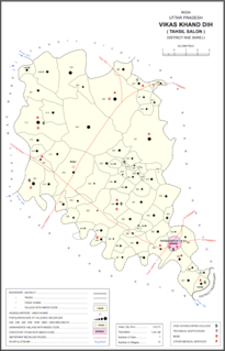
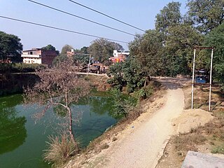
Kol is a village in Dih block of Rae Bareli district, Uttar Pradesh, India. It is located 23 km from Raebareli, the district headquarters. As of 2011, it has a population of 216 people, in 44 households. It has no schools and no healthcare facilities, and it does not host a permanent market or weekly haat. It belongs to the nyaya panchayat of Dih.

Sarai Kurmi is a village in Lalganj block of Rae Bareli district, Uttar Pradesh, India. It is located 4 km from Lalganj, the block and tehsil headquarters. As of 2011, it has a population of 843 people, in 197 households. It has no healthcare facilities and does not host a permanent market or a weekly haat. It belongs to the nyaya panchayat of Behta Kalan.
Pahuri is a village in Sareni block of Rae Bareli district, Uttar Pradesh, India. It is located 11 km from Lalganj, the tehsil headquarters. As of 2011, it has a population of 1,122 people, in 196 households. It hosts both a regular market and a weekly haat. It belongs to the nyaya panchayat of Bhoremau.
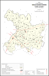
Mohanpur is a village in Khiron block of Rae Bareli district, Uttar Pradesh, India. It is located 22 km from Lalganj, the tehsil headquarters. As of 2011, it has a population of 425 people, in 78 households. It has no schools and no healthcare facilities and does not host a weekly haat or permanent market. It belongs to the nyaya panchayat of Paho.
Chak Gajraj is a village in Khiron block of Rae Bareli district, Uttar Pradesh, India. It is located 11 km from Lalganj, the tehsil headquarters. As of 2011, it has a population of 429 people, in 68 households. It has 1 primary school and no healthcare facilities and it does not host a weekly haat or a permanent market. It belongs to the nyaya panchayat of Semari.
Dhurai is a village in Khiron block of Rae Bareli district, Uttar Pradesh, India. It is located 19 km from Lalganj, the tehsil headquarters. As of 2011, it has a population of 4,481 people, in 867 households. It has 2 primary schools and no healthcare facilities and it hosts both a weekly haat and a permanent market. It belongs to the nyaya panchayat of Paho.
Jamkoriapur is a village in Khiron block of Rae Bareli district, Uttar Pradesh, India. It is located 21 km from Lalganj, the tehsil headquarters. As of 2011, it has a population of 881 people, in 191 households. It has 1 primary school and no healthcare facilities and it hosts a weekly haat but not a permanent market. It belongs to the nyaya panchayat of Tikwamau.
Akhaupur is a village in Khiron block of Rae Bareli district, Uttar Pradesh, India. It is located 18 km from Lalganj, the tehsil headquarters. As of 2011, it has a population of 1,338 people, in 258 households. It has 1 primary school and no healthcare facilities and it does not host a weekly haat or a permanent market. It belongs to the nyaya panchayat of Tikwamau.
Majhgawan, also spelled Majhigawan, is a village in Khiron block of Rae Bareli district, Uttar Pradesh, India. It is located 14 km from Lalganj, the tehsil headquarters. As of 2011, it has a population of 782 people, in 146 households. It has no schools and no healthcare facilities and does not host a weekly haat or a permanent market. It belongs to the nyaya panchayat of Deogaon.
Dahirapur is a village in Khiron block of Rae Bareli district, Uttar Pradesh, India. It is located 21 km from Lalganj, the tehsil headquarters. As of 2011, it has a population of 386 people, in 81 households. It has no schools and no healthcare facilities and does not host a weekly haat or a permanent market. It belongs to the nyaya panchayat of Tikwamau.
Khanpur Khusti is a village in Khiron block of Rae Bareli district, Uttar Pradesh, India. It is located 14 km from Lalganj, the tehsil headquarters. As of 2011, it has a population of 1,723 people, in 315 households. It has 1 primary school and no healthcare facilities and does not host a weekly haat or a permanent market. It belongs to the nyaya panchayat of Deogaon.

Bela Khara is a village in Rahi block of Rae Bareli district, Uttar Pradesh, India. It is located 15 km from Rae Bareli, the district headquarters. As of 2011, it has a total population of 5,928 people, in 1,071 households. It has one primary school and no medical facilities and it hosts both a weekly haat and a permanent market. It belongs to the nyaya panchayat of Bela Bhela.

