
Transportation in Botswana is provided by an extensive network of railways, highways, ferry services and air routes that criss-cross the country. The transport sector in Botswana played an important role in economic growth following its independence in 1966. The country discovered natural resources which allowed it to finance the development of infrastructure, and policy ensured that the transport sector grew at an affordable pace commensurate with demands for services.

Gaborone is the capital and largest city of Botswana with a population of 246,325 based on the 2022 census, about 10% of the total population of Botswana. Its agglomeration is home to 421,907 inhabitants at the 2011 census.
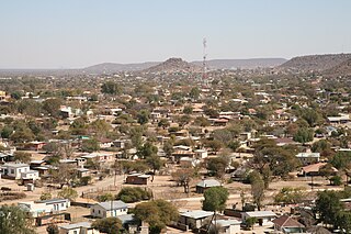
Ramotswa is a village in South-East District of Botswana, southwest of the capital of Gaborone. The population was 27,760 in 2011 census. It is the tribal capital of the BaLete, an ethnic majority springing from the Nguni tribe.

Palapye is a growing town in Botswana, situated about halfway between Francistown and Gaborone. Over the years its position has made it a convenient stopover on one of Southern Africa's principal north–south rail and road routes.
Mochudi is one of the larger villages in Botswana with a population of 44,815 people in 2011. It is situated in the Bakgatla tribal region, in Kgatleng District, about 37 km (23 mi) northeast of Gaborone. The village lies several kilometres from the main Gaborone–Francistown road, and can be accessed through a short turn at Pilane. Mochudi was settled by the Tswana people in 1871. The main attraction in Mochudi is the Phuthadikobo Museum which is perched at the top of a hill and holds a rich history of Bakgatla tribe and Batswana in general.

Kang is a village in Kgalagadi District of Botswana. It is situated in the Kalahari Desert and lies on the Trans-Kalahari Highway between Ghanzi in the north and Sekoma in the south. Kang also provides access to the Kgalagadi Transfrontier Park in the south-west and the Central Kalahari Game Reserve in the north-east. The route via Ghanzi takes one to the Namibian border, whilst that to Sekoma leads to Gaborone, the capital of Botswana. The population was 5,985 according to the 2011 census. Kang also falls under the Kgalagadi North constituency whose Member of Parliament is Hon. Talita Monnakgotla. The village is divided into seven wards which are; Gasekgalo, Gamonyemana, Gamotshoto, Gapanyana, Gamoriti, Kaatshwene and Tshwaragano ward. The village is led by a female chief, Kgosi Basadi Seipone who is the daughter to the late former chief Churchill Pego Seipone who died in 2010. The village's key development areas include the Central Roads Depot, Central Transport Organisation, Airstrip/Landing ground, mini Rural Administration Centre/ Service Centre, Botswana Open University Regional Campus, Brigade Centre, Police Station, Health Clinic, Magistrate Court, Department Road Transport Service offices, Wildlife offices, Botswana Power Corporation Offices, Water Utilities Corporation offices, Facility Management offices, Senior Secondary, Junior Secondary School and two primary schools.

Molepolole is a large village in Kweneng District, Botswana.

Francistown is the second-largest city in Botswana, with a population of about 103,417 and 147,122 inhabitants for its agglomeration at the 2022 census. It is located in eastern Botswana, about 400 kilometres (250 mi) north-northeast from the capital, Gaborone. Francistown is located at the confluence of the Tati and Ntshe rivers, and near the Shashe River and 90 kilometres (56 mi) from the international border with Zimbabwe.
Lobatse is a town in south-eastern Botswana, 70 kilometres south of the capital Gaborone, situated in a valley running north towards Gaborone and close to the border with South Africa. Lobatse has a population of 29,772 as of 2022. The town is an administrative district, with a town council.
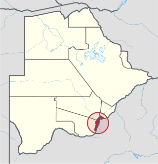
South-East is one of the districts of Botswana. The capital city of Botswana, Gaborone, is surrounded by this district. The administrative capital for the South-East district is the village of Ramotswa. In the southeast, South-East borders the North West Province of South Africa. Domestically, it borders Kgatleng in northeast, Kweneng in northwest, Southern in southwest.
Bobonong is a town in the Central District of Botswana 80 km from Selibe Phikwe town. Bobonong has a population of around 19,000. The Babirwa tribe can be found in this town. The Botswana Pink semi-precious stones can be found in Bobonong region. The Babirwa are known for harvesting the mophane worm. The locals refer to the town as Bobcity or formerly Lekgarapeng, which was derived from the stoney landscape of the town.

Botswana Railways (BR) is the national railway of Botswana.

The districts of Botswana are subdivided into sub-districts. The sub-districts are listed below, by district:

The wildlife of Botswana refers to the flora and fauna of this country. Botswana is around 90% covered in savanna, varying from shrub savanna in the southwest in the dry areas to tree savanna consisting of trees and grass in the wetter areas. Even under the hot conditions of the Kalahari Desert, many species survive; in fact the country has more than 2500 species of plants and 650 species of trees. Vegetation and its wild fruits are also extremely important to rural populations living in the desert and are the principal source of food, fuel and medicine for many inhabitants.
The history of Gaborone began with archaeological evidence in the area around Gaborone dating back to 400 BCE, and the first written accounts of Gaborone are from the earliest European settlers in the 19th century. Since the 1960s, when Botswana gained its independence from Britain and Gaborone became the capital, the city has grown from a small village in the Botswana scrubland to a major center in southern Africa.
Lejwana, Botswana is a small village in the Republic of Botswana in Africa. It is situated in the Southern District of Botswana. It lies between the coordinates 25°24'23S and 25°32'27E. It is situated between the villages of Gathwane, Pitsane, Kgoro, and Digawana. Lejwana is about 30 km from Lobatse and about 100 km by road from the capital Gaborone.
Molapowabojang is a village in the Southern District of Botswana, Located between Lobatse and Kanye, about 15 km North-West of Lobatse. With a population of about 7,520. This village falls under an administration of the Southern District Council which is headquartered in Kanye.

The Notwane River is a river in southeastern Botswana. Certain sections of its course form the international boundary with South Africa. Its mouth is at the head of the Limpopo River. It has a catchment area of 18,053 square kilometers.
Kgomokasitwa is a small village in the Southern District of Botswana, located some few kilometers north of Lobatse. To reach the village you travel by the A2 road between Lobatse and Kanye, then branch to the right at the Molapowabojang ward called Tshweneyagae. Kgomokasitwa has a population of about 1423. The village falls under the administration of the Southern District Council which is headquartered in Kanye, Botswana. For civil administration it falls under Moshupa Sub District.
Good Hope is a village in the Good Hope District of Botswana. It serves as the administrative center for the Good Hope District Council.
