Botswana, officially the Republic of Botswana, is a landlocked country in Southern Africa. Botswana is topographically flat, with approximately 70 percent of its territory part of the Kalahari Desert. It is bordered by South Africa to the south and southeast, Namibia to the west and north, Zambia to the north and Zimbabwe to the northeast. With a population of slightly over 2.4 million people and a comparable land area to France, Botswana is one of the most sparsely populated countries in the world. It is essentially the nation-state of the Tswana people, who constitute nearly 80 percent of the population.

Diamond is a solid form of the element carbon with its atoms arranged in a crystal structure called diamond cubic. Diamond as a form of carbon is tasteless, odourless, strong, brittle solid, colourless in pure form, a poor conductor of electricity, and insoluble in water. Another solid form of carbon known as graphite is the chemically stable form of carbon at room temperature and pressure, but diamond is metastable and converts to it at a negligible rate under those conditions. Diamond has the highest hardness and thermal conductivity of any natural material, properties that are used in major industrial applications such as cutting and polishing tools. They are also the reason that diamond anvil cells can subject materials to pressures found deep in the Earth.

Gaborone is the capital and largest city of Botswana with a population of 246,325 based on the 2022 census, about 10% of the total population of Botswana. Its agglomeration is home to 534,842 inhabitants at the 2022 census.

Cloncurry is a rural town and locality in the Shire of Cloncurry, Queensland, Australia. It is informally known by local people as The Curry. Cloncurry is the administrative centre of the Shire of Cloncurry.

The Jwaneng diamond mine is the richest diamond mine in the world, and also the second largest in the world. It is nicknamed "the Prince of Mines", and is located in south-central Botswana about 170 kilometers (110 mi) southwest of the city of Gaborone.

Port Douglas is a coastal town and locality in the Shire of Douglas, Queensland, Australia, approximately 60 km north of Cairns.
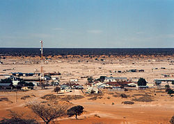
Mahalapye is a town located in the Central District of Botswana. The town has about 41,000 inhabitants and is situated along the main road between the capital Gaborone and the second largest city Francistown. Mahalapye has a bus station, a railway station, a couple of hotels and a market area with many shops and fast food restaurants, Water Shed mall is the latest attraction to those travelling from Gaborone to Francistown. It also has several petrol stations, some open 24 hours per day. Being situated on the edge of the Kalahari desert, the town and its local waterways are quite dry, except during the rainy season. In recent times, it has become a convenient stop-over town for travelers travelling to and from Gaborone.
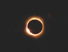
A total solar eclipse occurred at the Moon's descending node of orbit on Wednesday, December 4, 2002, with a magnitude of 1.0244. A solar eclipse occurs when the Moon passes between Earth and the Sun, thereby totally or partly obscuring the image of the Sun for a viewer on Earth. A total solar eclipse occurs when the Moon's apparent diameter is larger than the Sun's, blocking all direct sunlight, turning day into darkness. Totality occurs in a narrow path across Earth's surface, with the partial solar eclipse visible over a surrounding region thousands of kilometres wide. Occurring about 1.9 days after perigee, the Moon's apparent diameter was larger.

A total solar eclipse occurred at the Moon's ascending node of orbit on Thursday, June 21, 2001, with a magnitude of 1.0495. It was the first solar eclipse of the 21st century. A solar eclipse occurs when the Moon passes between Earth and the Sun, thereby totally or partly obscuring the image of the Sun for a viewer on Earth. A total solar eclipse occurs when the Moon's apparent diameter is larger than the Sun's, blocking all direct sunlight, turning day into darkness. Totality occurs in a narrow path across Earth's surface, with the partial solar eclipse visible over a surrounding region thousands of kilometres wide. Occurring about 2.25 days before perigee, the Moon's apparent diameter was larger.
Maralaleng is a village in Kgalagadi District of Botswana. It is located east of the district capital Tsabong and has a primary school. The climate in Maraleng is considered to be a desert climate. The population is 586 according to a 2011 census.
Maleshe is a village in Kgalagadi District of Botswana. It is located close the capital of the district, Tshabong, and it has a primary school. The population was 462 in 2011 census. Maleshe also has a clinic, small business tuckshops and retailers.
Maubelo is a village in Kgalagadi District of Botswana. It is located south of the district capital Tsabong and has a primary school. The population was 514 in the 2011 census.
Tshane is a village in Kgalagadi District of Botswana. It is situated in Kalahari Desert, and is served by local Tshane Airport. The village has a primary school and the population was 1020 in 2011 census. It has a !Xóõ cultural centre. The lowest temperature registered in Tshane was −8.0 °C (17.6 °F). The record high temperature registered in Tshane was 41.0 °C (105.8 °F).

A partial lunar eclipse will occur at the Moon’s ascending node of orbit on Saturday, June 15, 2030, with an umbral magnitude of 0.5025. A lunar eclipse occurs when the Moon moves into the Earth's shadow, causing the Moon to be darkened. A partial lunar eclipse occurs when one part of the Moon is in the Earth's umbra, while the other part is in the Earth's penumbra. Unlike a solar eclipse, which can only be viewed from a relatively small area of the world, a lunar eclipse may be viewed from anywhere on the night side of Earth. Occurring only about 23 hours before perigee, the Moon's apparent diameter will be larger.

A total solar eclipse will occur at the Moon's ascending node of orbit on Monday, November 25, 2030, with a magnitude of 1.0468. A solar eclipse occurs when the Moon passes between Earth and the Sun, thereby totally or partly obscuring the image of the Sun for a viewer on Earth. A total solar eclipse occurs when the Moon's apparent diameter is larger than the Sun's, blocking all direct sunlight, turning day into darkness. Totality occurs in a narrow path across Earth's surface, with the partial solar eclipse visible over a surrounding region thousands of kilometres wide. Occurring about 14 hours before perigee, the Moon's apparent diameter will be larger.

A total solar eclipse will occur at the Moon's ascending node of orbit on Saturday, December 5, 2048, with a magnitude of 1.044. A solar eclipse occurs when the Moon passes between Earth and the Sun, thereby totally or partly obscuring the image of the Sun for a viewer on Earth. A total solar eclipse occurs when the Moon's apparent diameter is greater than the Sun's, blocking all direct sunlight. Totality occurs in a narrow path across Earth's surface, with the partial solar eclipse visible over a surrounding region thousands of kilometres wide. Occurring about 16.5 hours before perigee, the Moon's apparent diameter will be larger.

An annular solar eclipse occurred at the Moon’s descending node of orbit on Saturday, October 14, 2023, with a magnitude of 0.952. A solar eclipse occurs when the Moon passes between Earth and the Sun, thereby totally or partly obscuring the image of the Sun for a viewer on Earth. An annular solar eclipse occurs when the Moon's apparent diameter is smaller than the Sun's, blocking most of the Sun's light and causing the Sun to look like an annulus (ring). An annular eclipse appears as a partial eclipse over a region of the Earth thousands of kilometres wide. Occurring about 4.6 days after apogee, the Moon's apparent diameter was smaller.

Primary energy consumption in Spain in 2020 was mainly composed of fossil sources. The largest sources are petroleum (42.3%), natural gas (19.8%) and coal (11.6%). The remaining 26.3% is accounted for by nuclear energy (12%) and different renewable energy sources (14.3%). Domestic production of primary energy includes nuclear (44.8%), solar, wind and geothermal (22.4%), biomass and waste (21.1%), hydropower (7.2%) and fossil (4.5%).

World energy supply and consumption refers to the global supply of energy resources and its consumption. The system of global energy supply consists of the energy development, refinement, and trade of energy. Energy supplies may exist in various forms such as raw resources or more processed and refined forms of energy. The raw energy resources include for example coal, unprocessed oil & gas, uranium. In comparison, the refined forms of energy include for example refined oil that becomes fuel and electricity. Energy resources may be used in various different ways, depending on the specific resource, and intended end use. Energy production and consumption play a significant role in the global economy. It is needed in industry and global transportation. The total energy supply chain, from production to final consumption, involves many activities that cause a loss of useful energy.