Vaalhoek

Last updated

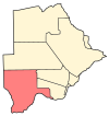
Vaalhoek is a village in Kgalagadi District of Botswana. It is located at the southern tip of Botswana, close to the border with South Africa, and it has a primary school. The population counted 355 in the 2011 census. [1]

Kgalagadi District District in Botswana

Kgalagadi is a district in southwest Botswana, lying along the country's border with Namibia and South Africa. The administrative center is Tsabong. The district of Kgalagadi covers a large part of the Kalahari Desert. It has a total area of 105,200 km² and has a population of 42,000 (2001). More than one-third of the district is covered by the Kgalagadi Transfrontier Park, which extends into South Africa, and which is a major tourist attraction.

Botswana republic in southern Africa

Botswana, officially the Republic of Botswana, is a landlocked country in Southern Africa. Formerly the British protectorate of Bechuanaland, Botswana adopted its new name after becoming independent within the Commonwealth on 30 September 1966. Since then, it has maintained a tradition of stable representative republic, with a consistent record of uninterrupted democratic elections and the best perceived corruption ranking in Africa since at least 1998. It is currently Africa's oldest continuous democracy.

South Africa Republic in the southernmost part of Africa

South Africa, officially the Republic of South Africa (RSA), is the southernmost country in Africa. It is bounded to the south by 2,798 kilometres (1,739 mi) of coastline of Southern Africa stretching along the South Atlantic and Indian Oceans; to the north by the neighbouring countries of Namibia, Botswana, and Zimbabwe; and to the east and northeast by Mozambique and Eswatini (Swaziland); and it surrounds the enclaved country of Lesotho. South Africa is the largest country in Southern Africa and the 25th-largest country in the world by land area and, with over 57 million people, is the world's 24th-most populous nation. It is the southernmost country on the mainland of the Old World or the Eastern Hemisphere. About 80 percent of South Africans are of Sub-Saharan African ancestry, divided among a variety of ethnic groups speaking different African languages, nine of which have official status. The remaining population consists of Africa's largest communities of European (White), Asian (Indian), and multiracial (Coloured) ancestry.

Related Research Articles

Demographics of Botswana

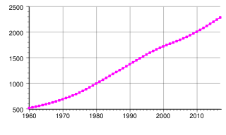
This article is about the demographic features of the population of Botswana, including population density, ethnicity, education level, health of the populace, economic status, religious affiliations and other aspects of the population.

Sarona, Wisconsin Town in Wisconsin, United States

Sarona is a town in Washburn County, Wisconsin, United States. The population was 382 at the 2000 census. The unincorporated community of Sarona is located in the town.

Oxford (CDP), Massachusetts CDP in Massachusetts, United States

Oxford is a census-designated place (CDP) in the town of Oxford in Worcester County, Massachusetts, United States. The population was 6,103 at the 2010 census.

Letlhakane Village in Central District, Botswana

Letlhakane is a village in the Central District of Botswana. It is located south of Mmatshumo and the population of the village was 22,911 in 2011 census.

Tsabong Place in Kgalagadi District, Botswana

Tsabong or Tshabong is the administrative centre of the Kgalagadi District, Botswana. It is located in the Kalahari Desert. The population was 8939 in 2011 census.

Ukwi village in Botswana

Ukwi is a village in the Kalahari desert of Kgalagadi District, western Botswana, 30 kilometers (19 mi) from the border with Namibia. The population was 459 in 2011 census. Although English is the official language of Botswana, numerous other languages are spoken in the area: Afrikaans, Tswana, Nama, and !Xóõ.

Hinduism in Botswana

Hinduism is a minority religion practised by 0.3 % of the population of Botswana.The practice of Hinduism in Botswana is concentrated in and around Gaborone and Selebi-Phikwe. The community of Hindus began to form in the early 20th century with the beginning of immigration from India to Botswana. Most Hindus in Botswana are of Indian descent.

Upper Brookfield, Queensland Suburb of Brisbane, Queensland, Australia

Upper Brookfield is an outer suburb of Brisbane, Australia. It is 16 kilometres (9.9 mi) west of the Brisbane CBD. Upper Brookfield is named after its neighbouring suburb Brookfield.

Barry Township, Pike County, Illinois Township in Illinois, United States

Barry Township is located in Pike County, Illinois. As of the 2010 census, its population was 1,675 and it contained 791 housing units.

Rapples Pan village in Botswana

Rapples Pan is a village in Kgalagadi District of Botswana. It is located at the south-western tip of Botswana, close to the South African border. It has a primary school, and the population was recorded as 283 by the 2011 census.

Gakhibane village in Botswana

Gakhibane (Gachibana) is a village in Kgalagadi District of Botswana. It is located close to the border with South Africa. Gachibana has a primary school, and the population was 746 in 2011 census.

Kolonkwane village in Botswana

Kolonkwane is a village in Kgalagadi District of Botswana. It is located close to the border with South Africa and it has a primary school. The population was 599 in 2011 census.

Bogogobo village in Botswana

Bogogobo is a village in Kgalagadi District of Botswana. It is located close to the border with South Africa and has a primary school. The population was 360 in 2011 census.

Bokspits village in Botswana

Bokspits is a village in Kgalagadi District of Botswana. It is the southernmost village in Botswana and is located close to the border with South Africa next to the Kgalagadi Transfrontier Park. Bokspits has a creche, primary school, clinic, police station, post office, government offices, churches, airstrip and various shops. There is a number of football teams for example the most famous one Bokspits United FC. Bokspits has experienced a great deal of growth and development e.g. tarred roads and communication networks. The population counted 507 in the 2011 census.

Struizendam village in Botswana

Struizendam is a village in Kgalagadi District of Botswana. It is located at the southern tip of Botswana, close to the border with South Africa, and it has a primary school. The population was 519 in 2011 census.

Maubelo village in Botswana

Maubelo is a village in Kgalagadi District of Botswana. It is located south of the district capital Tshabong and has a primary school. The population was 514 in 2011 census.

Tshane village in Botswana

Tshane is a village in Kgalagadi District of Botswana. It is situated in Kalahari Desert, and is served by local Tshane Airport. The village has a primary school and the population was 1020 in 2011 census. It has a !Xóõ cultural centre.

Bokaa Place in Kgatleng District, Botswana

Bokaa is a village in Kgatleng District of Botswana. The village is located around 20 km south-west of Mochudi and the population was 5,765 in 2011 census. The village is just north of the Bokaa Dam.

Mmankgodi Village in Kweneng District, Botswana

Mmankgodi is a village in Kweneng District of Botswana. It is located 35 km from Gaborone and around 30 km from the border with South Africa. The population of Mmankgodi was 4,997 in 2001 census.

Kurjače Village in Braničevo District, Serbia

Kurjače is a village in the municipality of Veliko Gradište, Serbia. According to the 2002 census, the village has a population of 964 people.

References

Coordinates: 26°52′8″S20°42′40″E / 26.86889°S 20.71111°E / -26.86889; 20.71111

Geographic coordinate system Coordinate system

A geographic coordinate system is a coordinate system that enables every location on Earth to be specified by a set of numbers, letters or symbols. The coordinates are often chosen such that one of the numbers represents a vertical position and two or three of the numbers represent a horizontal position; alternatively, a geographic position may be expressed in a combined three-dimensional Cartesian vector. A common choice of coordinates is latitude, longitude and elevation. To specify a location on a plane requires a map projection.