The Kalahari Desert is a large semi-arid sandy savanna in Southern Africa extending for 900,000 square kilometres (350,000 sq mi), covering much of Botswana, as well as parts of Namibia and South Africa.

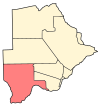
Kgalagadi is a district in southwest Botswana, lying along the country's border with Namibia and South Africa. The administrative center is Tsabong. The district of Kgalagadi covers a large part of the Kalahari Desert. It has a total area of 105,200 km2 and has a population of 42,000 (2001). More than one-third of the district is covered by the Kgalagadi Transfrontier Park, which extends into South Africa, and which is a major tourist attraction.

Kang is a village in Kgalagadi District of Botswana. It is situated in the Kalahari Desert and lies on the Trans-Kalahari Highway between Ghanzi in the north and Sekoma in the south. Kang also provides access to the Kgalagadi Transfrontier Park in the south-west and the Central Kalahari Game Reserve in the north-east. The route via Ghanzi takes one to the Namibian border, whilst that to Sekoma leads to Gaborone, the capital of Botswana. The population was 5,985 according to the 2011 census. Kang also falls under the Kgalagadi North constituency whose Member of Parliament is Hon. Talita Monnakgotla. The village is divided into seven wards which are; Gasekgalo, Gamonyemana, Gamotshoto, Gapanyana, Gamoriti, Kaatshwene and Tshwaragano ward. The village is led by a female chief, Kgosi Basadi Seipone who is the daughter to the late former chief Churchill Pego Seipone who died in 2010. The village's key development areas include the Central Roads Depot, Central Transport Organisation, Airstrip/Landing ground, mini Rural Administration Centre/ Service Centre, Botswana Open University Regional Campus, Brigade Centre, Police Station, Health Clinic, Magistrate Court, Department Road Transport Service offices, Wildlife offices, Botswana Power Corporation Offices, Water Utilities Corporation offices, Facility Management offices, Senior Secondary, Junior Secondary School and two primary schools.

Ghanzi is a district in western Botswana, bordering Namibia in the west and extending east into much of the interior of the country. The district's administrative centre is the town of Ghanzi. Most of the eastern half of Ghanzi makes up the Central Kalahari Game Reserve. The human population at the 2001 census was 43,370, less populous than that of any other district in Botswana. Ghanzi's area is 117,910 km².

Tsabong, also spelled Tshabong, is the administrative centre of the Kgalagadi District in Botswana. It is located in the Kalahari Desert. The population was 8939 in the 2011 census.
Ukhwi is a village in the Kalahari desert of Kgalagadi District, western Botswana, 30 kilometers (19 mi) from the border with Namibia. The population was 459 in 2011 census. Although English is the official language of Botswana, numerous other languages are spoken in the area: Afrikaans, Tswana, Nama, and !Xóõ.
Charles Hill is a village in Ghanzi District of Botswana. It is located close to the Namibian border. Charles Hill is the second-largest village in Ghanzi District, with a population of 3,591 in 2011 census.
Middlepits is a village in Kgalagadi District of Botswana. It borders South Africa and has an immigration border post.
Khawa is a village in Kgalagadi District of Botswana. It is located in the southern part of the district and has a primary school. It has a Christian church and a primitive clinic. The annual Khawa desert challenge is held here. The people speak Setswana as well as Afrikaans, English is understood. The vegetation in and around the village is highly overgrazed and it may seem like a desert inside the village although it is located in a grassland area. All the roads in and around the village are dirtroads. The population was 817 in 2011 census.
Tshane is a village in Kgalagadi District of Botswana. It is situated in Kalahari Desert, and is served by local Tshane Airport. The village has a primary school and the population was 1020 in 2011 census. It has a !Xóõ cultural centre. The lowest temperature registered in Tshane was −8.0 °C (17.6 °F). The record high temperature registered in Tshane was 41.0 °C (105.8 °F).
Lehututu is a village in Kgalagadi District of Botswana. It is in the Kalahari Desert, and it has primary and secondary schools. The population was 1,956 in 2011 census.
Lokgwabe is a village in Kgalagadi District of Botswana. It is located in the Kalahari Desert and the village has a primary school. The population was 1,417 in 2011 census.
Monong is a village in Kgalagadi District of Botswana. It is located in Kalahari Desert, and it has a primary school. The population was 267 in 2011 census.
Ngwatle is a village in Kgalagadi District of Botswana. It is located in the northern part of the district, in Kalahari Desert. The population was 228 in 2011 census.
Zutswa is a village in Kgalagadi District of Botswana. It is located in the Kalahari Desert and it has a primary school. The population was 469 in 2011 census.
Ngwatle is a village in the Kgalagadi District of Botswana. It is located in the Kalahari Desert, in the north-west part of the district. The population was 271 in 2011 census.
Make is a village in Kgalagadi District of Botswana. It is located in the Kalahari Desert and it has a primary school. The population was 398 in 2011 census.
Inalegolo is a village in Kgalagadi District of Botswana. It is located in the north-east part of the district, in Kalahari Desert, it has a primary school and a health post. The population was 533 in 2011 census. The chief of the village is Kgosi Keamogetse Ghubi.
Phuduhudu is a village in Kgalagadi District of Botswana. It is located in the northeast part of the district, in the Kalahari Desert, and it has a primary school. The population was 482 in the 2011 census.


