
Francistown is the second-largest city in Botswana, with a population of about 103,417 and 147,122 inhabitants for its agglomeration at the 2022 census. It is located in eastern Botswana, about 400 kilometres (250 mi) north-northeast from the capital, Gaborone. Francistown is located at the confluence of the Tati and Ntshe rivers, and near the Shashe River and 90 kilometres (56 mi) from the international border with Zimbabwe.

The North-East District is one of the administrative districts of Botswana. Its capital is Francistown. In 2011, North-East had a population of 60,264 people. The district is predominantly occupied by Kalanga-speaking people, the BaKalanga. The district is administered by a district administration and district council, which are responsible for local administration.
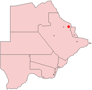
Masunga /ˈmɑːsuŋɡʌ/ is a Bakalanga settlement in the North-East District of Botswana. The village is the Headquarters of the North East District. The nearest city is Francistown which is about 120 km (75 mi) away. The Chief of the region is Kgosi Thabo Maruje Masunga III, who took over from his uncle Christopher Masunga.
Tutume is a large Bakalanga village located in the Tutume District of Botswana, about 50 km from the Zimbabwe border gate at Maitengwe. The nearest city is Francistown, about 100 km away. The village is a district headquarters and has a population of 23,000 .It is made up of wards: Sitabule(Madikwe),Tjilagwani(Selolwane), Thini and Madandume (Magapatona). In each ward there is a headman and his advisers in the kgotla. The main kgotla is located in Madikwe ward near Tutume Central Primary School. The village was named after the river "TUTUME", in Kalanga they will say "gwizi go Tutuma", meaning that the river was overflowing.
The Bamangwato is one of the eight "principal" Tswana chieftaincies of Botswana. The modern Bamangwato formed in the Central Serowe,Palapye & Mahalapye District, with its main town and capital at Serowe. The paramount chief, a hereditary position, occupies one of the fifteen places in Ntlo ya Dikgosi, the national House of Chiefs.
Shoshong is a town in Botswana, formerly the chief settlement of the eastern Bamangwato.
Plumtree is a town in Zimbabwe. Marula trees, wild plum trees grow abundantly in the area. The town was once called Getjenge by baKalanga. It is also often called Titji, meaning station, and referring to the railway station which was operating in the area around 1897.
Nswazwi is a small village in the Central District of Botswana. Located close to the border with Zimbabwe, it is named after the great chief John Nswazwi of Bakalanga people. The population was 1,741 at the 2001 census.
Mathangwane is a village in the Central District of Botswana administered under Tutume Sub-district Council. The village is located at the confluence of the Shashe and Vukwi rivers, 25 kilometres west of the City of Francistown along the A3 highway and almost entirely on the left bank of Shashe River. The population of the village was 5,075 in the 2011 national population and housing census. The village is characterised by many river valleys, mostly tributaries to Shashe River and used for identifying the village community wards (dikgotlana) boundaries.
Serule is a village in Central District of Botswana. Serule, with a latitude of -21.95 and a longitude of 27.3, is a streets, highways, roads, or railroad. The village is located along the road between Francistown and Palapye, and is an important railroad junction with rails leading towards north to Francistown, south to Palapye and east to the mining town of Selebi-Phikwe, 72 km from Palapye north up the A1 road, 88 km from Francistown down south the A1 road and 60 km west of Selibe Phikwe to the T-junction. The location is situated 340 kilometres east (90°) of the approximate centre of Botswana and 332 kilometres north east (26°) of the capital Gaborone.
Maunatlala is a settlement located in the Central District, categorized as tertiary settlement III by the National Settlement Policy. The village is located about 88 km East of Palapye and had a population of 4951 people as per the 2011 population census. Maunatlala is located within a tribal land under the administrative jurisdiction of the Ngwato Land Board through Maunatlala Subordinate Land Board. The village measures about 1302Ha in area. The village is the site of the Lotsane Dam. Maunatlala enjoys a strategic location with easy access and connectivity to South Africa, as it is located only about 30 KM from the boarder. According to Maunatlala village elders, the Babirwa baga Maunatlala originate from South Africa near Blaauberg Hills, they migrated from South Africa under the leadership of Kgosi Mophato-a-Phukula. The very first time they came to Botswana they settled at Serokolwane Hills near Serowe. Due to wars between Bangwato and Mashona tribe, Babirwa baga Maunatlala were forced to relocate to Lepokole. While in Lepokole, Kgosi Sekgoma of Bangwato, father to Khama the III sent a delegation from his tribe to caution Kgosi Phukula that there is a certain Ndebele tribe led by King Mzilikazi who were on their way to the North and they were attacking any tribe that they came across, seizing livestock in the process. Lepokole was situated on the Mzilikazi route, it was crucial for Kgosi Mophato and tribe to relocate to Shoshong and Join Bangwato. Baga Maunatlala stayed at Shoshong until the death of Kgosi Mophato, then relocated back to South Africa and settled at Ganana in 1876. Despite the fact that they had relocated to South Africa, they kept strong ties with Bangwato. In 1895 after the three Chiefs successfully securing protection against the Boers, Kgosi Khama sent a delegation to Kgosi Mapena who was leading the tribe at the time to inform him that a protectorate boundary has been set and he is outside the boundary. He was advised to cross into Botswana. Upon returning back to Botswana, they settled near a river called Kopung. The river was a source of drinking water for the tribe. They ended up naming the area Kopung.
The Ba-ka-Nswazwi people are originally Bapedi of Mujaji. The Bapedi of Mujaji are Kalangas originally from Munomutapa and were ruled by Mugudo. They are found in Tutume, Nswazwi, Marapong, Masunga and Nkange in Botswana.

The Kalanga or BaKalanga are a southern Bantu ethnic group mainly inhabiting Matebeleland in Zimbabwe, northern Botswana, and parts of the Limpopo Province in South Africa.
BaTalaote are an ethnic group found in the central district of Botswana and south-western parts of Zimbabwe. They are part of a large group of ethnic groups called Bakalanga. Over the years the Batalaote lost their language and those in Zimbabwe adopted Kalanga while the those in Botswana adopted Sengwato. The Talaunda and the Wadoma could share a common ancestor. Both tribes have significantly high cases of ectrodactyly.

The people of the country called Botswana are all referred to as Batswana(pl)/ Motswana(s) in reference to the country name or the land they all hail from, that is regardless of ethnicity, language, skin colour or heritage.
Batalaote are an ethnic group found in Botswana and south-western parts of Zimbabwe, commonly mistaken to be part of a larger group called Bakalanga-Banyai. They speak dialects such as:
Mmadinare is a village in the Central District of Botswana, 15 kilometers from Selibe Phikwe. The village is slowly growing into a town, with a population estimate of about 13 000 people of different tribes including Bangwato, Batalaote, Babirwa, and others. Mmadinare is located in the center of hills; like other villages in Southern Africa it was started during wars and hills were used as a form of protection from enemies, as they were able to see them from a distance.
Mandunyane is named after Kgosi Harry Mandunyane I, who ruled since 1973 when the village was established. The village is located in the Central District of Botswana in Tonota subdistrict. It is approximately 8 km (5.0 mi) north west of Tonota and roughly 30 km (19 mi) south west of Francistown.
Patayamatebele is a village in the North East District of Botswana near to the Dikgatlhong Dam.
The History of Botswana includes its pre-state history, its colonial period as the Bechuanaland Protectorate, and its modern history as a sovereign state.
