Kweneng District

Last updated
Kweneng
Botswana - Kweneng.svg
Location within Botswana
Coordinates: 24°00′S25°00′E / 24.000°S 25.000°E / -24.000; 25.000 Coordinates: 24°00′S25°00′E / 24.000°S 25.000°E / -24.000; 25.000
Country Flag of Botswana.svg Botswana
Capital Molepolole
Largest Mogoditshane
Sub-districts
Government
  Type District council
Area
  Total35,890 km2 (13,860 sq mi)
Population
 (2022 census)
  Total387,983
  Density11/km2 (28/sq mi)
Time zone UTC+2 (Central Africa Time)
HDI (2019)0.721 [1]
high · 4th
Website Official website

Kweneng is one of the districts of Botswana and is the recent historical homeland of the Bakwena people, the first group in Botswana converted to Christianity by famed missionary David Livingstone. Various landmarks, including Livingstone's Cave, allude to this history. The seat of the district's government is Molepolole, Botswana's most populous village (only trailing Botswana's two cities: Gaborone and Francistown).

Contents

It borders Central District in northeast, Kgatleng District on the east, South-East District in southeast, Southern District in south, Kgalagadi District in the west, Ghanzi District in the north. The district is administered by a district administration and district council which are responsible for local administration. Manyana rock paintings in Manyana village and Kgosi Sechele I Museum are the major attractions in the district.

As of 2011, the total population of the district was 304,549 compared to 230,335 in 2001. The growth rate of population during the decade was 2.83. As of 2006, the total number of people working in Kweneng East in agricultural sector was 7,212, 4,727 male and 2,484 female, with agriculture being the major profession.

Geography

Kweneng is the only district without a foreign border. It borders Central District in northeast, Kgatleng District on the east, South-East District in southeast, Southern District in south, Kgalagadi District in the west, Ghanzi District in the north. The region is traversed by the northwesterly line of equal latitude and longitude. Most part of Botswana has tableland slopes sliding from east to west. The region has an average elevation of around 915 m (3,002 ft) above the mean sea level. The vegetation type is Savannah, with tall grasses, bushes and trees. The annual precipitation is around 25 cm (9.8 in), most of which is received during the summer season from November to May. Most of the rivers in the region are seasonal, with Metsimotlhabe River, which are prone to flash floods, being the most prominent. [2] Manyana rock paintings in Manyana village and Kgosi Sechele I Museum are the major attractions in the district. [3]

Demographics

Historical population
YearPop.±%
1981117,127    
1991170,437+45.5%
2001230,335+35.1%
2011304,549+32.2%
2022387,983+27.4%
Sources: [4]

As of 2011, the total population of the district was 304,549 compared to 230,335 in 2001. The growth rate of population during the decade was 2.83. The population in the district was 15.04 per cent of the total population in the country. The sex ratio stood at 96.53 for every 100 males, compared to 93.90 in 2001. The average house hold size was 2.86 in 2011 compared to 4.34 in 2001. There were 11,142 craft and related workers, 4,692 clerks, 14,054 people working in elementary occupation 1,263 Legislators, Administrators & managers 6,378 Plant & machine operators and assemblers, 1,790 professionals, 7,227 service workers, shop & market sales workers, 2,988 skilled agricultural & related workers 4,125 technicians and associated professionals, making the total work force to 54,176. [4]

Education and economy

A school in the district Kgari sechele secondary school.jpg
A school in the district

As of 2011, there were a total of 101 schools in the district, with 16.70 per cent private schools. The total number of students in the Council schools was 43,930 while it was 3,646 in private schools. The total number of students enrolled in the district was 47,576 constituting 23,121 girls and 24,455 boys. The total number of qualified teachers was 1,849 with 1,449 females and 400 males. There were around 094 temporary teachers, 46 male and 140 female. There were a total of 6 untrained teachers in the district. [5]

As of 2006, the total number of people working in Kweneng East in the agricultural sector was 12,740, 7,786 male and 4,954 female. There were 3,314 people in construction industry, 4,141 in education, 178 in electricity and water, 557 in finance, 531 in foreign mission, 269 in health industry, 2,088 in hotels and restaurants, 200 in local government, 578 in manufacturing, 1,358 in mining & quarrying 2,503 in other community services, 858 in private households, 504 in public administration, 6,142 in real estate, 25,969 in transport and communication industry and 2,484 wholesale industries. The total working population was 7,212 with 706 males and 296 females. [6]

As of 2006, the total number of people working in Kweneng East in the agricultural sector was 7,212, 4,727 male and 2,484 female. There were 1,001 people in construction industry, 164 in education, 073 in electricity and water, 073 in finance, 250 in foreign mission, 228 in health industry, 064 in hotels and restaurants, 648 in local government, 11,963 in manufacturing, 5,309 in mining & quarrying 918 in other community services, 125 in private households, 45 in public administration, 458 in real estate, 756 in transport and communication industry and 435 wholesale industries. The total working population was 756 with 184 males and 219 females. [6]

Administration

Populated places
Population2001200620112022
Mogoditshane 14,24646,49357,63788,006
Molepolole 65,57067,59874,674
Thamaga 21,14119,54725,297
Gabane 10,39913,58114,84220,010
Kopong 5,5717,9999,52013,816
Metsimotlhabe 11,589
Letlhakeng 6,0327,2298,343

Botswana gained independence from the British in 1966 and adapted the colonial administration framework to form its district administration. The policies were modified during 1970-74 to address some of the basic issues. [7] The district is administered by a district administration and district council which are responsible for local administration. The policies for the administration are framed by the Ministry of Local Government. The major activities of the council are Tribal Administration, Remote Area Development and Local Governance. The executive powers of the council are vested on a commissioner appointed by the central government. Technical services wing of the Department of Local Government is responsible for developing roads, infrastructure in villages like water supply, schools and recreational facilities. [8] All the staff of the local administration expect District Administration are selected via Unified Local Government Services (ULGS) and the Ministry of Local Government is responsible for their training, deployment and career development. [9] Kweneng District has two census districts namely Kweneng East and Kweneng West. [10]

See also

Related Research Articles

<span class="mw-page-title-main">Kgalagadi District</span> District in Botswana

Kgalagadi is a district in southwest Botswana, lying along the country's border with Namibia and South Africa. The administrative center is Tsabong. The district of Kgalagadi covers a large part of the Kalahari Desert. It has a total area of 105,200 km² and has a population of 42,000 (2001). More than one-third of the district is covered by the Kgalagadi Transfrontier Park, which extends into South Africa, and which is a major tourist attraction.

<span class="mw-page-title-main">Kang, Botswana</span> Village in Kgalagadi District of Botswana

Kang is a village in Kgalagadi District of Botswana. It is situated in the Kalahari Desert and lies on the Trans-Kalahari Highway between Ghanzi in the north and Sekoma in the south. Kang also provides access to the Kgalagadi Transfrontier Park in the south-west and the Central Kalahari Game Reserve in the north-east. The route via Ghanzi takes one to the Namibian border, whilst that to Sekoma leads to Gaborone, the capital of Botswana. The population was 5,985 according to the 2011 census. Kang also falls under the Kgalagadi North constituency whose Member of Parliament is Hon. Talita Monnakgotla. The village is divided into seven wards which are; Gasekgalo, Gamonyemana, Gamotshoto, Gapanyana, Gamoriti, Kaatshwene and Tshwaragano ward. The village is led by a female chief, Kgosi Basadi Seipone who is the daughter to the late former chief Churchill Pego Seipone who died in 2010. The village's key development areas include the Central Roads Depot, Central Transport Organisation, Airstrip/Landing ground, mini Rural Administration Centre/ Service Centre, Botswana Open University Regional Campus, Brigade Centre, Police Station, Health Clinic, Magistrate Court, Department Road Transport Service offices, Wildlife offices, Botswana Power Corporation Offices, Water Utilities Corporation offices, Facility Management offices, Senior Secondary, Junior Secondary School and two primary schools.

<span class="mw-page-title-main">Molepolole</span> Village in Kweneng District, Botswana

Molepolole is a large village in Kweneng District, Botswana.

<span class="mw-page-title-main">Ghanzi District</span> District in Botswana

Ghanzi is a district in western Botswana, bordering Namibia in the west and extending east into much of the interior of the country. The district's administrative centre is the town of Ghanzi. Most of the eastern half of Ghanzi makes up the Central Kalahari Game Reserve. The human population at the 2001 census was 43,370, less populous than that of any other district in Botswana. Ghanzi's area is 117,910 km².

<span class="mw-page-title-main">Ghanzi</span> Town in Ghanzi District, Botswana

Ghanzi is a town in the middle of the Kalahari Desert the western part of the Republic of Botswana in southern Africa. The region is the country's pride in contributing a large portion towards the beef industry. In fact, Ghanzi farmers provide about 75% percent of beef exports, according to the Botswana Meat Commission, primarily to the United Kingdom and the European Union.

<span class="mw-page-title-main">Southern District (Botswana)</span> District in Botswana

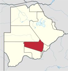
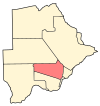
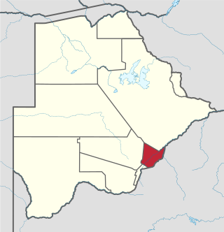
Southern is one of the districts of Botswana. The capital of Southern district is Kanye, home to the Bangwaketse and Barolong in Botswana. The Southern district is home to Botswana's second largest beef farmers where there are large privately owned ranges, and several government run beef ranges which provide agricultural support to the local farmers. Maize and sorghum, Botswana's staple crop, are also raised in the area. Southern district is where the third diamond mine of Botswana was found, which buoys Botswana's economic state of prosperity. It was the first district to house the capital city before being moved to Gaborone after independence.

<span class="mw-page-title-main">North-East District (Botswana)</span> District in Botswana

The North-East District is one of the administrative districts of Botswana. Its capital is Francistown. In 2011, North-East had a population of 60,264 people. The district is predominantly occupied by Kalanga-speaking people, the BaKalanga. The district is administered by a district administration and district council, which are responsible for local administration.

<span class="mw-page-title-main">North-West District (Botswana)</span> District in Botswana

The North-West District or Ngamiland is one of the first-level administrative subdivisions of Botswana. For census and administrative purposes Ngamiland is subdivided into Ngamiland East, Ngamiland West and Ngamiland Delta (Okavango). It is governed by a District Commissioner, appointed by the national government, and the elected North-West District Council. The administrative centre is Maun.

<span class="mw-page-title-main">Kgatleng District</span> District in Botswana

Kgatleng is one of the districts of Botswana, coterminous with the homeland of the Bakgatla people. Its capital is Mochudi, the hometown of protagonist Precious Ramotswe in Alexander McCall Smith's popular The No. 1 Ladies' Detective Agency series. According to the 2001 Census, Kgatleng had a population of 73,507 people.

<span class="mw-page-title-main">South-East District (Botswana)</span> District in Botswana

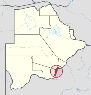
South-East is one of the districts of Botswana. The capital city of Botswana, Gaborone, is surrounded by this district. The administrative capital for the South-East district is the village of Ramotswa. In the southeast, South-East borders the North West Province of South Africa. Domestically, it borders Kgatleng in northeast, Kweneng in northwest, Southern in southwest.

<span class="mw-page-title-main">Central District (Botswana)</span> District in Botswana

Central is the largest of Botswana's districts in terms of area and population. It encompasses the traditional homeland of the Bamangwato people. Some of the most politically connected Batswana have come from the Central District, including former President Sir Seretse Khama, former President Festus Mogae, and former President Lt. General Seretse Ian Khama. The district borders the Botswanan districts of Chobe in the north, North-West in the northwest, Ghanzi in the west, Kweneng in southwest, Kgatleng in the south and North-East in the northeast, as well as Zimbabwe also in the northeast and South Africa in the southeast.

New Xade is a village located in the central part of the Ghanzi District of Botswana. The population was 1690 in 2021 census.

Mmankgodi is a village in Kweneng District of Botswana. It is located 35 km from Gaborone and around 30 km from the border with South Africa. The population of Mmankgodi was 6,802 in 2011 census.

<span class="mw-page-title-main">Chobe District</span> District in Botswana

Chobe District is an administrative district in the northern part of Botswana, with the headquarters in Kasane. In 2001 it was merged with Ngamiland, and until 2006 it shared with Ngamiland the North-West District Council as local government. Chobe National Park is in the Chobe District. As of 2011, the total population of the district was 23,347 compared to 18,258 in 2001. The growth rate of population during the decade was 2.49. The total number of workers constituted 12,059 with 6,113 males and 5,947 females, with majority of them working in public administration.

<span class="mw-page-title-main">Subdivisions of Botswana</span>

Botswana is divided into 10 districts

  1. Central District
  2. Ghanzi District
  3. Kgalagadi District
  4. Kgatleng District
  5. Kweneng District
  6. North-East District
  7. North-West District
  8. South-East District
  9. Southern District
  10. Chobe District
<span class="mw-page-title-main">Kgosi Sechele I Museum</span>

The Kgosi Sechele I Museum is a national museum located in Molepolole, Botswana. The museum was founded in 1902 and was made open to the public in 1992. Highlights include much memorabilia relating to the famous explorer David Livingstone.

<span class="mw-page-title-main">Manyana Rock Paintings</span> Historic site in Kweneng District, Botswana

The Manyana Rock Paintings are a collection of rock art and caves located at the Kolobeng hills, neighbouring Manyana, Southern District, Botswana. It is believed that the artworks were made by the Khoikhoi or the San people between 1100 AD and 1700 AD. The paintings are found on five cliff areas around the rocky hill. Today, the site is fenced and protected as a National Monument.

The Dithubaruba Cultural Festival is one of the national events celebrated in Botswana and is also marked in the Botswana Calendar of Events. It aims to promote Kweneng cultural heritage and create leisure time for the community.

References

  1. "Sub-national HDI - Area Database - Global Data Lab". hdi.globaldatalab.org. Retrieved 2018-09-13.
  2. Singh (2011). Geography. Tata McGraw-Hill Education. p. 12.53. ISBN   978-0-07-107480-3.
  3. "Tourist attractions in Botswana". Government of Botswana. Retrieved 12 November 2016.
  4. 1 2 "Census of Botswana, 2011". Central Statistics Office of Botswana. 2015. Retrieved 12 November 2016.
  5. "Education details of Botswana, 2011". Central Statistics Office of Botswana. 2015. Archived from the original on 12 November 2016. Retrieved 12 November 2016.
  6. 1 2 "Labour Force by industry in Botswana, 2008". Central Statistics Office of Botswana. 2008. Archived from the original on 13 November 2016. Retrieved 12 November 2016.
  7. Picard, Louis A. (1979). "Rural Development in Botswana: Administrative Structures and Public Policy". The Journal of Developing Areas. Louis A. Picard. 13 (3): 283–300. JSTOR   4190662.
  8. "Regional and Local government in Botswana". Common Wealth of Nations. Retrieved 12 November 2016.
  9. UN-HABITAT (2002). Local Democracy and Decentralization in East and Southern Africa: Experiences from Uganda, Kenya, Botswana, Tanzania, and Ethiopia. p. 57. ISBN   9789211316667.
  10. Gaotlhobogwe, Monkagedi. "Botswana broken into 19 new sub-districts". MMegi Online. Retrieved 11 November 2016.