Chobe District

Last updated
Chobe District
Zebras chobe national park.jpg
Game area in Chobe National Park
Botswana - Chobe.svg
Country Flag of Botswana.svg  Botswana
Capital Kasane
Area
  Total20,800 km2 (8,000 sq mi)
Population
 (2022 census)
  Total28,743
  Density1.4/km2 (3.6/sq mi)
Time zone UTC+2 (Central Africa Time)
HDI (2019)0.708 [1]
high · 7th

Chobe District is an administrative district in the northern part of Botswana, with the headquarters in Kasane. In 2001 it was merged with Ngamiland, and until 2006 it shared with Ngamiland the North-West District Council as local government. Chobe National Park is in the Chobe District. As of 2011, the total population of the district was 23,347 compared to 18,258 in 2001. The growth rate of population during the decade was 2.49. The total number of workers constituted 12,059 with 6,113 males and 5,947 females, with majority of them working in public administration.

Contents

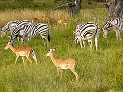
Kasane and Chobe National Park, the second largest national park in the country, are the major tourist attractions in the district. Chobe National Park also has the largest population of elephants in Africa. The district shares the international border of the country with Namibia and Zambia in the north, Zimbabwe in the east, and also the district borders along North-West district of the country.

The District is made up of nine villages, which are Kasane, Kachikau, Kazungula, Kavimba, Lesoma, Mabele/Muchinje, Parakarungu, Pandamatenga and Satau. [2] Kasane is the urban center of the District.

Geography

Game area in Chobe National Park Chobe National Park, elephants - panoramio - Frans-Banja Mulder.jpg
Game area in Chobe National Park

Kasane, Chobe National Park, Seboba Water Rapids, Pandamatenga Farms, Lesoma Memorial Monument, Kasane Hot Springs and Chobe River are the major tourist attractions in the district. [3] Most part of Botswana has tableland slopes sliding from east to west. The region has an average elevation of around 915 m (3,002 ft) above the mean sea level. The vegetation type is Savannah, with tall grasses, bushes and trees. The annual precipitation is around 65 cm (26 in), most of which is received during the summer season from November to May. Most of the rivers in the region are seasonal, with Chobe River, which are prone to flash floods, being the most prominent. [4] Chobe National Park is the second largest national park in the country and has the largest population of elephants in Africa. The district shares the international border of the country with Namibia and Zambia in the north, Zimbabwe in the east, and also the district borders along North-West district of the country. [5]

Culture

There are a number of ethnic groups which are found in the District. The Basubiya are found mainly at Parakarungu, Satau, Kavimba and Mabele. They are most dominant in Satau and Parakarungu. The Batawana are found in Kachikau and they are dry land farmers and pastoralists, they now practice molapo farming. In Pandamatenga the dominant tribe is Basarwa and they have moved from being hunters and gathers to ploughing. In Kasane there are a number of ethnic groups who came to the area looking for employment. [2]

Demographics

Historical population
YearPop.±%
19817,934    
199114,126+78.0%
200118,258+29.3%
201123,347+27.9%
202228,743+23.1%
Sources: [6]

As of 2011, the total population of the district was 23,347 compared to 18,258 in 2001. The growth rate of population during the decade was 2.49. The population in the district was 1.15 per cent of the total population in the country. The sex ratio stood at 106.17 for every 100 males, compared to 106.00 in 2001. The average house hold size was 2.45 in 2011 compared to 3.60 in 2001. There were 943 craft and related workers, 573 clerks, 2,053 people working in elementary occupation 186 legislators, administrators and managers, 1,083 plant and machine operators and assemblers, 128 professionals, 1,377 service workers, shop and market sales workers, 243 skilled agricultural and related workers, and 296 technicians and associated professionals, making the total work force 6,888. [6]

Education and economy

As of 2011, there were a total of 11 schools in the district, with 1.70 per cent private schools. The total number of students in the Council schools was 3,217 while it was 64 in private schools. The total number of students enrolled in the district was 3,281: 1,587 girls and 1,694 boys. The total number of qualified teachers was 154, 98 female and 56 male. There were around 16 temporary teachers, 6 male and 22 female. There was 1 untrained teacher in the district. [7]

As of 2006, 1,260 were involved in Agriculture, 322 in Construction, 236 in Education, 76 in Electricity & Water, 095 in Finance, 070 in Foreign Mission, 236 in Health, 510 in Hotels & Restaurants, 314 in Manufacturing, 107 in Private Households, 1,743 in Public Administration, 194 in Real Estate, 185 in Transport & Communications, and 681 in Wholesale & Retail Trade. The total number of workers constituted 12,059 with 6,113 males and 5,947 females. [8]

Administration

Botswana gained independence from the British in 1966 and adapted the colonial administration framework to form its district administration. The policies were modified during 1970–74 to address some of the basic issues. [9] The district is administered by a district administration and district council which are responsible for local administration. The policies for the administration are framed by the Ministry of Local Government. The major activities of the council are Tribal Administration, Remote Area Development and Local Governance. The executive powers of the council are vested on a commissioner appointed by the central government. Technical services wing of the Department of Local Government is responsible for developing roads, infrastructure in villages like water supply, schools and recreational facilities. [10] All the staff of the local administration except District Administration are selected via Unified Local Government Services (ULGS) and the Ministry of Local Government is responsible for their training, deployment and career development. [11] Chobe district was established during July 2008 and is not sub-divided. [12] [13]

Villages

Related Research Articles

<span class="mw-page-title-main">Transport in Botswana</span> Transport in Botswana

Transportation in Botswana is provided by an extensive network of railways, highways, ferry services and air routes that criss-cross the country. The transport sector in Botswana played an important role in economic growth following its independence in 1966. The country discovered natural resources which allowed it to finance the development of infrastructure, and policy ensured that the transport sector grew at an affordable pace commensurate with demands for services.

<span class="mw-page-title-main">Berea District</span> District in Lesotho

Berea is a district of Lesotho. In the west, Berea borders on the Free State Province of South Africa. Domestically, it borders on the following districts: Leribe District in the north, Thaba-Tseka District in southeast and Maseru District in the south. Teyateyaneng is the capital of the district. It is also home to the Kome Cave Dwellings. It is also the only district in Lesotho which is not named after its capital.

<span class="mw-page-title-main">Kgalagadi District</span> District in Botswana

Kgalagadi is a district in southwest Botswana, lying along the country's border with Namibia and South Africa. The administrative center is Tsabong. The district of Kgalagadi covers a large part of the Kalahari Desert. It has a total area of 105,200 km² and has a population of 42,000 (2001). More than one-third of the district is covered by the Kgalagadi Transfrontier Park, which extends into South Africa, and which is a major tourist attraction.

<span class="mw-page-title-main">Gorgol Region</span> Region of Mauritania

Gorgol is a region in southern Mauritania. Its capital is Kaédi and the Gorgol River forms parts of the landscape. Other major cities/towns include Mbout and Maghama. The region borders the Mauritanian regions of Brakna and Assaba to the north, the Mauritanian region of Guidimaka to the south-east and Senegal to the south-west. The Senegal River runs along the region's border with Senegal.

<span class="mw-page-title-main">Chobe National Park</span> National park in Botswana

Chobe National Park is Botswana's first national park, and also the most biologically diverse. Located in the north of the country, it is Botswana's third largest park, after Central Kalahari Game Reserve and Gemsbok National Park.

<span class="mw-page-title-main">Ghanzi District</span> District in Botswana

Ghanzi is a district in western Botswana, bordering Namibia in the west and extending east into much of the interior of the country. The district's administrative centre is the town of Ghanzi. Most of the eastern half of Ghanzi makes up the Central Kalahari Game Reserve. The human population at the 2001 census was 43,370, less populous than that of any other district in Botswana. Ghanzi's area is 117,910 km².

<span class="mw-page-title-main">Southern District (Botswana)</span> District in Botswana

Southern is one of the districts of Botswana. The capital of Southern district is Kanye, home to the Bangwaketse and Barolong in Botswana. The Southern district is home to Botswana's second largest beef farmers where there are large privately owned ranges, and several government run beef ranges which provide agricultural support to the local farmers. Maize and sorghum, Botswana's staple crop, are also raised in the area. Southern district is where the third diamond mine of Botswana was found, which buoys Botswana's economic state of prosperity. It was the first district to house the capital city before being moved to Gaborone after independence.

<span class="mw-page-title-main">North-East District (Botswana)</span> District in Botswana

The North-East District is one of the administrative districts of Botswana. Its capital is Francistown. In 2011, North-East had a population of 60,264 people. The district is predominantly occupied by Kalanga-speaking people, the BaKalanga. The district is administered by a district administration and district council, which are responsible for local administration.

<span class="mw-page-title-main">Kweneng District</span> District in Botswana

Kweneng is one of the districts of Botswana and is the recent historical homeland of the Bakwena people, the first group in Botswana converted to Christianity by famed missionary David Livingstone. Various landmarks, including Livingstone's Cave, allude to this history. The seat of the district's government is Molepolole, Botswana's most populous village.

<span class="mw-page-title-main">North-West District (Botswana)</span> District in Botswana

The North-West District or Ngamiland is one of the first-level administrative subdivisions of Botswana. For census and administrative purposes Ngamiland is subdivided into Ngamiland East, Ngamiland West and Ngamiland Delta (Okavango). It is governed by a District Commissioner, appointed by the national government, and the elected North-West District Council. The administrative centre is Maun.

<span class="mw-page-title-main">South-East District (Botswana)</span> District in Botswana

South-East is one of the districts of Botswana. The capital city of Botswana, Gaborone, is surrounded by this district. The administrative capital for the South-East district is the village of Ramotswa. In the southeast, South-East borders the North West Province of South Africa. Domestically, it borders Kgatleng in northeast, Kweneng in northwest, Southern in southwest.

<span class="mw-page-title-main">Central District (Botswana)</span> District in Botswana

Central is the largest of Botswana's districts in terms of area and population. It encompasses the traditional homeland of the Bamangwato people. Some of the most politically connected Batswana have come from the Central District, including former President Sir Seretse Khama, former President Festus Mogae, and former President Lt. General Seretse Ian Khama. The district borders the Botswanan districts of Chobe in the north, North-West in the northwest, Ghanzi in the west, Kweneng in southwest, Kgatleng in the south and North-East in the northeast, as well as Zimbabwe also in the northeast and South Africa in the southeast.

<span class="mw-page-title-main">Kazungula</span> Human settlement in Zambia

Kazungula is a small border town in Zambia, lying on the north bank of the Zambezi River about 70 kilometres (45 mi) west of Livingstone on the M10 Road.

<span class="mw-page-title-main">Kasane</span> Place in Chobe District, Botswana

Kasane is a town in Botswana, close to Africa's 'Four Corners', where four countries almost meet: Botswana, Namibia, Zambia and Zimbabwe. It is at the far north-eastern corner of Botswana where it serves as the administrative center of the Chobe District. The population of Kasane was 9,244 in 2011 census.

<span class="mw-page-title-main">Central Province, Zambia</span> Province of Zambia

Central Province is one of Zambia's ten provinces. The provincial capital is Kabwe, which is the home of the Mulungushi Rock of Authority. Central Province has an area of 94,394 km (58,654 mi). It borders eight other provinces and has eleven districts. The total area of forest in the province is 9,095,566 ha, and it has a national park and three game management areas. The first mine in the region was opened up in 1905 making the then Broken Hill town the first mining town. In 1966, he town's name was reverted to its indigenous name - Kabwe meaning 'ore' or 'smelting'.

<span class="mw-page-title-main">Southern Province, Zambia</span> Province of Zambia

Southern Province is one of Zambia's ten provinces, and home to Zambia's premier tourist attraction, Mosi-oa-Tunya, shared with Zimbabwe. The centre of the province, the Southern Plateau, has the largest area of commercial farmland of any Zambian province, and produces most of the maize crop.

<span class="mw-page-title-main">Sub-districts of Botswana</span>

The districts of Botswana are subdivided into sub-districts. The sub-districts are listed below, by district:

<span class="mw-page-title-main">Wildlife of Botswana</span> Flora and fauna of Botswana

The wildlife of Botswana refers to the flora and fauna of this country. Botswana is around 90% covered in savanna, varying from shrub savanna in the southwest in the dry areas to tree savanna consisting of trees and grass in the wetter areas. Even under the hot conditions of the Kalahari Desert, many species survive; in fact the country has more than 2500 species of plants and 650 species of trees. Vegetation and its wild fruits are also extremely important to rural populations living in the desert and are the principal source of food, fuel and medicine for many inhabitants.

Lesoma is a village in North-West District of Botswana. It is located in the eastern part of the district, which before 2001 formed Chobe District and is close to town of Kasane. Lesoma has both primary and secondary schools, and the population was 410 in 2001 census.

References

  1. "Sub-national HDI - Area Database - Global Data Lab". hdi.globaldatalab.org. Retrieved 2018-09-13.
  2. 1 2 Central Statistics Office (2009). Chobe District Population & Development Profile. Government Printers. pp. 1–2.
  3. "Tourist attractions in Botswana". Government of Botswana. Retrieved 12 November 2016.
  4. Singh (2011). Geography. Tata McGraw-Hill Education. p. 12.53. ISBN   978-0-07-107480-3.
  5. "Chobe District". Chobe District Council. Retrieved 12 November 2016.
  6. 1 2 "Census of Botswana, 2011". Central Statistics Office of Botswana. 2015. Retrieved 12 November 2016.
  7. "Education details of Botswana, 2011". Central Statistics Office of Botswana. 2015. Archived from the original on 12 November 2016. Retrieved 12 November 2016.
  8. "Labour Force by industry in Botswana, 2008". Central Statistics Office of Botswana. 2008. Archived from the original on 13 November 2016. Retrieved 12 November 2016.
  9. Picard, Louis A. (1979). "Rural Development in Botswana: Administrative Structures and Public Policy". The Journal of Developing Areas. Louis A. Picard. 13 (3): 283–300. JSTOR   4190662.
  10. "Regional and Local government in Botswana". Common Wealth of Nations. Retrieved 12 November 2016.
  11. UN-HABITAT (2002). Local Democracy and Decentralization in East and Southern Africa: Experiences from Uganda, Kenya, Botswana, Tanzania, and Ethiopia. p. 57. ISBN   9789211316667.
  12. Gaotlhobogwe, Monkagedi. "Botswana broken into 19 new sub-districts". MMegi Online. Retrieved 11 November 2016.
  13. Janssen, Rainer, ed. (2011). Bioenergy for sustainable development in Africa. Google books: Springer Science & Business media. p. 215. ISBN   9789400721814.

18°30′S25°00′E / 18.500°S 25.000°E / -18.500; 25.000