This article has multiple issues. Please help improve it or discuss these issues on the talk page . (Learn how and when to remove these template messages) (Learn how and when to remove this template message)
|

Mogobane
This article has multiple issues. Please help improve it or discuss these issues on the talk page . (Learn how and when to remove these template messages) (Learn how and when to remove this template message)
|
Mogobane

Newborn is a town in Newton County, Georgia, United States. The population was 696 at the 2010 census.

Rødby is a town, which was the seat of the former Rødby municipality on the island of Lolland in Denmark. The former Rødby municipality covered an area of 120 km², and had a total population of 6,590 (2005). Its last mayor was Hans Ole Sørensen, a member of the Venstre political party.

The Bosnian-Podrinje Canton Goražde is one of ten cantons of the Federation of Bosnia and Herzegovina, an entity in Bosnia and Herzegovina.

Şabran is a city in and the capital of the Şabran Rayon of Azerbaijan.

Ningguo is a county-level city in the southeast of Anhui province, People's Republic of China, under the administration of Xuancheng City and bordering Zhejiang province to the south and east. It has a population of 380,000 and an area of 2,447 km2 (945 sq mi).

Verin Sasnashen ; formerly known as Verin Karakoymaz and Verin Sasunashen, is a village in the Aragatsotn Province of Armenia.
Sinnickson is an unincorporated community in Accomack County, Virginia.
Qılıçlı is a village in the Lachin Rayon of Azerbaijan.
Yanıq Ələz is a village in the Siazan Rayon of Azerbaijan. The village forms part of the municipality of Yuxarı Ələz.
Həsənqoca is a village in the Khachmaz Rayon of Azerbaijan.
Bilbilyak is a village in the Khojavend Rayon of Azerbaijan.

Molwity is a village in the administrative district of Gmina Bartoszyce, within Bartoszyce County, Warmian-Masurian Voivodeship, in northern Poland, close to the border with the Kaliningrad Oblast of Russia.
Kalme is a village in Põltsamaa Parish, Jõgeva County in eastern Estonia.
Kuusiku-Nõmme is a village in Rapla Parish, Rapla County in northwestern Estonia.

Bitvrđa is a village in the municipality of Surdulica, Serbia. According to the 2002 census, the town has a population of 23 people.
Chà Tở is a commune (xã) and village of the Nậm Pồ District of Điện Biên Province, northwestern Vietnam.
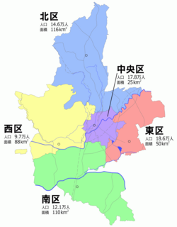
Kita-ku (北区) is one of the five wards of Kumamoto City, Japan. Meaning literally "north ward," it is bordered by the Nishi-ku, Chūō-ku, Higashi-ku and also by the cities of Yamaga, Kikuchi, Kōshi and the towns of Gyokutō and Kikuyō. As of 2012, it has a population of 140,684 people and an area of 115.65 km2.

Paspal Glacier is the 14.5 km long and 6.5 km wide glacier on Oscar II Coast, Graham Land in Antarctica situated southeast of Montgolfier Glacier and west of Hektoria Glacier. Draining from the southeast slopes of Forbidden Plateau and flowing southeastwards between Zagreus Ridge and Dugerjav Peak to join Green Glacier.

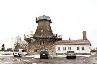
Pakruojis Manor is a former residential manor 2 kilometers from Pakruojis, Lithuania, on the right bank of the Kruoja river. Currently it is reconstructed and used as a hotel and restaurant.

Marsa Glacier is the 5 km long and 1.5 km wide glacier in Bangey Heights on the east side of the main ridge of north-central Sentinel Range in Ellsworth Mountains, Antarctica. It is situated northeast of Patleyna Glacier and northwest of the head of Padala Glacier. The glacier drains the north slopes of Golemani Peak, flows north-northwestwards between Oreshak Peak and Fucha Peak, and joins Embree Glacier west of Mount Schmid.
Coordinates: 24°59′10″S25°41′40″E / 24.98611°S 25.69444°E
| This Botswana location article is a stub. You can help Wikipedia by expanding it. |