
Transportation in Botswana is provided by internal and extensive network of railways, highways, ferry services and air routes that criss-cross the country.

The Cape to Cairo Road or Pan-African Highway, sometimes called the Great North Road in sub-Saharan Africa, was a proposed road that would stretch the length of Africa, from Cape Town to Cairo, through the Cape to Cairo Red Line of British colonies. The proposal was similar to the Cape to Cairo Railway, another proposed infrastructure project through the same colonies. Neither were completed before British colonial rule ended in the colonies.

Francistown is the second largest city in Botswana, with a population of about 100,079 and 150,800 inhabitants for its agglomeration at the 2011 census. and often described as the "Capital of the North". It is located in eastern Botswana, about 400 kilometres (250 mi) north-northeast from the capital, Gaborone. Francistown is located at the confluence of the Tati and Inchwe rivers, and near the Shashe River and 90 kilometres from the international border with Zimbabwe. Francistown was the centre of southern Africa's first gold rush and is still surrounded by old and abandoned mines. The City of Francistown is an administrative district, separated from North-East District. It is administered by Francistown City Council.

The North-East District is one of the administrative districts of Botswana. Its capital is Francistown. In 2011, North-East had a population of 60,264 people. The district is predominantly occupied by Kalanga-speaking people, the BaKalanga. The district is administered by a district administration and district council, which are responsible for local administration.
Bobonong is a town in the Central District of Botswana 80 km from Selibe Phikwe town. Bobonong has a population of around 19,000. The Babirwa tribe can be found in this town. The Botswana Pink semi-precious stones can be found in Bobonong region. The Babirwa are known for harvesting the mophane worm. The locals refer to the town as Bobcity or formerly Lekgarapeng, which was derived from the stoney landscape of the town.

Kasane is a town in Botswana, close to Africa's 'Four Corners', where four countries almost meet: Botswana, Namibia, Zambia and Zimbabwe. It is at the far north-eastern corner of Botswana where it serves as the administrative center of the Chobe District. The population of Kasane was 9,008 in 2011 census.

Plumtree is a town in Zimbabwe. Alongside marula trees, wild plum trees grew abundantly in the area, hence the name Plumtree. The town was once called Getjenge by the Kalanga people which is the dominant tribe. Another name which is mainly used is Titji which simple means station due to the railway station which was operating in the area around 1897.

Botswana Railways (BR) is the national railway of Botswana.

The Kazungula Ferry is a pontoon ferry across the 400-metre-wide (1,300 ft) Zambezi River between Botswana and Zambia. It is one of the largest ferries in south-central Africa, having a capacity of 70 tonnes. The service is provided by two motorised pontoons and operates between border posts at Kazungula, Zambia and Kazungula, Botswana.
Brunapeg is a settlement in the Matabeleland South Province of Zimbabwe. It is one of the urban centres in Mangwe District, one of the seven administrative districts in the province.

The Shashe River is a major left-bank tributary of the Limpopo River in Zimbabwe. It rises northwest of Francistown, Botswana and flows into the Limpopo River where Botswana, Zimbabwe and South Africa meet. The confluence is at the site of the Greater Mapungubwe Transfrontier Conservation Area.
Tshokwe is a village in Central District of Botswana. The village is located south-east of Francistown, near the border with Zimbabwe, and it has a primary school. The population was 897 according to the 2001 census.
List of Railway stations in Botswana include:

The Tati River is a river in northeast Botswana, a tributary of the Shashe River, which in turn is a tributary of the Limpopo River. The river flows through Francistown, where it is joined by the Ntshe River from the left.
The Dikgatlhong Dam is a dam near the village of Robelela on the Shashe River in Botswana, completed in December 2011. When full it will hold 400,000,000 cubic metres (1.4×10¹⁰ cu ft). The next largest dam in Botswana, the Gaborone Dam, has capacity of 141,000,000 cubic metres (5.0×10⁹ cu ft).
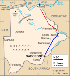
The North-South Carrier (NSC) is a pipeline in Botswana that carries raw water south for a distance of 360 kilometres (220 mi) to the capital city of Gaborone. Phase 1 was completed in 2000. Phase 2 of the NSC, under construction, will duplicate the pipeline to carry water from the Dikgatlhong Dam, which was completed in 2012. A proposed extension to deliver water from the Zambezi would add another 500 to 520 kilometres to the total pipeline length. The NSC is the largest engineering project ever undertaken in Botswana.
Matsiloje is a village in the North East District of Botswana on the west bank of the Ramokgwebana River, which forms the border with Zimbabwe.
The Ramokgwebana River is a river that defines part of the boundary between Botswana and Zimbabwe before entering the Shashe River from the left.
A7 Road is a national road in Zimbabwe. It is popularly known as the Bulawayo-Plumtree Road.
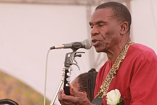
Ndingo Johwa is a Motswana trumpeter, flugelhornist, cornetist, Guitarist, composer and singer. He is known for his jazz compositions, as well as for writing the Phondanyama song. He is part of the Re Batswana Music Ensemble.
