History
The Tati District, a grant made to Captain Levert by the Matabele rulers, was the site of the first area of gold exploration in what is now Botswana. Very roughly corresponding to the North-East District of Botswana, it was bounded by the Ramoqueban to the east and the Shashi to the west. The Tati River, flowing between these two, enters the Shashe River about 6 kilometres (4 miles) above the point where the Ramoqueban enters the Shashe.
There is a border crossing between the village of Matsiloje in Botswana and the post of Warmley in Zimbabwe. In the 2000s, security was increased at the crossing due to the growing number of illegal immigrants entering Botswana from Zimbabwe, with a resultant increase in crime. Further north there is another crossing between Plumtree in Zimbabwe and Ramokgwebana in Botswana. During a period of low rainfall in 2010, the river largely dried up. There was tension between the people of the two towns who were competing for water from pools dug into the riverbed.

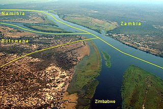
Botswana is a landlocked country located in Southern Africa, north of South Africa. Botswana occupies an area of 581,730 square kilometres (224,610 sq mi), of which 566,730 km2 (218,820 sq mi) are land. Botswana has land boundaries of combined length 4,347.15 kilometres (2,701.19 mi), of which the constituent boundaries are shared with Namibia, for 1,544 km (959 mi); South Africa 1,969 km (1,223 mi); Zimbabwe, 834 km (518 mi) and Zambia, 0.15 km (0.093 mi). Much of the population of Botswana is concentrated in the eastern part of the country.

Transportation in Botswana is provided by an extensive network of railways, highways, ferry services and air routes that criss-cross the country. The transport sector in Botswana played an important role in economic growth following its independence in 1966. The country discovered natural resources which allowed it to finance the development of infrastructure, and policy ensured that the transport sector grew at an affordable pace commensurate with demands for services.

The Bechuanaland Protectorate was a protectorate established on 31 March 1885 in Southern Africa by the United Kingdom. It became the Republic of Botswana on 30 September 1966.

Francistown is the second-largest city in Botswana, with a population of about 103,417 and 147,122 inhabitants for its agglomeration at the 2022 census. It is located in eastern Botswana, about 400 kilometres (250 mi) north-northeast from the capital, Gaborone. Francistown is located at the confluence of the Tati and Ntshe rivers, and near the Shashe River and 90 kilometres (56 mi) from the international border with Zimbabwe.

The North-East District is one of the administrative districts of Botswana. Its capital is Francistown. In 2011, North-East had a population of 60,264 people. The district is predominantly occupied by Kalanga-speaking people, the BaKalanga. The district is administered by a district administration and district council, which are responsible for local administration.
Kazungula is a small border town in Zambia, lying on the north bank of the Zambezi River about 70 kilometres (45 mi) west of Livingstone on the M10 Road.
Plumtree is a town in Zimbabwe. Marula trees, wild plum trees grow abundantly in the area. The town was once called Getjenge by baKalanga. Another name by which it is often caled, is Titji, meaning station and referring to the railway station which was operating in the area around 1897.
Ramokgwebana is a village in the North-East District of Botswana, close to the eastern border, which is defined by the Ramokgwebana River. Plumtree, Zimbabwe is on the other side of the border crossing.

Thuli Parks and Wildlife Land is a protected area in south-western Zimbabwe. It comprises four areas within the Zimbabwe Parks and Wildlife Estate and covers the entire west bank of the Shashe River within the Thuli Circle.

The Shashe River is a major left-bank tributary of the Limpopo River in Zimbabwe. It rises northwest of Francistown, Botswana and flows into the Limpopo River where Botswana, Zimbabwe and South Africa meet. The confluence is at the site of the Greater Mapungubwe Transfrontier Conservation Area.
Mathangwane is a village in the Central District of Botswana administered under Tutume Sub-district Council. The village is located at the confluence of the Shashe and Vukwi rivers, 25 kilometres west of the City of Francistown along the A3 highway and almost entirely on the left bank of Shashe River. The population of the village was 5,075 in the 2011 national population and housing census. The village is characterised by many river valleys, mostly tributaries to Shashe River and used for identifying the village community wards (dikgotlana) boundaries.

The Kalanga or BaKalanga are a southern Bantu ethnic group mainly inhabiting Matebeleland in Zimbabwe, northern Botswana, and parts of the Limpopo Province in South Africa.
The Tati River is a river in northeast Botswana, a tributary of the Shashe River, which in turn is a tributary of the Limpopo River. The river flows through Francistown, where it is joined by the Ntshe River from the left.

Water Utilities Corporation (WUC) is a government-owned corporation that provides water and waste water management services in Botswana. The Board is appointed by the Minister of Minerals, Energy and Water Resources. The water supply is critically important in the arid or semi-arid environment of Botswana.
The Dikgatlhong Dam is a dam near the village of Robelela on the Shashe River in Botswana, completed in December 2011. When full it will hold 400,000,000 cubic metres (1.4×10¹⁰ cu ft). The next largest dam in Botswana, the Gaborone Dam, has capacity of 141,000,000 cubic metres (5.0×10⁹ cu ft).

The Zambezi River Authority (ZRA) is a corporation jointly and equally owned by the governments of Zambia and Zimbabwe.
Patayamatebele is a village in the North East District of Botswana near to the Dikgatlhong Dam.
Matsiloje is a village in the North East District of Botswana on the west bank of the Ramokgwebana River, which forms the border with Zimbabwe.

The border between Botswana and South Africa is 1,969 kilometres (1,223 mi) long. More than 90% of the border follows rivers, including the Nossob, Molopo, Marico and Limpopo.
Zwenshambe is a village in the North-East District of Botswana. It is situated between Gungwe village in the west, Nlapkhwane village in the east, Mulambakwena village in the south and the Zimbabwe border in the north. It is not far from the Ramokgwebana Border Post. The nearest city to Zwenshambe is Francistown which is also the second largest city in Botswana.
