
Gaborone is the capital and largest city of Botswana with a population of 246,325 based on the 2022 census, about 10% of the total population of Botswana. Its agglomeration is home to 534,842 inhabitants at the 2022 census.

The Northern Cape is the largest and most sparsely populated province of South Africa. It was created in 1994 when the Cape Province was split up. Its capital is Kimberley. It includes the Kalahari Gemsbok National Park, part of the Kgalagadi Transfrontier Park and an international park shared with Botswana. It also includes the Augrabies Falls and the diamond mining regions in Kimberley and Alexander Bay.

North West is a province of South Africa. Its capital is Mahikeng. The province is located to the west of the major population centre and province of Gauteng and south of Botswana.

Southern Africa is the southernmost region of Africa. No definition is agreed upon, but some groupings include the United Nations geoscheme, the intergovernmental Southern African Development Community, and the physical geography definition based on the physical characteristics of the land.

Palapye is a growing town in Botswana, situated about halfway between Francistown and Gaborone. Over the years its position has made it a convenient stopover on one of Southern Africa's principal north–south rail and road routes.

Francistown is the second-largest city in Botswana, with a population of about 103,417 and 147,122 inhabitants for its agglomeration at the 2022 census. It is located in eastern Botswana, about 400 kilometres (250 mi) north-northeast from the capital, Gaborone. Francistown is located at the confluence of the Tati and Ntshe rivers, and near the Shashe River and 90 kilometres (56 mi) from the international border with Zimbabwe.
Lobatse is a town in south-eastern Botswana, 70 kilometres south of the capital Gaborone, situated in a valley running north towards Gaborone and close to the border with South Africa. Lobatse has a population of 29,772 as of 2022. The town is an administrative district, with a town council.

Ghanzi is a district in western Botswana, bordering Namibia in the west and extending east into much of the interior of the country. The district's administrative centre is the town of Ghanzi. Most of the eastern half of Ghanzi makes up the Central Kalahari Game Reserve. The human population at the 2022 census was 56,555, less populous than that of any other district in Botswana. Ghanzi's area is 117,910 km².

Southern is one of the districts of Botswana. The capital of Southern district is Kanye, home to the Bangwaketse and Barolong in Botswana. The Southern district is home to Botswana's second largest beef farmers where there are large privately owned ranges, and several government run beef ranges which provide agricultural support to the local farmers. Maize and sorghum, Botswana's staple crop, are also raised in the area. Southern district is where the third diamond mine of Botswana was found, which buoys Botswana's economic state of prosperity. It was the first district to house the capital city before being moved to Gaborone after independence.

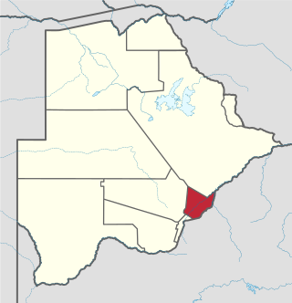
The North-East District is one of the administrative districts of Botswana. Its capital is Francistown. In 2011, North-East had a population of 60,264 people. The district is predominantly occupied by Kalanga-speaking people, the BaKalanga. The district is administered by a district administration and district council, which are responsible for local administration.

The North-West District or Ngamiland is one of the first-level administrative subdivisions of Botswana. For census and administrative purposes Ngamiland is subdivided into Ngamiland East, Ngamiland West and Ngamiland Delta (Okavango). It is governed by a District Commissioner, appointed by the national government, and the elected North-West District Council. The administrative centre is Maun.
Kgatleng is one of the districts of Botswana, coterminous with the homeland of the Bakgatla people. Its capital is Mochudi, the hometown of protagonist Precious Ramotswe in Alexander McCall Smith's popular The No. 1 Ladies' Detective Agency series. According to the 2001 Census, Kgatleng had a population of 73,507.

Central is the largest of Botswana's districts in terms of area and population. It encompasses the traditional homeland of the Bamangwato people. Some of the most politically connected Batswana have come from the Central District, including former President Sir Seretse Khama, former President Festus Mogae, and former President Lt. General Seretse Ian Khama. The district borders the Botswanan districts of Chobe in the north, North-West in the northwest, Ghanzi in the west, Kweneng in southwest, Kgatleng in the south and North-East in the northeast, as well as Zimbabwe also in the northeast and South Africa in the southeast.
Bobonong is a town in the Central District of Botswana 80 km from Selibe Phikwe town. Bobonong has a population of around 19,000. The Babirwa tribe can be found in this town. The Botswana Pink semi-precious stones can be found in Bobonong region. The Babirwa are known for harvesting the mophane worm. The locals refer to the town as Bobcity or formerly Lekgarapeng, which was derived from the stoney landscape of the town.

Kasane is a town in Botswana, close to Africa's 'Four Corners', where the borders of Botswana, Namibia, Zambia and Zimbabwe almost meet. The town is at the far northeastern corner of Botswana where it serves as the administrative center of the Chobe District. The population of Kasane was 9,244 at the 2011 census.
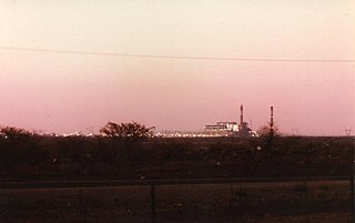
Morupule Thermal Power Station is a coal-fired power station in Botswana. It is responsible for an estimated 80 percent of the country's domestic power generation.

The people of the country called Botswana are all referred to as Batswana(pl)/ Motswana(s) in reference to the country name or the land they all hail from, that is regardless of ethnicity, language, skin colour or heritage.
Botswana Power Corporation (BPC) is a state-owned company for electrical power generation, transmission and distribution in Botswana. It was established in 1970 and is currently the only electricity supplier in the country. BPC represents Botswana in the Southern African Power Pool. Morupule Power Station (coal-fired) in Palapye supplies 80% of domestically generated electricity, however the country is dependent on importing energy from its neighbours. Its capacity is estimated to be around 132 MW. The region's main power supplier, South Africa, is experiencing its own problems with under-capacity blackouts. A plan to boost Morupule station with four new 150 MW units is underway and gathering financial support from several sources.
Matsiloje is a village in the North East District of Botswana on the west bank of the Ramokgwebana River, which forms the border with Zimbabwe.
Kgomokasitwa is a small village in the Southern District of Botswana, located some few kilometers north of Lobatse. To reach the village you travel by the A2 road between Lobatse and Kanye, then branch to the right at the Molapowabojang ward called Tshweneyagae. Kgomokasitwa has a population of about 1423. The village falls under the administration of the Southern District Council which is headquartered in Kanye, Botswana. For civil administration it falls under Moshupa Sub District.
