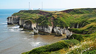
The East Riding of Yorkshire, often abbreviated to the East Riding or East Yorkshire, is a ceremonial county in the Yorkshire and the Humber region of England. It borders North Yorkshire to the north and west, South Yorkshire to the south-west, and Lincolnshire to the south across the Humber Estuary. The city of Kingston upon Hull is the largest settlement.
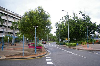
Palmerston is a planned satellite city of Darwin, the capital and largest city of Australia's Northern Territory. The city is situated approximately 20 kilometres from Darwin and 10 kilometres from Howard Springs and the surrounding rural areas. Palmerston had a population of 33,695 at the 2016 census, making it the second largest city in the Northern Territory. According to the 2021 census, the population grew to 37,247 people.
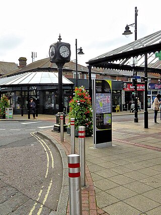
The Borough of Eastleigh is a local government district with borough status in Hampshire, England. It is named after its main town of Eastleigh, where the council is based. The borough also contains the town of Hedge End along with several villages, many of which form part of the South Hampshire urban area.

The City of Chelmsford is a local government district with borough and city status in Essex, England. It is named after its main settlement, Chelmsford, which is also the county town of Essex. As well as the settlement of Chelmsford itself, the district also includes the surrounding rural area and the town of South Woodham Ferrers.

Dodoma Region is one of Tanzania's 31 administrative regions. The regional capital is the city of Dodoma. Dodoma is located in central Tanzania, bordered by Singida region to the west, Manyara region to the north, Iringa region to the south, and Morogoro region to the east. Dodoma region hosts the nation's capital city, where the legislative assembly of Bunge is based. Dodoma region also hosts one of the largest universities in Tanzania: University of Dodoma. The region is the home of the Tanzanian wine industry, which is the second largest wine industry on the continent after South Africa. According to the 2022 national census, the region had a population of 3,085,625; in the 2012 national census, the population was 2,083,588.

Babati Rural District is a district of Manyara Region of Tanzania, East Africa. The administrative capital of the district is Babati town, 172 km (107 mi) south of Arusha. The district covers an area of 6,069 km2 (2,343 sq mi), a large proportion (640 km2) of which is covered by the water bodies of Lake Babati, Lake Burunge and Lake Manyara. The district is bordered to the north by Arusha Region, to the south east by Simanjiro District, to the south by Dodoma Region, to the south west by Hanang District, and to the north west by Mbulu District. Babati Urban District is located within the district.

The North-East District is one of the administrative districts of Botswana. Its capital is Francistown. In 2011, North-East had a population of 60,264 people. The district is predominantly occupied by Kalanga-speaking people, the BaKalanga. The district is administered by a district administration and district council, which are responsible for local administration.

Mwenezi, originally known as Nuanetsi, is a small district situated in southern Zimbabwe. It is bisected by the Mwenezi River and the A4 highway, the main thoroughfare that connects the town of Beitbridge, on the border with South Africa, to Masvingo.

The Shashe River is a major left-bank tributary of the Limpopo River in Zimbabwe. It rises northwest of Francistown, Botswana and flows into the Limpopo River where Botswana, Zimbabwe and South Africa meet. The confluence is at the site of the Greater Mapungubwe Transfrontier Conservation Area.
Tshokwe is a village in Central District of Botswana. The village is located south-east of Francistown, near the border with Zimbabwe, and it has a primary school. The population was 897 according to the 2001 census.
Robelela is a village in Central District of Botswana. It is located south-east of Francistown, close to the border with Zimbabwe. The population was 471 in 2001 census.

Kyankwanzi District is the westernmost district in the Central Region of Uganda and Buganda Kingdom, bordering Bunyoro. The district headquarters are in Butemba Town.
The Tati River is a river in northeast Botswana, a tributary of the Shashe River, which in turn is a tributary of the Limpopo River. The river flows through Francistown, where it is joined by the Ntshe River from the left.
The Dikgatlhong Dam is a dam near the village of Robelela on the Shashe River in Botswana, completed in December 2011. When full it will hold 400,000,000 cubic metres (1.4×10¹⁰ cu ft). The next largest dam in Botswana, the Gaborone Dam, has capacity of 141,000,000 cubic metres (5.0×10⁹ cu ft).

The North-South Carrier (NSC) is a pipeline in Botswana that carries raw water south for a distance of 360 kilometres (220 mi) to the capital city of Gaborone. Phase 1 was completed in 2000. Phase 2 of the NSC, under construction, will duplicate the pipeline to carry water from the Dikgatlhong Dam, which was completed in 2012. A proposed extension to deliver water from the Zambezi would add another 500 to 520 kilometres to the total pipeline length. The NSC is the largest engineering project ever undertaken in Botswana.
Mmamashia is a location in Botswana about 15 kilometres (9.3 mi) north of the capital city of Gaborone that is the site of the Mmamashia water treatment plant and master balancing reservoir.
Patayamatebele is a village in the North East District of Botswana near to the Dikgatlhong Dam.
Matsiloje is a village in the North East District of Botswana on the west bank of the Ramokgwebana River, which forms the border with Zimbabwe.

Columbina Rural Service Center is a populated place in Zhombe. It is 95 km northwest of Kwekwe and 67 km southwest of Kadoma.
